
Bairabi is a census town in Kolasib district in the state of Mizoram, India. It is also the railhead of Mizoram, 117 km from the Capital, Aizawl.

Mizoram University is a central university under the University Grants Commission, Government of India, and was established on 2 July 2001, by the Mizoram University Act (2000) of the Parliament of India. The President of India is the official Visitor, and the Governor of Mizoram acts as the Chief Rector as per Mizoram University (Amendment) Bill, 2007. According to the Act, the objectives of the university are "to disseminate and advance knowledge by providing instructional and research facilities in such branches of learning as it may deem fit, to make provisions for integrated courses in humanities, natural and physical sciences, social sciences, forestry and other allied disciplines in the educational programmes of the University; to take appropriate measures for promoting innovations in teaching-disciplinary studies and research; to educate and train man-power in the development of the state of Mizoram; and to pay special attention to the improvement of the social and economic conditions and welfare of the people of that State, their intellectual, academic and cultural development". Keeping these objectives in view, Mizoram University has embarked on various programmes for academic and administrative development.

Kaptai Dam is on the Karnaphuli River at Kaptai, 65 kilometres (40 mi) upstream from Chittagong in Rangamati District, Bangladesh. It is an earth-fill embankment dam with a reservoir water storage capacity of 6,477 million cubic metres (5,251,000 acre⋅ft). The primary purpose of the dam and reservoir was to generate hydroelectric power. Construction was completed in 1962. The generators in the 230 megawatts (310,000 hp) Karnafuli Hydroelectric Power Station were commissioned between 1962 and 1988. It is the only hydroelectric power station in Bangladesh.

Lunglei district is one of the eight districts of Mizoram state in India. As of 2011 it is the second most populous district in the state, after Aizawl. It is also the largest district in Mizoram with an area of 4,572 km2(1,765 sq mi).
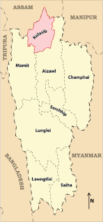
Kolasib district is one of the eight districts of Mizoram state in India. It is the smallest district in Mizoram with an area of 1,386 km2(535 sq mi).

Atasu Dam is a concrete-face rock-fill dam on the Gaylan River, 16 km (10 mi) south of Trabzon in Trabzon Province, Turkey. It was built between 1998 and 2010 for the primary purpose of drinking water supply but also has a 5 MW hydroelectric power station.
Kığı Dam is a rock-fill embankment dam on the Peri River in Bingöl Province, Turkey. Its primary purpose is hydroelectric power generation and is the first dam in the Peri River cascade, serving as the headwaters. Construction began in 1998 and is backed by the Turkish State Hydraulic Works. When commissioned, it will support a 180 MW power station. Water from the reservoir will be diverted to an underground power station downstream via an 8.5 km (5.3 mi) long tunnel. In August 2015, suspected Kurdistan Workers' Party militants set fire to three cement trucks associated with the dam construction site. In January 2016, the dam was completed and the reservoir began to impound water.
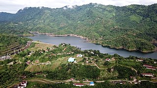
Tuirial dam is an earthfill and gravity dam near Kolasib in the state of Mizoram in India. The primary purpose of the dam is hydroelectric power production. The Cabinet Committee on Economic Affairs (CCEA) approved the 60 MW Tuirial Hydro Electric Project (THEP) project costing Rs 913 crore in 2010. The Project was Inaugurated by Narendra Modi on 16 December 2017.
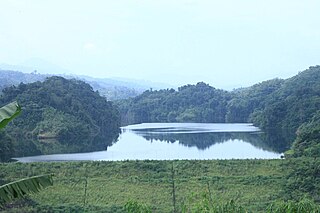
Serlui B dam, is an earthfill and gravity dam on the Serlui river 12 km from Bilkhawthlir Village near the Kolasib district in the state of Mizoram in India.
The Tlawng is a river of Mizoram, northeastern India. Its tributaries include the Tut, Teirei and the Ngashih. The city of Aizawl lies in the Tlawng valley.
The Teirei is a river of Mizoram, northeastern India, a tributary of the Tlawng River.
The Chhimtuipui river, also known as the Chhimmtuipi Lui or Kaladan river, is a river of Mizoram, northeastern India. It flows in a southerly direction through Myanmar.
The Tut is a river of Mizoram, northeastern India. It is a tributary of the Tlawng River.
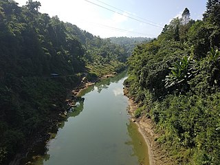
Bairabi Dam is a proposed 80 MW dam on the Tlawng river near Bairabi Village in Kolasib district in the state of Mizoram in India.
Mizoram is a land of rolling hills, valleys, rivers and lakes. As many as 21 major hills ranges or peaks of different heights run through the length and breadth of the state, with plains scattered here and there. The average height of the hills to the west of the state are about 1,000 metres. These gradually rise up to 1,300 metres to the east. Some areas, however, have higher ranges which go up to a height of over 2,000 metres.
Mizoram is one of the fastest growing economies among the states of India with a per capital income of Rs 50,021. Mizoram had the second highest GSDP growth during the 11th Five Year Plan (2007–2012) in Northeast India at 11% exceeding the target of 7.8% which is also much higher than the national average of 7.9%. During the 10th Five Year Plan (2002–2007), the Gross State Domestic Product (GSDP) was expected to grow at around 5.3% but grew at 5.7%. The biggest contributors to GSDP growth are Agriculture, Public Administration and Construction work. Tertiary sector of service sector continued to have the contribution to the GSDP with its share hovering between 58% and 60% during the past half a decade.
The Artvin Dam an arch-gravity dam on the Çoruh River in Artvin Province, Turkey. Preliminary construction on the dam began in December 2010 and the river diversion tunnels were complete in July 2012 at which time construction on the dam foundation started. The purpose of the dam is hydroelectric power generation and its power station has an installed capacity of 340 MW when completed. The dam is part of the Çoruh Development Plan and its construction was supervised by Turkey's State Hydraulic Works. The dam began to impound its reservoir in October 2015 and the power station was commissioned beginning in January 2016.
The Lungleng river, also known as the Lungleng Lui, is a river of Mizoram, northeastern India. It flows in a southerly direction towards Myanmar.


