Related Research Articles

Mizoram is a state in Northeast India, with Aizawl as its seat of government and capital city. The name of the state is derived from "Mizo", the self-described name of the native inhabitants, and "Ram", which in the Mizo language means "land." Thus "Mizo-ram" means "land of the Mizos". Within India's northeast region, it is the southernmost landlocked state, sharing borders with three of the Seven Sister States, namely Tripura, Assam and Manipur. The state also shares a 722-kilometre (449 mi) border with the neighbouring countries of Bangladesh and Myanmar.

Lunglei is a town, situated in the south-central part of Mizoram state, northeastern India. Lunglei, literally meaning 'bridge of rock' got its name from a bridge like rock found in the riverine area around Nghasih - a small tributary of Tlawng the longest river in Mizoram. It is the largest town after the capital, Aizawl, located 165 km (102 miles) south of Aizawl.
Sairang is a town in the Aizawl district of the Indian state of Mizoram.
The Ministry of Development of North Eastern Region is a Government of India ministry, established in September 2001, which functions as the nodal Department of the Central Government to deal with matters related to the socio-economic development of the eight States of Northeast India: Arunachal Pradesh, Assam, Manipur, Meghalaya, Mizoram, Nagaland, Tripura and Sikkim. It acts as a facilitator between the Central Ministries/ Departments and the State Governments of the North Eastern Region in the economic development including removal of infrastructural bottlenecks, provision of basic minimum services, creating an environment for private investment and to remove impediments to lasting peace and security in the North Eastern Region.
Lunglei district is one of the eleven districts of Mizoram state in India. As of 2011 it is the second most populous district in the state, after Aizawl. It is also the largest district in Mizoram with an area of 4,572 square kilometres (1,765 sq mi).
Serchhip District is one of the eleven districts of Mizoram state in India. The district occupies an area of 1421.60 km². Serchhip town is the administrative headquarters of the district. This district came into existence on 15 September 1998, being carved out of the larger Aizawl District. Because of the way it was created it includes part of East Lungdar Tehsil and part of Thingsulthliah Tehsil.
Lawngtlai district is one of the eleven districts of Mizoram state in India. The district is bounded on the north by Lunglei district, on the west by Bangladesh, on the south by Myanmar and on the east by Saiha district. The district occupies an area of 2557.10 km2. Lawngtlai town is the administrative headquarters of the district.

The Kaladan or Kissapanadi River, also known as the Beino, Bawinu and Kolodyne, is a river in eastern Mizoram State of India, and in Chin State and Rakhine State of western Myanmar. The Kaladan River is called the Chhimtuipui River in India. It forms the international border between India and Burma between 22° 47′ 10" N and 22° 11′ 06" N.

India–Myanmar relations, also knows as Indian–Burmese relations or Indian–Myanmar relations, are the bilateral relations between the Republic of India and the Republic of the Union of Myanmar. These relations encompass the political, economic and socio-cultural relations that exist between the two neighboring Asian countries. Political relations have improved considerably since 1993, overcoming tensions related to drug trafficking, the suppression of democracy and the rule of the military junta in Myanmar. Political leaders from both countries meet regularly on a bilateral basis and within the ASEAN Plus Six community. Economic relations are considerable with India representing Myanmar's 4th largest export market and the country's 5th largest import partner.
Lawngtlai is the district headquarters of Lawngtlai district in the state of Mizoram in India. It is also the headquarters of Lai Autonomous District Council, one of the three autonomous district councils in Mizoram.
Sittwe Port is a deepwater port constructed by India in 2016 at Sittwe, the capital of Rakhine State in Myanmar, on the Bay of Bengal. Situated at the mouth of the Kaladan River, the US$120 Million port is being financed by India as a part of the Kaladan Multi-Modal Transit Transport Project, a collaboration between India and Myanmar. The project is aimed at developing transport infrastructure in Southwestern Myanmar and Northeastern India.

The Kaladan Road Project is a US$484 million project connecting the eastern Indian seaport of Kolkata with Sittwe seaport in Rakhine State, Myanmar by sea. In Myanmar, it will then link Sittwe seaport to Paletwa in Chin State via the Kaladan river boat route, and then from Paletwa by road to Mizoram state in Northeast India. All components of the project, including Sittwe port and power, river dredging, Paletwa jetty, have been completed, except the under construction Zorinpui-Paletwa road. Originally, the project was scheduled to be completed by 2014, but end-to-end project is expected to be fully operational only by March 2023 as per March 2021 update.
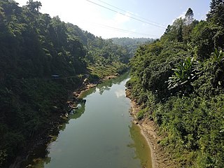
The Tlawng is a river of Mizoram, northeastern India. Its tributaries include the Tut, Teirei and the Ngashih. The city of Aizawl is situated to the east of the Tlawng river.
The Chhimtuipui river, also known as the Chhimmtuipi Lui or Kaladan river, is a river of Mizoram, northeastern India. It flows in a southerly direction through Myanmar.
Mizoram is a land of rolling hills, valleys, rivers and lakes in Northeast India. As many as 21 major hills ranges or peaks of different heights run through the length and breadth of the state, with plains scattered here and there. The average height of the hills to the west of the state are about 1,000 metres. These gradually rise up to 1,300 metres to the east. Some areas, however, have higher ranges which go up to a height of over 2,000 metres.

Zokhawthar is a border town in the Champhai district of Mizoram state of India. It is located in the Khawzawl R.D. Block, on the India–Myanmar border, near the Rih Dil lake.
Zochawchhuah, also spelt Zochachhuah, is a village on the India-Myanmar border in Lawngtlai Block of Lawngtlai district in the state of Mizoram in India. It is located 4 km south of the District headquarters Lawngtlai, 10 km from Hmawngbuchhuah, 157 km from the State capital Aizawl. It is on the east bank of the Sekulh Lui River, which marks the India-Myanmar border.
Hmawngbuchhuah is a village in Lawngtlai Block in Lawngtlai district in the state of Mizoram, India.
Katakhal is a town and railway station in Hailakandi tehsil of Hailakandi district in the Indian state of Assam. The village is named after the Katakhal River which originates in Bhairabi after three other rivers merge. The river ends at Kalinagar Village falling into Barak river. The Hailakandi district is one of the three districts of Southern Assam in the Barak Valley.
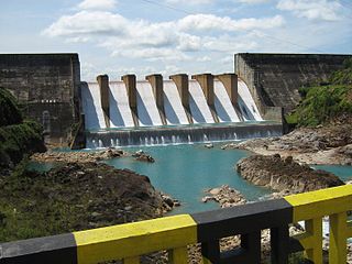
Kopili Hydro Electric Project is a 275 megawatts (369,000 hp), hydroelectric power project on the Kopili river and its tributary, Umrong stream. It is located in Dima Hasao district of Assam state in India. The project is developed and operated by North Eastern Electric Power Corporation Limited. It is an important project since the indian State of Assam, Arunachal Pradesh, Manipur, Meghalaya, Mizoram, Nagaland and Tripura benefit from this project.