Tokarowszczyzna, Białystok County

Last updated
Tokarowszczyzna
Village
Country Flag of Poland.svg  Poland
Voivodeship Podlaskie
County Białystok County
Gmina Michałowo

Tokarowszczyzna [tɔkarɔfʂˈt͡ʂɨzna] is a village in the administrative district of Gmina Michałowo, within Białystok County, Podlaskie Voivodeship, in north-eastern Poland, close to the border with Belarus. [1]

Village Small clustered human settlement smaller than a town

A village is a clustered human settlement or community, larger than a hamlet but smaller than a town, with a population ranging from a few hundred to a few thousand. Though villages are often located in rural areas, the term urban village is also applied to certain urban neighborhoods. Villages are normally permanent, with fixed dwellings; however, transient villages can occur. Further, the dwellings of a village are fairly close to one another, not scattered broadly over the landscape, as a dispersed settlement.

Gmina Michałowo Gmina in Podlaskie, Poland

Gmina Michałowo is an urban-rural gmina in Białystok County, Podlaskie Voivodeship, in north-eastern Poland, on the border with Belarus. Its seat is the town of Michałowo, which lies approximately 31 kilometres (19 mi) east of the regional capital Białystok.
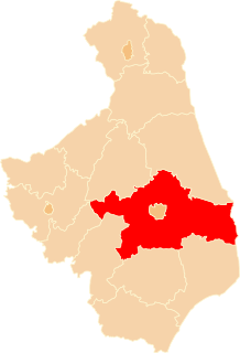
Białystok County County in Podlaskie, Poland

Białystok County is a unit of territorial administration and local government (powiat) in Podlaskie Voivodeship, north-eastern Poland, on the border with Belarus. It was created on 1 January 1999 as a result of the Polish local government reforms passed in 1998. Its administrative seat is the city of Białystok, although the city is not part of the county. The county contains nine towns: Łapy, 25 km (16 mi) south-west of Białystok, Czarna Białostocka, 22 km (14 mi) north of Białystok, Wasilków, 11 km (7 mi) north of Białystok, Choroszcz, 13 km (8 mi) west of Białystok, Supraśl, 16 km (10 mi) north-east of Białystok, Michałowo, 13 km (8 mi) east of Białystok, Zabłudów, 16 km (10 mi) south-east of Białystok, Tykocin, 29 km (18 mi) west of Białystok, and Suraż, 23 km (14 mi) south-west of Białystok.

Related Research Articles

Oldřišov is a village in the Moravian-Silesian Region of the Czech Republic. It is part of micro-region Hlučínsko. It has around 1,300 inhabitants.

Dolní Bezděkov Village in Chrudim District of Pardubice region

Dolní Bezděkov is a small village in the Pardubice Region of the Czech Republic, around 10 km south-east of the city of Pardubice. It has around 180 inhabitants.

Paul Lake Provincial Park is a provincial park in British Columbia, Canada, located southwest of Heffley Lake and to the northeast of the city of Kamloops.

Leroy No. 339, Saskatchewan is a rural municipality in central Saskatchewan, east of Saskatoon. Leroy No. 339 started out with the name Roach from January 1, 1913 until March 14, 1914 when the name changed to Ayr. Ayr remained the name after 1914 through until February 27, 1931 when it became Leroy No. 339.

Bordj Menaïel District District in Boumerdès, Algeria

Bordj Ménaïel is a district in Boumerdès Province, Algeria. It was named after its capital, Bordj Menaïel.

Wymyślin Village in Kuyavian-Pomeranian, Poland

Wymyślin is a village in the administrative district of Gmina Kikół, within Lipno County, Kuyavian-Pomeranian Voivodeship, in north-central Poland. It lies approximately 6 kilometres (4 mi) north-west of Kikół, 14 km (9 mi) north-west of Lipno, and 33 km (21 mi) east of Toruń.

Gąsówka-Oleksin is a village in the administrative district of Gmina Łapy, within Białystok County, Podlaskie Voivodeship, in north-eastern Poland.

Zaleszany, Białystok County Village in Podlaskie, Poland

Zaleszany is a village in the administrative district of Gmina Michałowo, within Białystok County, Podlaskie Voivodeship, in north-eastern Poland, close to the border with Belarus. It lies approximately 24 kilometres (15 mi) east of Michałowo and 54 km (34 mi) east of the regional capital Białystok.

Gibasówka, is a village in the administrative district of Gmina Giby, within Sejny County, Podlaskie Voivodeship, in north-eastern Poland, close to the borders with Belarus and Lithuania.

Dəmirli Place in Tartar, Azerbaijan

Dəmirli is a village in the Tartar Rayon of Azerbaijan.

Brzozówka, Poddębice County Village in Łódź, Poland

Brzozówka is a village in the administrative district of Gmina Uniejów, within Poddębice County, Łódź Voivodeship, in central Poland. It lies approximately 11 kilometres (7 mi) north of Uniejów, 24 km (15 mi) north-west of Poddębice, and 59 km (37 mi) north-west of the regional capital Łódź.

Drewnowo-Lipskie is a village in the administrative district of Gmina Boguty-Pianki, within Ostrów Mazowiecka County, Masovian Voivodeship, in east-central Poland.

Klukowo, Pułtusk County Village in Masovian, Poland

Klukowo is a village in the administrative district of Gmina Świercze, within Pułtusk County, Masovian Voivodeship, in east-central Poland. It lies approximately 24 kilometres (15 mi) west of Pułtusk and 53 km (33 mi) north of Warsaw.

Smolno Małe is a village in the administrative district of Gmina Kargowa, within Zielona Góra County, Lubusz Voivodeship, in western Poland.

Wysoka, West Pomeranian Voivodeship Village in West Pomeranian, Poland

Wysoka is a village in the administrative district of Gmina Boleszkowice, within Myślibórz County, West Pomeranian Voivodeship, in north-western Poland, close to the German border. It lies approximately 5 kilometres (3 mi) north-east of Boleszkowice, 28 km (17 mi) south-west of Myślibórz, and 75 km (47 mi) south of the regional capital Szczecin.

Falun, Alberta

Falun is a hamlet in central Alberta, Canada within the County of Wetaskiwin No. 10. It is located on Highway 13, approximately 31 kilometres (19 mi) west of Wetaskiwin.

Maamora is a town and commune in Bouïra Province, Algeria. According to the 1998 census it has a population of 3,569.

Nippes, Cologne 5th District of Cologne in North Rhine-Westphalia, Germany

Nippes is the fifth city district of Cologne, Germany. Nippes was incorporated into the city of Cologne in 1888 and the district was created in 1975. A large Ford Europe production plant is located in Niehl, the north-eastern part of the district.

Höwenegg is a mountain of Baden-Württemberg, Germany.

Toplica is a village in Municipality of Prilep, Republic of Macedonia.

References


Coordinates: 52°57′30″N23°44′30″E / 52.95833°N 23.74167°E / 52.95833; 23.74167

Geographic coordinate system Coordinate system

A geographic coordinate system is a coordinate system that enables every location on Earth to be specified by a set of numbers, letters or symbols. The coordinates are often chosen such that one of the numbers represents a vertical position and two or three of the numbers represent a horizontal position; alternatively, a geographic position may be expressed in a combined three-dimensional Cartesian vector. A common choice of coordinates is latitude, longitude and elevation. To specify a location on a plane requires a map projection.