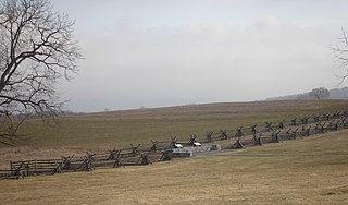
Antietam National Battlefield is a National Park Service protected area along Antietam Creek in Sharpsburg, Washington County, northwestern Maryland. It commemorates the American Civil War Battle of Antietam that occurred on September 17, 1862.

The Baltimore and Ohio Railroad Crossings at the Potomac River are a set of railroad bridges that span the Potomac River between Maryland Heights, Maryland and Harpers Ferry, West Virginia in the United States.

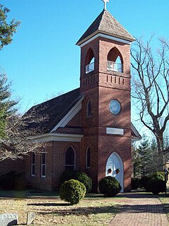
St. Ignatius Church is a Roman Catholic parish church of the Archdiocese of Washington located at 2317 Brinkley Rd., Oxon Hill, in Prince George's County, Maryland. The historic church structure was constructed between 1890 and 1891, and partially funded by Mary Surratt, one of the conspirators involved with the Assassination of Abraham Lincoln. The 1 1⁄2-story structure is wood frame, with clapboarding, and shingling in imbricated pattern. It is rectangular in form with a gabled roof, 80-foot (24 m) projecting front belfry with spire and louvered openings, round arched openings, and modified corner buttresses. The architectural style is considered Eclectic, with elements of the Shingle and Queen Anne styles. It is the second church on site and has served as a mission and parish church.

St. Matthew's Church, also known as Addison Chapel, is a historic Episcopal church located at Seat Pleasant, Prince George's County, Maryland. Although the current chapel was built about 1809, its simple Anglican styling reflects the Colonial-era, Church of England-influenced designs, of which few remain. Addison Chapel was first established in 1696 as a chapel of ease for St. John's at Broad Creek. The parish it serves was one of the thirty original Maryland parishes and was named for Colonel John Addison, of Oxon Hill plantation, a leading proponent of the Anglican Church. His descendant Walter Dulaney Addison, who was for a term Chaplain of the Senate also served as rector here. The church is a small one-story rectangular brick building laid in Flemish bond. It is associated with the Pinkney, Dulany, Addison, Lowndes, and Calvert families. St. Matthew's is situated in a large graveyard containing some early stones, the most notable being that of Benjamin Stoddert, the first Secretary of the Navy.
St. Thomas' Church is a historic brick church in a picturesque rural setting, located at Croom, Prince George's County, Maryland. The original church was constructed between 1742 and 1745, and is one of the earliest Episcopal churches in Southern Maryland.

Middleham Chapel is an historic Episcopal church located at 10210 H. G. Trueman Road in Lusby, Calvert County, Maryland. It is a one-story, cruciform, Flemish bond brick structure with exposed fieldstone foundations. It was built in 1748, to replace an earlier frame or log structure believed to have been erected as early as 1684, as a Chapel of Ease of Christ Church Parish. The date of construction is worked into the brick on the front of the church.
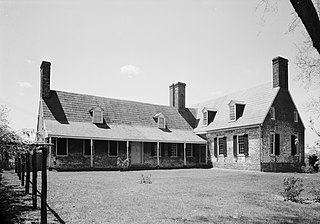
Holly Hill, also known as Holland's Hills or Rose Valley, is a historic house at Friendship, Anne Arundel County, Maryland, United States.

St. Ignatius Roman Catholic Church is a historic Roman Catholic church located at St. Inigoes, St. Mary's County, Maryland. It and its adjacent cemetery are situated on about two acres of land that are enclosed within a late 19th-century iron fence. The church was constructed between 1785 and 1787, with the sacristy added in 1817. The church walls are 21 inches thick, of brick laid in Flemish bond. Atop the roof is a small wooden belfry that in 1933 replaced a larger one in this same location.

Charlotte Hall Historic District is a national historic district in Charlotte Hall, St. Mary's County, Maryland. It encompasses a small village along "Old Route 5." It includes 13 recorded buildings and sites of historic and/or architectural interest as well as the main campus of the Charlotte Hall Military Academy.

St. Francis Xavier Church and Newtown Manor House Historic District is the first county designated historic district in Saint Mary's County, the "Mother County" of Maryland and is located in Compton, Maryland, near the county seat of Leonardtown. The district marks a location and site important in the 17th century ecclesiastical history of Maryland, as an example of a self-contained Jesuit community made self-supporting by the surrounding 700-acre (2.8 km2) farm. The two principal historic structures were added to the National Register of Historic Places in 1972. Archaeological remains associated with the site date back to the early colonial period, mid-17th century.
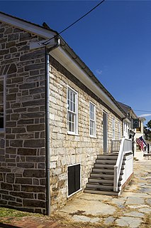
The Good-Reilly House is a historic home located at Sharpsburg, Washington County, Maryland, United States. It is located at the northeast corner of the town square and is a 1 1⁄2-story stone house with combined Maryland colonial and Georgian stylistic influence. The house likely dates from the 1780s, and features flush stone chimneys on each gable end.

Wilson–Miller Farm is a historic home and farm located near Sharpsburg, Washington County, Maryland, United States. The house is a two-story, two-part, eight-bay log building resting on fieldstone foundations. The house features three brick chimneys, each painted red. Outbuildings include a one-story stone springhouse and a frame bank barn.
The William Hagerman Farmstead is a historic home located at Sharpsburg, Washington County, Maryland, United States. The house is a 2 1⁄2-story five-bay brick dwelling with a raised cellar. It features a double porch, three tiered, extending across the east gable end of the house. The house is an exceptionally intact example of an 1860s vernacular interpretation of the Italianate architecture.

Hoffman Farm is a historic farm complex located at Keedysville, Washington County, Maryland, United States. It consists of an 1840s Greek Revival style two-story brick dwelling, adjacent brick slave quarters, a Federal-style stone house built about 1810 over a spring, a frame wagon shed, a log hog barn, and a frame forebay bank barn. The farm buildings were used as a hospital during the American Civil War in Battle of Antietam from the day of the battle on September 17, 1862, and through the following month. Over 800 men were hospitalized in the barn, house, outbuildings, and grounds.
Mount Airy, also known as Grove Farm, is a historic home located at Sharpsburg, Washington County, Maryland, United States. It is a 2 1⁄2-story Flemish bond brick house, built about 1821 with elements of the Federal and Greek Revival styles. Also on the property are a probable 1820s one-story gable-roofed brick structure that has been extensively altered over time, a late-19th-century frame barn with metal roof ventilators, a 2-story frame tenant house built about 1900, and a mid-20th-century cinder block animal shed. It was used as a hospital for Confederate and Union soldiers following the Battle of Antietam. On October 3, 1862, President Abraham Lincoln and General George McClellan visited Mount Airy, an event recorded photographically by Alexander Gardner.
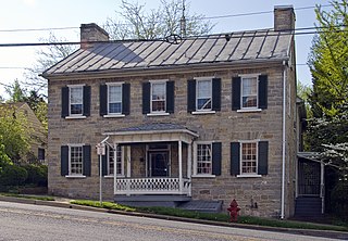
The Piper House is a historic home located at the southeast corner of Main and Church Streets in Sharpsburg, Washington County, Maryland, United States. It has a two-story limestone main block, constructed between 1792 and 1804, with a two-story brick wing, added about 1834. The house features a hip-roofed porch that shelters the main central entrance.

Hitt's Mill and Houses, also known as Pry's Mill, Valley Mills, Hitt House, is a historic home and mill complex located at Keedysville, Washington County, Maryland, United States. It is a five-story stone and brick structure built as a grist mill. The ground story and the first full story above ground level are constructed of coursed limestone; the upper stories are built of brick. Also on the property is a square log outbuilding with a hipped roof, a large frame bank barn, and part of a fieldstone barnyard fence. The mill and the Hitt house served as hospitals during and after the nearby Civil War Battle of Antietam.

Wilson's Bridge is a bridge near Hagerstown, Washington County, Maryland, United States. It originally carried the Hagerstown and Conococheague Turnpike, the National Road, across Conococheague Creek 7 miles (11 km) west of Hagerstown. The five-arched structure, the longest of the county's stone bridges, is 210 feet (64 m) in length and is constructed of coursed local limestone. The bridge was erected in 1819 by Silas Harry, who had built similar bridges in Pennsylvania. The bridge was closed in June 1972 when it was damaged by floods which occurred during Tropical Storm Agnes.
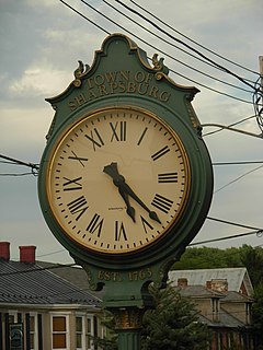
Sharpsburg Historic District is a national historic district located at Sharpsburg, Washington County, Maryland.

St. Thomas' Episcopal Parish Historic District is a national historic district located at Croom, Prince George's County, Maryland. The district encompasses four contributing buildings and three contributing sites associated with St. Thomas' Church. The other contributing buildings are the Gothic Revival style St. Thomas' Church Rectory (1852-1853), Tenant/Sexton's House, and tobacco barn. The contributing sites are the St. Thomas' Episcopal Church Cemetery, St. Simon's Mission Chapel Site, and St. Simon's Cemetery. The African-American communicants of St. Thomas' Church formed St. Simon's Mission Chapel in the late-19th century and it operated on the property associated with the Croome Industrial and Agricultural School, which operated from about 1902 to 1952.