Kaipara Harbour is a large enclosed harbour estuary complex on the north western side of the North Island of New Zealand. The northern part of the harbour is administered by the Kaipara District and the southern part is administered by the Auckland Council. The local Māori tribe is Ngāti Whātua.

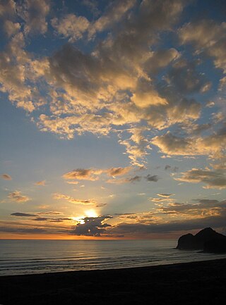
Muriwai, also called Muriwai Beach, is a coastal community on the west coast of the Auckland Region in the North Island of New Zealand. The black-sand surf beach and surrounding area is a popular recreational area for Aucklanders. The Muriwai Regional Park includes a nesting site for a large colony of gannets.

Wellsford is a town on the Northland Peninsula in the northern North Island of New Zealand. It is the northernmost major settlement in the Auckland Region, and is 77 kilometres (48 mi) northwest of the Auckland CBD. It is a major regional centre, being located at the junction of State Highways 1 and 16, almost halfway between Auckland and the Northland city of Whangārei.
Te Henga, or Bethells Beach, is a coastal community in West Auckland, New Zealand. The Māori name for the area, "Te Henga", is in reference to the long foredunes which run along the beach and look like the Henga or gunwale of an upturned waka hull. This name originally applied to a wide area of the lower Waitakere River valley, but during the early 1900s the area became popular with visiting European immigrants who began to refer to the area as "Bethells Beach" after the Bethell Family who live there and still own much of the area. In 1976 the New Zealand Geographic Board officially named the area "Te Henga ".

Te Ārai is a small community on the east coast of the North Island of New Zealand, near the northern end of the Auckland Region. Mangawhai lies to the north, and Tomarata to the south. The name of the suburb comes from Tāhuhunui-o-te-rangi, captain of the Moekākara waka, who landed here and set up a temporary shelter (arai). Tāhuhunui-o-te-rangi was later buried at Te Ārai.
Pākiri is a locality in Auckland, in the former Rodney District of New Zealand. Leigh is about 9 kilometres (6 mi) to the south-east. The Pākiri River flows through the area and into the Hauraki Gulf / Tīkapa Moana to the north-east.

Tomarata is a locality in the Auckland Region of New Zealand. Wellsford lies to the south-west, Te Ārai to the north, and Pākiri to the south-east. Tomarata Lake is nearby and is popular for boating, water skiing, kayaking and swimming. It is also used as a place to picnic and has a trail that follows the edge of the lake for hiking.
Lake Wainamu is a small lake near Te Henga in the Auckland Region of New Zealand. It is located south-west of Lake Kawaupaka.

Lake Kawaupaka, also known as Lake Kawaupaku, is a small lake near Te Henga in the Auckland Region of New Zealand. The lake is on private land, and is one of the few dune lakes in the region to be surrounded by native forest. It is located south-west of Lake Wainamu.

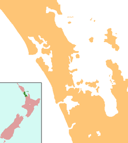
Rodney Local Board is one of the 21 local boards of Auckland Council, and is administered by the ward councillor representing Rodney Ward. Located in the northern part of the Auckland region, it is named after the former Rodney District which existed before its amalgamation into Auckland Council in 2010. Nine elected Local Board members sit on the board.

Lake Rototoa is located at the northern end of the south head of the Kaipara Harbour in the Rodney ward of the Auckland Region, New Zealand. With a surface area of 1.39 km2 and a maximum depth of 26 m, it is the largest and deepest of a series of sand-dune lakes found along the western coastline of the North Island.

The Whangamarino Wetland in the Waikato District is the second largest wetland complex of the North Island of New Zealand. Encompassing a total area of more than 7200 hectares, the Department of Conservation Te Papa Atawhai manages 5,923 hectares of peat bog, swamp, mesotrophic lags, open water and river systems listed as a wetland of international importance under the Ramsar Convention. Fish and Game New Zealand are the second largest landowner, managing 748 hectares of the wetland primarily as gamebird hunting habitat.

Muriwai Regional Park is a regional park located in Muriwai on the west coast of the Auckland Region of New Zealand's North Island. It is situated in Rodney north-west of Auckland and is owned and operated by Auckland Council.

Ātiu Creek Regional Park is a regional park located south of Oruawharo River in the Kaipara Harbour in New Zealand's North Island. It is located west of Wellsford and east of Tapora on the Okahukura Peninsula, in Rodney in the Auckland Region and is run by Auckland Council.
Te Ārai Regional Park is a regional park situated in the Auckland Region of New Zealand's North Island. It is owned and operated by Auckland Council.
The Kai Iwi Lakes are located in Taharoa Domain in the Northland region of New Zealand. The reserve encompasses a series of three freshwater dune lakes: Lake Taharoa, Lake Kaiiwi, and Lake Waikare, sometimes called Lake Waikere.
Slipper Lake is a lake at Te Ārai, Rodney in the northern Auckland Region of New Zealand.

Spectacle Lake is a lake at Te Ārai, Rodney in the northern Auckland Region of New Zealand.

Manukapua Island, also known as Sand Island or Big Sand Island, is an island located in the Kaipara Harbour in the Auckland Region, New Zealand, near Tāpora on the Okahukura Peninsula.