Karlskrona Municipality is a municipality in Blekinge County in South Sweden in southern Sweden. It borders to Emmaboda Municipality, Torsås Municipality and Ronneby Municipality. The city of Karlskrona is the seat of the municipality.

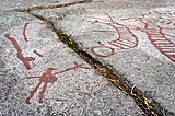
A petroglyph is an image created by removing part of a rock surface by incising, picking, carving, or abrading, as a form of rock art. Outside North America, scholars often use terms such as "carving", "engraving", or other descriptions of the technique to refer to such images. Petroglyphs, estimated to be 20,000 years old and classified as protected monuments and have been added to the tentative list of UNESCO’s world heritage sites. Petroglyphs are found worldwide, and are often associated with prehistoric peoples. The word comes from the Greek prefix petro-, from πέτρα petra meaning "stone", and γλύφω glýphō meaning "carve", and was originally coined in French as pétroglyphe.

Ronneby is a locality and the seat of Ronneby Municipality in Blekinge County, Sweden with 12,029 inhabitants in 2010.

Karlskrona is a locality and the seat of Karlskrona Municipality, Blekinge County, Sweden with a population of 66,675 in 2018. It is also the capital of Blekinge County. Karlskrona is known as Sweden's only baroque city and is host to Sweden's largest naval base and the headquarters of the Swedish Coast Guard.

Hasslö is an island and a locality situated in the Blekinge archipelago in Karlskrona Municipality, Blekinge County, Sweden with 1,628 inhabitants in 2010.
Sturkö is a locality located on the island Sturkö in Karlskrona Municipality, Blekinge County, Sweden with 1,264 inhabitants in 2010.

Kristianopel is a village in Karlskrona Municipality in the southeastern Swedish region of Blekinge. In 2015 it had a population of 88.

Jämjö is a locality situated in Karlskrona Municipality, Blekinge County, Sweden with 2,578 inhabitants in 2010.
Fågelmara is a locality situated in Karlskrona Municipality, Blekinge County, Sweden with 374 inhabitants in 2010.
Fridlevstad is a locality situated in Karlskrona Municipality, Blekinge County, Sweden with 713 inhabitants in 2010.
Gängletorp is a locality situated in Karlskrona Municipality, Blekinge County, Sweden with 369 inhabitants in 2010.
Holmsjö is a locality situated in Karlskrona Municipality, Blekinge County, Sweden with 334 inhabitants in 2010.
Kättilsmåla is a locality situated in Karlskrona Municipality, Blekinge County, Sweden with 253 inhabitants in 2010.
Nävragöl is a locality situated in Karlskrona Municipality, Blekinge County, Sweden with 210 inhabitants in 2010.
Rödeby is a locality situated in Karlskrona Municipality, Blekinge County, Sweden with 3,402 inhabitants as of 2010. It is located about 12 kilometers north of Karlskrona.
Skavkulla och Skillingenäs is a locality situated in Karlskrona Municipality, Blekinge County, Sweden, with 621 inhabitants in 2010.
Spjutsbygd is a locality situated in Karlskrona Municipality, Blekinge County, Sweden with 383 inhabitants in 2010.
Tving is a locality situated in Karlskrona Municipality, Blekinge County, Sweden with 459 inhabitants in 2010.
Sjuhalla is a locality situated in Karlskrona Municipality, Blekinge County, Sweden with 204 inhabitants in 2010.
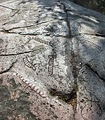
The Rock art in Sweden is the richest artistic material from the north of prehistoric Europe. Older scholarship mostly saw it as evidence for the religious practices of the Nordic Bronze Age. Newer research sees the art not only as depictions of cultic rituals but also as source material for cultural history and social hierarchies. The production of rock art required significant effort, so they must have had important meaning for their creators. Regional variations show that local populations, not travelling artists, were responsible for them.
 Rock carvings at Hästahallen