
Valle San Giovanni is a small village in the province of Teramo, in the Abruzzo region of central Italy. It is a frazione of the town of Teramo.

The province of Teramo is a province in the Abruzzo region of Italy. Its capital is the city of Teramo. The province has an area of 1,948 square kilometres (752 sq mi), a population of 313,029 (2012), and is subdivided into 47 comuni, see comunes of the province of Teramo. The province of Teramo shares its northern border with the province of Ascoli Piceno in the Marche region, southern and southwestern borders with the province of L'Aquila in the Abruzzo region, and a western border with the province of Rieti in the Lazio region. To the south is the province of Pescara in the Abruzzo region and to the east is the Adriatic Sea.

Teramo is a city and comune in the Italian region of Abruzzo, the capital of the province of Teramo.
Poggio is an Italian word meaning "knoll". It may refer to:
Veroli is a town and comune in the province of Frosinone, Lazio, central Italy, in the Latin Valley.
Villa Popolo is a small village in the province of Teramo, in the Abruzzo region of central Italy. It is a frazione of the comune of Torricella Sicura.

Torricella Peligna is a comune and town in the Province of Chieti in the Abruzzo region of Italy.

Civitella Casanova is an Italian town of inland mountain of 1,950 inhabitants in the province of Pescara in Abruzzo and belongs to the mountain community Vestina. Listed on the National Park of Gran Sasso and Monti della Laga and the Regional Reserve Voltigno and Valle d'Angri, a regional reserve included in the National Park, the country bases its economy mainly on agriculture. It has pre-Roman origins of repute, the sources of the historian Livy emerges as the town of Civitella was called Cutina or Cingilia.

Campli is a town and comune in the province of Teramo, in the Abruzzo region of central Italy. It is located in the natural park known as the Gran Sasso e Monti della Laga National Park. It is one of I Borghi più belli d'Italia.

Crognaleto is a comune and city of slightly less than 2,000 people in the Province of Teramo, central Italy. Crognaleto sits at an elevation of 1,105 metres (3,625 ft) and has its communal administrative offices in the frazione of Nerito. The commune of Crognaleto sits on the slopes of the Monti della Laga mountain range and extends across both the northern and the southern slopes of the Vomano Valley. It lies within the Gran Sasso e Monti della Laga National Park.
Valle Castellana is a village and comune in the Province of Teramo, in the Abruzzo region of central Italy. It is a member of the Italian community of surrounding mountain villages, Monti della Laga. It is located in the natural park known as the Gran Sasso e Monti della Laga National Park.

Poggio Mirteto is a comune (municipality) is situated in the Tiber Valley Central Italian region of Latium. Administratively Poggio Mirteto is in the province of Rieti and geographically this municipality is about 45 kilometres (28 mi) northeast of Rome and about 20 kilometres (12 mi) southwest of Rieti.
Sgurgola is a comune (municipality) in the Province of Frosinone in the Italian region Lazio, located about 60 kilometres (37 mi) southeast of Rome and about 15 kilometres (9 mi) west of Frosinone.
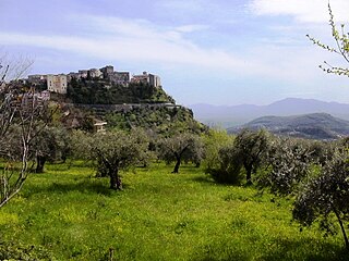
Poggio Sannita is a comune (municipality) in the Province of Isernia in the Italian region Molise, located about 30 kilometres (19 mi) northwest of Campobasso and about 25 kilometres (16 mi) northeast of Isernia. Poggio Sannita is on a promontory surrounded by the Verrino and Sente rivers, both mostly torrential in character, especially the latter, which dries up completely during the summer.

Valle Piola is a deserted village in the province of Teramo, in the Abruzzo region of central Italy. It is a frazione of the comune of Torricella Sicura. Having been abandoned in 1977, all that remains are 9 abandoned houses, a church, and the ruins of a shepherds' shelter. The village has recently received renewed interest from the Gran Sasso and Monti della Laga National Park authorities with the aim of restoring and revitalizing the village and its environs.

The Gran Sasso and Monti della Laga National Park is a natural park in central Italy. Established in 1991, it covers an area of 2,014 square kilometres (778 sq mi), mostly within the provinces of Teramo, L'Aquila, and Pescara in Abruzzo, with small areas in the provinces of Rieti in Lazio and Ascoli Piceno in Marche. The terrain is predominantly mountainous with alpine plains.
Costumi is a frazione—a small hamlet—located in the commune of Torricella Sicura in the Italian Province of Teramo. The origins of the name date back to feudal times and refer to the usual and customary contributions ('costumi') that the denizens were expected to forward to the baronial landowners. The Costumarii were the local townsmen entrusted with this act.
Magliano is a village in the Italian region of Abruzzo. It is a frazione of the comune of Torricella Sicura, in the Province of Teramo.
Ioanella is a frazione of the Commune of Torricella Sicura in the Province of Teramo, Italy.
Colle Caruno is a frazione of the Commune of Teramo in the Abruzzo Region of Italy. It is located about four miles from the communal capital. In times past the village has been referred to in documents as Colacaruni or Collecaruni. These names likely derive from a certain Cola (Niccola) Caruni, buried in a graveyard in Teramo.


