Jan Mayen is a Norwegian volcanic island in the Arctic Ocean, with no permanent population. It is 55 km (34 mi) long (southwest-northeast) and 373 km2 (144 sq mi) in area, partly covered by glaciers. It has two parts: larger northeast Nord-Jan and smaller Sør-Jan, linked by a 2.5 km (1.6 mi) wide isthmus. It lies 600 km (370 mi) northeast of Iceland, 500 km (310 mi) east of central Greenland and 1,000 km (620 mi) west of the North Cape, Norway. The island is mountainous, the highest summit being the Beerenberg volcano in the north. The isthmus is the location of the two largest lakes of the island, Sørlaguna, and Nordlaguna. A third lake is called Ullerenglaguna. Jan Mayen was formed by the Jan Mayen hotspot.

The Western Hemisphere is the half of Earth which lies west of the prime meridian and east of the antimeridian. The other half is called the Eastern Hemisphere. In geopolitical terms, the context in which the term is most often used, the Encyclopedia Britannica defines it as "North and South America and the surrounding waters. Longitudes 20°W and 160°E are often considered its boundaries." It may be used in a cultural or geopolitical sense as a synonym for the "New World".
Vulkaneifel is a district (Kreis) in the northwest of the state Rhineland-Palatinate, Germany. It is the least densely populated district in the state and the fourth most sparsely populated district in Germany. The administrative centre of the district is in Daun. Neighboring districts are Euskirchen, Ahrweiler, Mayen-Koblenz, Cochem-Zell, Bernkastel-Wittlich, and Bitburg-Prüm.

Svalbard and Jan Mayen is a statistical designation defined by ISO 3166-1 for a collective grouping of two remote jurisdictions of Norway: Svalbard and Jan Mayen. While the two are combined for the purposes of the International Organization for Standardization (ISO) category, they are not administratively related. This has further resulted in the country code top-level domain .sj being issued for Svalbard and Jan Mayen, and ISO 3166-2:SJ. The United Nations Statistics Division also uses this code, but has named it the Svalbard and Jan Mayen Islands.
Ormont-Dessous is a municipality of the canton of Vaud in Switzerland, located in the district of Aigle.

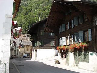
Ormont-Dessus is a municipality of the canton of Vaud in Switzerland, located in the district of Aigle.
.sj is the Internet country code top-level domain (ccTLD) reserved for the designation Svalbard and Jan Mayen. The domain name registry is Norid, but .sj is not open for registration. The issuing of the domain was based on the ISO 3166 designation of Svalbard and Jan Mayen, which consists of two separately administrated integrated territories of Norway: the Arctic archipelago Svalbard and the nearly uninhabited volcanic island Jan Mayen. .sj was designated on 21 August 1997, at the same time as Bouvet Island was allocated .bv. Both were placed under the .no registry Norid, which is also the sponsor. Norwegian policy states that .no is sufficient for those institutions connected to both Svalbard and Jan Mayen, and therefore the domain is not open to registration. It is Norwegian policy not to commercialize domain resources, so there are no plans to sell .sj. Should the domain later come into use, it will be under regulation of the Norwegian Post and Telecommunications Authority and follow the same policy as .no. There are two second-level domains reserved for the two areas: svalbard.no and jan-mayen.no, but other web addresses are also used.

Mayen is a town in the Mayen-Koblenz District of the Rhineland-Palatinate Federal State of Germany, in the eastern part of the Volcanic Eifel Region. As well as the main town, additional settlements include Alzheim, Kürrenberg, Hausen-Betzing, Hausen and Nitztal. Mayen is the administrative centre of the Vordereifel ‘Collective Municipality’, although it is not part of the municipality.

Vallendar is a town in the district Mayen-Koblenz, in Rhineland-Palatinate, Germany. It is situated on the right bank of the Rhine, approx. 4 km north-east of Koblenz. Vallendar is the seat of the Verbandsgemeinde Vallendar.
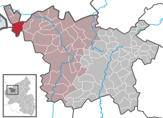
Ormont is an Ortsgemeinde situated in the Vulkaneifel district in Rhineland-Palatinate, Germany. It belongs to the Verbandsgemeinde of Gerolstein, whose seat is in the municipality of Gerolstein.

Assenay is a commune in the Aube department in the Grand Est region of north-central France.

The Jan Mayen Microcontinent is a fragment of continental crust within the oceanic part of the western Eurasian Plate lying northeast of Iceland. At the onset of separation between the Greenland and Eurasian plates 55 million years ago, it formed part of the eastern margin of the Greenland Plate. Propagation of a new spreading center from the Reykjanes Ridge separated this microcontinent from the Greenland Plate. For a short period it formed a microplate, until the Aegir Ridge became inactive, after which it formed part of the Eurasian Plate. The island of Jan Mayen is a much younger feature, formed of volcanic rock, built up at the northernmost tip of the microcontinent.

The Tour d'Aï is a mountain in the western Bernese Alps, overlooking Leysin in the canton of Vaud. It is located near the Tour de Mayen, on the range lying between the Rhone and Col des Mosses, south of Lake Geneva, from where both summits can be easily seen.

Pic Chaussy is a mountain of the Bernese Alps, overlooking Les Diablerets to the south. On its northern side lies the Lac Lioson, whilst the Col des Mosses pass flanks its western side. To the east, a ridgeline connects to the peaks of the Châtillon and Le Tarent. Its summit reaches an altitude of 2,351 metres (7,713 ft).

ISO 3166-2:SJ is the entry for Svalbard and Jan Mayen in ISO 3166-2, part of the ISO 3166 standard published by the International Organization for Standardization (ISO). The standard defines codes for names of principal subdivisions of all countries coded in ISO 3166-1. Svalbard and Jan Mayen does not exist as an administrative region, but rather consists of two separate parts of Norway under separate jurisdictions—Svalbard and Jan Mayen. Further subdivision for Svalbard and Jan Mayen occurs under Norway's entry, ISO 3166-2:NO, namely NO-21 for Svalbard and NO-22 for Jan Mayen. There are currently no ISO 3166-2 codes for Svalbard and Jan Mayen.

"Judgment Day" is an apocalyptic science fiction story by American writer L. Sprague de Camp. It was first published in the magazine Astounding Science Fiction for August, 1955, and first appeared in book form in the anthology The Best Science Fiction Stories and Novels: 1956. It later appeared in the de Camp collections A Gun for Dinosaur and Other Imaginative Tales, and The Best of L. Sprague de Camp, as well as the anthologies Great Science-Fiction, A Science Fiction Argosy, and Masters of Darkness III. The story has also been translated into German.

The Gros Van is a mountain of the Swiss Prealps, overlooking the Col des Mosses in the canton of Vaud. It lies on the range between the Lac de l'Hongrin and the valley of Ormont-Dessous.

Mont d'Or is a mountain of the Bernese Alps of Switzerland, overlooking Le Sépey in the canton of Vaud. It lies on the range between the Lac de l'Hongrin and the valley of Ormont-Dessous, and flanks the Col des Mosses pass.

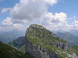
The Tour de Famelon is a mountain of the Swiss Prealps, located north of Leysin in the canton of Vaud. It lies between the Tour de Mayen and the Pierre du Moëllé, on the range lying between the lake of Hongrin and the valley of Ormont Dessous and Ormont Dessus.

The Booser Doppelmaar comprises two maars that have silted up and, today, form shallow depressions in the countryside. They lie on the territory of the village of Boos, a few hundred metres west of the village itself. The two maars were formed 10,150 to 14,160 years ago and belong to the Quaternary volcano field of the Volcanic Eifel. From a natural region perspective it lies in the south of the Hohe Acht Upland, ca. 7.8 km south of the summit of the Hohe Acht.