Related Research Articles

Washington County is a county in the U.S. state of Nebraska. As of the 2010 United States Census, the population was 20,234. Its county seat is Blair.

Burt County is a county in the U.S. state of Nebraska, bordering the west bank of the upper Missouri River. As of the 2010 United States Census, the population was 6,858. Its county seat is Tekamah. The county was formed in 1854 and named after Francis Burt, the first governor of Nebraska Territory.

Washington County is a county located in the U.S. state of Kansas. As of the 2010 census, the county population was 5,799 with a 2018 estimate of 5,420. Its county seat and largest city is Washington.

Woodbury County is a county located in the U.S. state of Iowa. As of the 2010 census, the population was 102,172. The county seat is Sioux City.

Harrison County is a county located in the U.S. state of Iowa. As of the 2010 census, the population was 14,928. The county seat is Logan. The county was formed in 1851. It was named for ninth US President William Henry Harrison.

Fort Calhoun is a city in Washington County, Nebraska, United States. The population was 908 at the 2010 census. The city includes Fort Atkinson, the first fort built west of the Missouri River.

Herman is a village in Washington County, Nebraska, United States. The population was 268 at the 2010 census.

Kennard is a village in Washington County, Nebraska, United States. The population was 361 at the 2010 census.

Washington is a village in Washington County, Nebraska, United States. The population was 150 at the 2010 census.

The Omaha metropolitan area, officially known as the Omaha-Council Bluffs, NE-IA Metropolitan Statistical Area (MSA), is an urbanized region centered on the city of Omaha, Nebraska. The region extends over a large area on both sides of the Missouri River in Nebraska and Iowa, in the American Midwest. The Omaha metropolitan area is the largest in Nebraska and is the 57th largest in the United States, with an estimated population of 1,058,125 (2020). As defined by the Office of Management and Budget, it consists of eight counties—five in Nebraska and three in Iowa. The region is locally referred to as "Big O", "the Metro Area", "the Metro", or simply "Omaha". The core counties of Douglas and Sarpy in Nebraska and Pottawattamie in Iowa contain large urbanized areas; the other five counties consist primarily of rural communities. The larger Omaha-Council Bluffs-Fremont, NE-IA Combined Statistical Area (CSA) encompasses the Omaha-Council Bluffs MSA as well as the separate Fremont, NE Micropolitan Statistical Area, which consists of the entirety of Dodge County, Nebraska.

Odessa Township is a civil township in Buffalo County, Nebraska, United States. The census-designated place of Odessa is located in the south-central part of the township. The township is in the Central Standard Time Zone.
Highland Township is one of sixteen townships in Adams County, Nebraska, United States. The population was 326 at the 2010 census.

Bush Township is one of nine townships in Boyd County, Nebraska, United States. The Township was named for George H. W. Bush, 41st President of the United States. The population was 68 at the 2000 census. A 2006 estimate placed the township's population at 61.
Scott Township is one of twenty-six townships in Buffalo County, Nebraska, United States. The population was 98 at the 2000 census. A 2006 estimate placed the township's population at 96.

Union Township is one of thirty townships in Knox County, Nebraska, United States. The population was 96 at the 2000 census. A 2006 estimate placed the township's population at 94.

Coleman Township is one of thirty-seven townships in Holt County, Nebraska, United States. The population was 44 at the 2000 census. A 2006 estimate placed the township's population at 41.
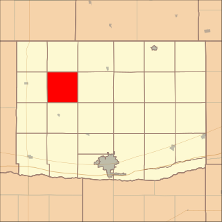
Township 1 is one of five townships in Washington County, Nebraska, United States. The population was 3,464 at the 2000 census. A 2006 estimate placed the township's population at 3,696.
Township 2 is one of five townships in Washington County, Nebraska, United States. The population was 2,338 at the 2000 census. A 2006 estimate placed the township's population at 2,473.
Township 5 is one of five townships in Washington County, Nebraska, United States. The population was 1,388 at the 2000 census. A 2006 estimate placed the township's population at 1,545.
Township 6 is one of five townships in Washington County, Nebraska, United States. The population was 1,516 at the 2000 census. A 2006 estimate placed the township's population at 1,713.
References
- ↑ "Subcounty population estimates: Nebraska 2000-2006". United States Census Bureau, Population Division. 2007-06-28. Archived from the original (CSV) on 2008-02-18. Retrieved 2008-03-04.CS1 maint: discouraged parameter (link)
Municipalities and communities of Washington County, Nebraska, United States | ||
|---|---|---|
| Cities |  | |
| Villages | ||
| Townships | ||
| CDP | ||
| Unincorporated communities | ||
| Former community | ||
| Footnotes | ‡This populated place also has portions in an adjacent county or counties | |
Coordinates: 41°26′14″N96°15′27″W / 41.43722°N 96.25750°W
| | This Washington County, Nebraska state location article is a stub. You can help Wikipedia by expanding it. |