De Soto, Nebraska | |
|---|---|
 Interactive map of De Soto, Nebraska | |
| Coordinates: 41°30′4.15″N96°3′24.15″W / 41.5011528°N 96.0567083°W | |
| Country | United States |
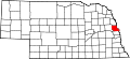
| State | Nebraska |
| County | Washington |
| Elevation | 1,007 ft (307 m) |
| Time zone | UTC-6 (Central (CST)) |
| • Summer (DST) | UTC-5 (CDT) |
| Area code | 402 |
De Soto is an unincorporated community in Washington County, Nebraska, United States. [1] As of today, De Soto contains farmland with about three families residing there. [2]