This article needs additional citations for verification .(April 2021) |
Spiker, Nebraska | |
|---|---|
 Spiker  Spiker | |
| Coordinates: 41°36′26″N96°18′35″W / 41.60722°N 96.30972°W | |
| Country | United States |
| State | Nebraska |
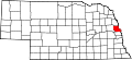
| County | Washington |
| Elevation | 761 ft (232 m) |
| Time zone | UTC-6 (Central (CST)) |
| • Summer (DST) | UTC-5 (CDT) |
Spiker is an unincorporated community in Washington County, Nebraska. [1]