Colfax County is a county in the U.S. state of Nebraska. As of the 2010 United States Census, the population was 10,515. Its county seat is Schuyler. The county and its seat are named after US Vice President (1869-1873) Schuyler Colfax.

Buffalo County is a county located in the U.S. state of Nebraska in the Midwestern United States. As of the 2010 United States Census, the population was 46,102, making it Nebraska's fifth-most populous of the 93 counties. Its county seat is Kearney. The county was created in 1855 and was organized in 1870. It was named after the once-prevalent buffalo herds.

Sidney is a city in and the county seat of Cheyenne County, Nebraska, United States. This city is nine miles north from the Colorado state line. The population was 6,757 at the 2010 census.

Burns is a town in Laramie County, Wyoming, United States. It is part of the Cheyenne, Wyoming Metropolitan Statistical Area. The population was 301 at the 2010 census.
The Territory of Washington was an organized incorporated territory of the United States that existed from March 2, 1853, until November 11, 1889, when the territory was admitted to the Union as the State of Washington. It was created from the portion of the Oregon Territory north of the lower Columbia River and north of the 46th parallel east of the Columbia. At its largest extent, it also included the entirety of modern Idaho and parts of Montana and Wyoming, before attaining its final boundaries in 1863.
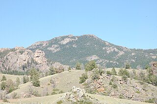
The Laramie Mountains are a range of moderately high peaks on the eastern edge of the Rocky Mountains in the U.S states of Wyoming and Colorado. The range is the northernmost extension of the line of the ranges along the eastern side of the Rockies, and in particular of the higher peaks of the Front Range directly to the south. North of the range, the gap between the Laramie range and the Bighorn Mountains provided the route for historical trails, such as the Oregon Trail, the Mormon Trail, and the Pony Express.

The Dakota, Minnesota and Eastern Railroad was a Class II railroad subsidiary of the Canadian Pacific Railway operating across South Dakota and southern Minnesota in the Northern Plains of the United States. Portions of the railroad also extend into Wyoming, Nebraska, Iowa, and Illinois.

The San Joaquin Valley Railroad is one of several short line railroad companies and is part of the Pacific Region Division of Genesee & Wyoming Inc. It operates about 297 miles (478 km) of track primarily on several lines in California's Central Valley/San Joaquin Valley outside Fresno, California and Bakersfield, California. The SJVR has trackage rights over Union Pacific from Fresno - Goshen Jct - Famoso - Bakersfield - Algoso. The SJVR also operated for the Tulare Valley Railroad (TVRR) from Calwa to Corcoran and Famoso.

Bowman Creek is a tributary of the Susquehanna River in Luzerne County and Wyoming County, in Pennsylvania, in the United States. It is approximately 26 miles (42 km) long and flows through Ross Township and Lake Township in Luzerne County and Noxen Township, Monroe Township, and Eaton Township in Wyoming County. The watershed of the creek has an area of 120 square miles (310 km2). The creek is not designated as an impaired waterbody and its pH is close to neutral, although it has experienced some problems with acid rain. It has low concentrations of dissolved solids like calcium. The creek is relatively small in its upper reaches, but by Noxen, its width is 40 to 60 feet. It is also relatively shallow in many reaches. Rock formations in the watershed include the Catskill Formation, the Huntley Mountain Formation, Burgoon Sandstone, the Mauch Chunk Formation, the Pottsville Group, and the Pocono Formation. Soil associations in the creek's watershed include the Wellsboro-Morris-Oquaga association, the Oquaga-Lackawanna-Arnot association, the Mardin-Bath-Volusia association, and the Wyoming-Pope association.

Cheyenne is the capital and most populous city of Wyoming. It is the principal city of the Cheyenne, Wyoming, Metropolitan Statistical Area, which encompasses all of Laramie County. The population was estimated at 64,235 as of 2019. It is the northern terminus of the extensive Southern Rocky Mountain Front, which extends southward to Albuquerque, New Mexico, and includes the fast-growing Front Range Urban Corridor. Cheyenne is situated on Crow Creek and Dry Creek. The Cheyenne metropolitan area had a 2010 population of 91,738, making it the 354th-most populous metropolitan area in the United States.

There is evidence of prehistoric human habitation in the region known today as the U.S. state of Wyoming stretching back roughly 13,000 years. Stone projectile points associated with the Clovis, Folsom and Plano cultures have been discovered throughout Wyoming. Evidence from what is now Yellowstone National Park indicates the presence of vast continental trading networks since around 1000 years ago. The Union Pacific Railroad played a central role in the European settlement of the area. Wyoming became a U.S. territory in 1868 and became the 44th U.S. state in 1890. It was the first state to grant women the right to vote, in 1869.

Ames is an unincorporated community and census-designated place in southern Dodge County, Nebraska, United States. As of the 2010 census it had a population of 24.

Union Hill is a former settlement in Nevada County, California, 1.5 mi (2.4 km) from Grass Valley. Its elevation is 2,700 ft (820 m) above sea level.
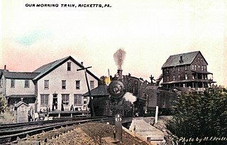
Ricketts is a ghost town that was established as a lumber mill company town in Sullivan and Wyoming counties, in the U.S. state of Pennsylvania. Ricketts was built in 1890 along Mehoopany Creek in both Colley Township in Sullivan County and Forkston Township in Wyoming County for sawmills of the Trexler and Turrell Lumber Company. It was named for Robert Bruce Ricketts, who owned most of the land and timber around the village, and who was a partner in the company with Harry Clay Trexler, J.H. Turrell, and others. Ricketts had 800 inhabitants at its peak and extended into the northernmost section of what is now Ricketts Glen State Park. Rail lines were built to the mills at Ricketts, including the Bowman Creek branch of the Lehigh Valley Railroad which opened in 1893. The mills closed in 1913 when the lumber was exhausted and the last house was torn down in the 1930s.

Rapid City, Pierre and Eastern Railroad is a Class II railroad operating across South Dakota and southern Minnesota in the northern plains of the United States. Portions of the railroad also extend into Wyoming, and Nebraska. It is owned and operated by Genesee & Wyoming.
Colton is a village in Cheyenne County, Nebraska, United States.
Brownson is an unincorporated community in Cheyenne County, Nebraska, United States.
Barton is an unincorporated community in Deuel County, Nebraska, United States. It is located west of Big Springs, along the South Platte River, half way to the Colorado border.

Cooper Lake is a railroad station and former settlement in Albany County, Wyoming, United States.
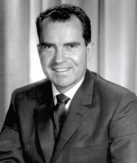
The 1960 United States presidential election in Wyoming took place on November 8, 1960, as part of the 1960 United States presidential election. State voters chose three representatives, or electors, to the Electoral College, who voted for president and vice president.