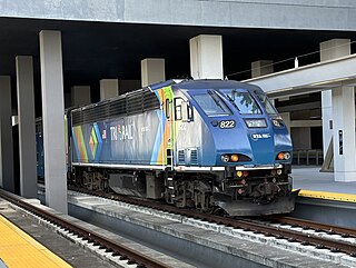
Tri-Rail is a commuter rail service linking Miami, Fort Lauderdale and West Palm Beach in Florida, United States. The Tri prefix in the name refers to the three counties served by the railroad: Palm Beach, Broward, and Miami-Dade. Tri-Rail is managed by the South Florida Regional Transportation Authority (SFRTA) along CSX Transportation's former Miami Subdivision; the line is now wholly owned by the Florida DOT. The 80.0-mile-long (128.7 km) system has 19 stations along the Southeast Florida coast, and connects directly to Amtrak at numerous stations, to Metrorail at the Metrorail Transfer station, Miami Airport station, and MiamiCentral, and to Brightline at MiamiCentral.

The Silver Star is a long-distance passenger train operated by Amtrak on a 1,522-mile (2,449 km) route between New York City and Miami via Washington, D.C., Richmond, Virginia, Raleigh, North Carolina, Columbia, South Carolina, Savannah, Georgia, Jacksonville, Florida, and Tampa, Florida. The Silver Star and its sister train in the Silver Service brand, the Silver Meteor, are the descendants of numerous long-distance trains that operated between Florida and New York for most of the 20th century.

The Southeast Corridor (SEC) is a proposed passenger rail transportation project in the Mid-Atlantic and Southeastern United States to extend high-speed passenger rail services from the current southern terminus of the Northeast Corridor in Washington, D.C.. Routes would extend south via Richmond and Petersburg, Virginia, with a spur to Norfolk in Virginia's Hampton Roads region; the mainline would continue south to Raleigh, Durham, Greensboro, and Charlotte, North Carolina. Since the corridor was first established in 1992, the U.S. Department of Transportation (USDOT) has extended it further to Atlanta, Georgia and Macon, Georgia; Greenville, South Carolina; Columbia, South Carolina; Jacksonville, Florida; and Birmingham, Alabama.
The Charlotte Area Transit System (CATS) is the agency responsible for public transportation in the Charlotte metropolitan area. CATS operates bus and rail transit services in Mecklenburg County and surrounding areas. Established in 1999, CATS' bus and rail operations carry about 320,000 riders on an average week. CATS is governed by the Metropolitan Transit Commission and is operated as a department of the City of Charlotte. In 2023, the system had a ridership of 13,476,600, or about 40,900 per weekday as of the first quarter of 2024.

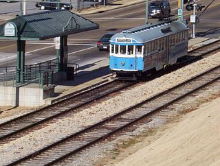
The Charlotte Trolley was a heritage streetcar that operated in Charlotte in the U.S. state of North Carolina. The line ran along the former Norfolk Southern right of way between Tremont Avenue in the Historic South End in a northerly direction to its terminus at 9th Street Uptown. It ran on tracks mostly shared with the Lynx Blue Line.

Transportation in the Commonwealth of Virginia is by land, sea and air. Virginia's extensive network of highways and railroads were developed and built over a period almost 400 years, beginning almost immediately after the founding of Jamestown in 1607, and often incorporating old established trails of the Native Americans.
North Carolina Highway 160 is a primary state highway in the U.S. state of North Carolina. The highway runs north–south, connecting the Steele Creek neighborhood of Charlotte, Charlotte Douglas International Airport, and Uptown Charlotte.

Miami Intermodal Center (MIC) is an intermodal rapid transit, commuter rail, intercity rail, local bus, and intercity bus transportation hub in Miami-Dade County, Florida, just outside the Miami city limits near the Grapeland Heights neighborhood. The facility was constructed by the Florida Department of Transportation and is owned by the Greater Miami Expressway Agency.

Charlotte station is an Amtrak station located at 1914 North Tryon Street, about 1.5 miles (2.4 km) to the northeast of Uptown Charlotte. Owned by Norfolk Southern, it is located near that railroad's yard outside Uptown.

J. Douglas Galyon Depot, also known as Greensboro station, is an intermodal transit facility in Greensboro, North Carolina. Located at 236 East Washington Street in downtown Greensboro, it serves Amtrak passenger rail and is the city's main hub for local and intercity buses.

The Charlotte Transportation Center (CTC), also known as Arena or CTC/Arena, is an intermodal transit station in Center City Charlotte, North Carolina, United States. It serves as the central hub for the Charlotte Area Transit System (CATS) buses and connects with the LYNX Blue Line and CityLYNX Gold Line. It is located on East Trade Street, Fourth Street and Brevard Street. Notable places nearby include the Bank of America Corporate Center, Belk Theater, EpiCentre, Overstreet Mall and the Spectrum Center.

I-485/South Boulevard is a light rail station in Charlotte, North Carolina. The elevated island platform is the southern terminus stop along the Lynx Blue Line and includes the second largest park and ride operated by Charlotte Area Transit System (CATS). Serving both Carolina Pavilion and Sterling neighborhood in the immediate area, it also serves commuters from Pineville, Ballantyne, and the South Carolina border towns.
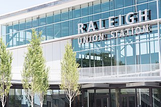
Raleigh Union Station is an intermodal transit station in Raleigh, North Carolina, United States. Train service began the morning of July 10, 2018. Its main building serves as an Amtrak train station, while a future adjacent building will serve as the bus terminus for GoTriangle. The station is located at the Boylan Wye, a railroad junction used by CSX and Norfolk Southern, and adjacent to the Depot Historic District in downtown Raleigh.
The Lynx Red Line is a proposed commuter rail service, connecting the towns in northern Mecklenburg and southern Iredell counties to Uptown Charlotte, North Carolina. In 2019, after a reevaluation of the entire corridor, the Charlotte Area Transit System (CATS) decided to move forward with BRT and shelve the commuter rail; which had been met with frustration by various city leaders and residents impacted by it.
The Lynx Silver Line is a proposed east–west light rail line in Charlotte, North Carolina. The Silver Line would connect the outlying cities and towns of Belmont, Matthews, Stallings and Indian Trail to Uptown Charlotte and the Charlotte Douglas International Airport. In the refined locally preferred alternative (LPA), released in early 2021, the route is estimated to be around 29 miles (47 km), with 29 stations and one maintenance facility.
Memphis, Tennessee has developed into a major Mid-American commercial and transportation hub because of its location on the Mississippi River and a convergence of numerous rail and highway links. Four rail and highway bridges cross the Mississippi River at Memphis. In addition, Memphis International Airport has become the world's largest airfreight terminal.

Charlotte Gateway Station is a future intermodal transit station in Charlotte, North Carolina, United States. Currently operating as a streetcar stop for the CityLynx Gold Line, with an adjoining bus station for Greyhound Lines intercity buses, it is the centerpiece of the overall 19-acre (7.7 ha) Station District, and it will serve Charlotte Area Transit System (CATS) bus lines, the Lynx Silver Line light rail, and Amtrak intercity trains. The district will also include parking facilities, mixed-use development and an elevated greenway. Estimated at a cost of $800.1 million for full implementation of all public and private components, the project will be built in three phases, with Amtrak service tentatively scheduled to start in 2026–2027.

SunRail is a commuter rail system in the Greater Orlando, Florida, area. Services began on May 1, 2014. The system comprises 16 stations along a former CSX Transportation line connecting Volusia County and Osceola County through Downtown Orlando. The SunRail system is financed by the state and federal governments and the counties it serves. SunRail is Florida's second commuter rail system after South Florida's Tri-Rail.

The Carolinian is a daily Amtrak passenger train that runs between New York City and Charlotte, North Carolina, with major stops in Philadelphia, Baltimore, Washington, Richmond, Raleigh, Cary, Durham, and Greensboro. The 704-mile (1,133 km) service is the longest state-supported route in the Amtrak system. Northbound trains leave Charlotte at breakfast time and arrive in New York in the early evening, while southbound trains leave New York during the morning rush and arrive in Charlotte in the evening.

The Lynx Blue Line is a light rail line in Charlotte, North Carolina, United States. Opened in 2007, it was the first rail line of the Charlotte Area Transit System, and the first major rapid rail service of any kind in the state. The 26-station, 19.3-mile (31.1 km) line extends from its northern terminus at the University of North Carolina at Charlotte in University City through NoDa, Uptown, and South End, then runs along South Boulevard to its southern terminus just north of Interstate 485 at the Pineville city limits. The line carries an average of over 27,700 passenger trips every day and offers connections to the CATS' CityLynx Gold Line which opened in 2015.

