
Fort Dearborn was a United States fort, first built in 1803 beside the Chicago River, in what is now Chicago, Illinois. It was constructed by U.S. troops under Captain John Whistler and named in honor of Henry Dearborn, then United States Secretary of War. The original fort was destroyed following the Battle of Fort Dearborn during the War of 1812, and a replacement Fort Dearborn was constructed on the same site in 1816 and decommissioned by 1837.

The Illinois Country, also referred to as Upper Louisiana, was a vast region of New France claimed in the 1600s that later fell under Spanish and British control before becoming what is now part of the Midwestern United States. While the area claimed included the entire Upper Mississippi River watershed, French colonial settlement was concentrated along the Mississippi and Illinois Rivers in what is now the U.S. states of Illinois and Missouri, with outposts on the Wabash River in Indiana. Explored in 1673 from Green Bay to the Arkansas River by the Canadien expedition of Louis Jolliet and Jacques Marquette, the area was claimed by France. It was settled primarily from the Pays d'en Haut in the context of the fur trade, and in the establishment of missions from Canada by French Catholic religious orders. Over time, the fur trade took some French to the far reaches of the Rocky Mountains, especially along the branches of the broad Missouri River valley. The "Illinois" in the territory's name is a reference to the Illinois Confederation, a group of related Algonquian native peoples.

The Honey War was a bloodless territorial dispute in 1839 between Iowa Territory and Missouri over their border.

The Black Hawk Purchase, also known as the Forty-Mile Strip or Scott's Purchase, extended along the West side of the Mississippi River from the north boundary of Missouri North to the Upper Iowa River in the northeast corner of Iowa. It was fifty miles wide at the ends, and forty in the middle, and is sometimes called the "Forty-Mile Strip". The land, originally owned by the Sauk, Meskwaki (Fox), and Ho-Chunk (Winnebago) Native American people, was acquired by treaty following their defeat by the United States in the Black Hawk War. After being defeated the Sauk and Meskwaki were forced to relinquish another 2.5 million hectares or and give up their rights to plant, hunt, or fish on the land. The purchase was made for $640,000 on September 21, 1832 and was named for the chief Black Hawk, who was held prisoner at the time the purchase was completed. The Black Hawk Purchase contained an area of 6 million acres (24,000 km²), and the price was equivalent to 11 cents/acre. The region is bounded on the East by the Mississippi River and includes Dubuque, Fort Madison, and present-day Davenport.

Fort Armstrong (1816–1836), was one of a chain of western frontier defenses which the United States erected after the War of 1812. It was located at the foot of Rock Island, in the Mississippi River near the present-day Quad Cities of Illinois and Iowa. It was five miles from the principal Sauk and Meskwaki village on the Rock River in Illinois. Of stone and timber construction, 300 feet square, the fort was begun in May 1816 and completed the following year and consisted of three large blockhouses, like the replica, on its prominent corners. In 1832, the U.S. Army used the fort as a military headquarters during the Black Hawk War. It was normally garrisoned by two companies of United States Army regulars. With the pacification of the Indian threat in Illinois, the U.S. Government ceased operations at Fort Armstrong and the U.S. Army abandoned the frontier fort in 1836.
John C. Sullivan was a surveyor who established the Indian Boundary Line and the Sullivan Line which were to form the boundary between Native Americans and white settlers in Indian Territory from Iowa to Texas.

The Treaty of Fort Clark was signed at Fort Osage on November 10, 1808, in which the Osage Nation ceded all the land east of the fort in Missouri and Arkansas north of the Arkansas River to the United States. The Fort Clark treaty and the Treaty of St. Louis in which the Sac and Fox ceded northeastern Missouri along with northern Illinois and southern Wisconsin were the first two major treaties in the newly acquired Louisiana Purchase. The affected tribes, upset with the terms, were to side with the British in the War of 1812. Following the settlement of that war, John C. Sullivan for the United States was to survey the ceded land in 1816 (adjusting it 23 miles westward to the mouth of the Kansas River to create the Indian Boundary Line west of which and south of which virtually all tribes were to be removed in the Indian Removal Act in 1830.

The Potawatomi Trail of Death was the forced removal by militia in 1838 of about 859 members of the Potawatomi nation from Indiana to reservation lands in what is now eastern Kansas.
The Sullivan Line originally marked in 1816 forms three quarters of the border between Missouri and Iowa and an extension of it forms the remainder. The line was initially created to establish the limits of Native American territory ; disputes over the boundary were to erupt into the Honey War.
A Half-Breed Tract was a segment of land designated in the western states by the United States government in the 19th century specifically for Métis of American Indian and European or European-American ancestry, at the time commonly known as half-breeds. The government set aside such tracts in several parts of the Midwestern prairie region, including in Iowa Territory, Nebraska Territory, Kansas Territory, Minnesota Territory, and Wisconsin Territory.

Wabasha II, also known as Wapahasha, Wapasha, or "The Leaf," succeeded his father as head chief of the Mdewakanton Dakota tribe in the early 1800s. He led the Dakota forces fighting with the British in the War of 1812, but sided with the United States in the Black Hawk War of 1832. Chief Wabasha II signed the Treaties of Prairie du Chien in 1825 and 1830.
Wabasha III (Wapahaśa) was a prominent Dakota Sioux chief, also known as Joseph Wabasha. He succeeded his father as head chief of the Mdewakanton Dakota in 1836. Following the Dakota War of 1862 and the forced removal of the Dakota to Crow Creek Reservation, Wabasha became known as head chief of the Santee Sioux. In the final years of his life, Chief Wabasha helped his people rebuild their lives at the Santee Reservation in Nebraska.

The Treaty of Prairie du Chien may refer to any of several treaties made and signed in Prairie du Chien, Wisconsin between the United States, representatives from the Sioux, Sac and Fox, Menominee, Iowa, Ho-Chunk and the Anishinaabeg Native American peoples.

The Treaty of Prairie du Chien may refer to any of several treaties made and signed in Prairie du Chien, Wisconsin between the United States, representatives from the Sioux, Sac and Fox, Menominee, Ioway, Winnebago and the Anishinaabeg Native American peoples.
The Treaty of Prairie du Chien may refer to any of several treaties made and signed in Prairie du Chien, Wisconsin between the United States, representatives from the Sioux, Sac and Fox, Menominee, Ioway, Winnebago and the Anishinaabeg Native American peoples.
The fourth Treaty of Prairie du Chien was negotiated between the United States and the Sac and Meskwaki, the Mdewakanton, Wahpekute and Sisseton Sioux, Omaha, Ioway, Otoe and Missouria peoples. The treaty was signed on July 15, 1830, with William Clark and Willoughby Morgan representing the United States. Through additional negotiations conducted in St. Louis on October 13, 1830, Yankton Sioux and Santee Sioux agreed to abide by the 1830 Treaty of Prairie du Chien. The US government announced the treaty and its numerous adherents on February 24, 1831.

The Treaty of St. Louis of 1804 was a treaty concluded by William Henry Harrison on behalf of the United States of America and five Sauk and Meskwaki chiefs led by Quashquame.
The Treaty of St. Louis is the name of a series of treaties signed between the United States and various Native American tribes from 1804 through 1824. The fourteen treaties were all signed in the St. Louis, Missouri area.

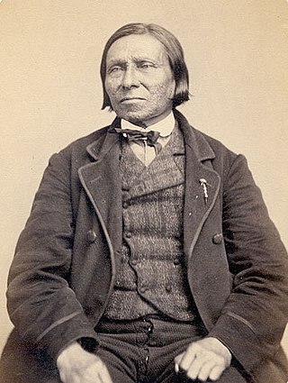
Alexander Robinson, was a British-Ottawa chief born on Mackinac Island who became a fur trader and ultimately settled near what later became Chicago. Multilingual in Odawa, Potawatomi, Ojibwa, English and French, Robinson also helped evacuate survivors of the Fort Dearborn Massacre in 1812. In 1816, Robinson was a translator for native peoples during the Treaty of St. Louis. He became a Potawatomi chief in 1829 and in that year and in 1833, he and fellow Metis Billy Caldwell negotiated treaties on behalf of the United Nations of Ottawa, Chippewa, and Potawatomi with the United States. Although Robinson helped lead Native Americans across the Mississippi River in 1835, unlike Caldwell, Robinson returned to the Chicago area by 1840 and lived as a respected citizen in western Cook County until his death decades later.