U.S. Route 92 or U.S. Highway 92 is a 181-mile (291 km.) U.S. Route entirely in the U.S. state of Florida. The western terminus is at US 19 Alt. and SR 687 in downtown St. Petersburg. The eastern terminus is at SR A1A in Daytona Beach.
Interstate 294 (I-294) is a tolled auxiliary Interstate Highway in the northeastern part of the U.S. state of Illinois. Forming the southern portion of the Tri-State Tollway in Illinois, I-294 runs from South Holland at I-80/I-94 and Illinois Route 394 (IL 394) to Northbrook at I-94. I-294 is 53.42 miles (85.97 km) long; 5.32 miles (8.56 km) are shared with I-80. It serves as a bypass around the city of Chicago. I-294 is also the longest auxiliary route of I-94, at 10 miles (16 km) longer than I-494 in Minneapolis–Saint Paul. In addition, the tollway is the longest auxiliary Interstate Highway in Illinois, and it intersects the most primary Interstate Highways at six.
State Route 2 (SR 2) is a state highway in the U.S. state of California. It connects the Los Angeles Basin with the San Gabriel Mountains and the Victor Valley in the Mojave Desert. The highway's southwestern end is at the intersection of Centinela Avenue at the Santa Monica-Los Angeles border and its northeastern end is at SR 138 east of Wrightwood. The SR 2 is divided into four segments, and it briefly runs concurrently with U.S. Route 101 (US 101) and Interstate 210 (I-210). The southwestern section of SR 2 runs along a segment of the east–west Santa Monica Boulevard, an old routing of US 66, to US 101 in East Hollywood; the second section runs along segments of both the north–south Alvarado Street and Glendale Boulevard in Echo Park; the third section to I-210 in Glendale is known as the north–south Glendale Freeway; and the northeastern portion from I-210 in La Cañada Flintridge to SR 138 is designated as the Angeles Crest Highway.

Illinois Route 64 is an east–west state highway in Northern Illinois. Its western terminus is at the Iowa state line, connecting with U.S. Route 52 (US 52) and Iowa Highway 64 via the Dale Gardner Veterans Memorial Bridge at the Mississippi River west of Savanna. IL 64 then travels east through Mount Carroll, Lanark, Mount Morris, Oregon, Sycamore, Lily Lake, Saint Charles and the western suburbs of Chicago before terminating at U.S. Route 41 on the city's north side. IL 64 is 138.61 miles (223.07 km) long.

Halsted Street is a major north-south street in the U.S. city of Chicago, Illinois.
Foothill Boulevard is a major road in the city and county of Los Angeles, as well as an arterial road in the city and county of San Bernardino, stretching well over 60 miles (97 km) in length, with some notable breaks along the route. Like its name implies, Foothill Boulevard runs across the foothills of the San Gabriel and San Bernardino Mountains.
U.S. Route 12 (US 12) in the U.S. state of Illinois is an arterial highway that runs northwest to southeast through the Chicago metropolitan area. It enters Illinois at the Wisconsin border north of Richmond, and exits into Hammond, Indiana, from Chicago near the foot of the onramp to the Indiana Toll Road ; as it exits Illinois, the route is also concurrent with US 20 and US 41. Within Illinois, US 12 runs for a distance of 85.14 miles (137.02 km).

Interstate 55 (I-55) is a major north–south Interstate Highway in the US state of Illinois that connects St. Louis, Missouri, to the Chicago metropolitan area. It enters the state from Missouri near East St. Louis, Illinois, and runs to U.S. Route 41 near Downtown Chicago, where the highway ends, a distance of 294.38 miles (473.76 km). The road also runs through the Illinois cities of Springfield, Bloomington, and Joliet. The section in Cook County is officially named the Stevenson Expressway, and in DuPage County its officially named the Joliet Freeway or the Will Rogers Freeway. The section from the south suburbs of Chicago to the area near Pontiac is officially named the Barack Obama Presidential Expressway after the 44th President, Barack Obama, who launched his political career from Illinois.
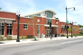
95th Street is a major east–west highway on Chicago's South Side and in the southwest suburbs, designated as 9500 South in Chicago's address system. 95th Street is 11 miles (18 km) south of Madison Street.
Cicero Avenue, also known as Skokie Boulevard in Skokie and Wilmette, is a major north–south street in Chicago and its suburbs in Cook and Will Counties. It carries Illinois Route 50 from its south end to Skokie, and U.S. Route 41 from Skokie to its north end. It runs north from the Governors Highway in University Park, next to Governors State University, crossing major highways such as Interstate 294, Interstate 55, Interstate 290 and Interstate 94, to Interstate 94 in Wilmette. Cicero Avenue is located 6 miles west of State Street.
Many arterial roads in the Phoenix metropolitan area have the same name in multiple cities or towns. Some roads change names or route numbers across town borders, resulting in occasional confusion. For example, the road known as Apache Boulevard in Tempe continues east as Main Street in neighboring Mesa and then as Apache Trail in Apache Junction. Although Broadway Road maintains the same name through Goodyear, Avondale, Phoenix, Tempe, Mesa, and Apache Junction, each town uses a different reference point for address numbers.

Interstate 90 Business may refer to several business routes of the Interstate Highway System that connects Interstate 90 with the central business district of various cities bypassed by I-90. Each business route can be either a business loop or a business spur, depending on whether both ends connect to I-90. The business route in each community is considered a unique route. In many cases, these routes are a former section of a U.S. Route.

Several special routes of U.S. Route 20 exist. In order from west to east they are as follows.

Ohio Street is a major east–west one-way street in downtown Chicago. From west to east, it runs from an interchange with Interstate 90 (I-90) and I-94, also known as the Kennedy Expressway, to U.S. Route 41 (US 41), also known as Lake Shore Drive, just west of Lake Michigan.
159th Street is a major east-west street in the southern suburbs of Chicago. It runs east from Thornton Street in Lockport, crossing Interstate 355 in Lockport, Interstate 57 in Markham, Interstate 294 in Harvey and Interstate 94 in South Holland, on its way to its east end at U.S. Route 6 and Illinois Route 83 in Calumet City. The road carries no routes from Hopkins Road to Broadway, Independence Boulevard, Illinois Route 7 from Thornton Street to Wolf Road, and carries U.S. Route 6 from Wolf Road to Torrence Avenue, and no routes again from Torrence Avenue to Cline Avenue. The Street intersects 4 Interstate Highways. Interstate 355, Interstate 57, Interstate 294, and Interstate 94.

Pershing Road is an east-west street on the south side of Chicago and in its immediate western suburbs in Cook County, Illinois. It is precisely four miles south of Madison Street, the division point between north and south street numbering, and marks the 3900 South point in the region's street numbering system. Its western segment, more commonly referred to as 39th Street, runs east from a U.S. Route 34 in Lyons to Illinois Route 50 in Cicero. Its eastern segment, officially known as Pershing Road, runs east from a cul-de-sac at 3600 West to Oakwood Boulevard, which continues east ending at U.S. Route 41. All of the eastern segment lies within the city of Chicago.
Garfield Boulevard is an east-west street on the south side of Chicago and its immediate western suburbs. Its western segment, entirely known as 55th Street, runs east from Maple Avenue in Downers Grove until it becomes Joliet Road in Countryside. Its eastern segment, known only as Garfield Boulevard from Western Avenue in Gage Park to Elsworth Drive in Washington Park, runs east from Archer Avenue and Narragansett Avenue to South Shore Drive, just west of U.S. Route 41. All of the eastern segment of 55th Street lies within the city limits of Chicago.
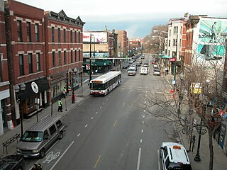
Armitage Avenue is an east-west street in Chicago and its western suburbs, being located at 2000 North in the Chicago address system, two and one-half miles north of Madison Street. Its west end is located at President Street in the western suburb of Glendale Heights. In the western suburbs, it is a minor road, being split into many segments, usually by freeways. Armitage Avenue becomes a major street at its intersection with Grand Avenue in Chicago, continuing east until Mendell Street, just east of its interchange with Interstates 90 and 94, and just west of the North Branch of the Chicago River. Immediately east of the river, it resumes as a minor road, beginning at a cul-de-sac, heading east until Southport Avenue. At Racine Avenue, Armitage Avenue is once again a major street. From here, it continues east until its east end at Clark Street, just west of Lincoln Park.

Fullerton Avenue, known as Fullerton Parkway from its intersection with Halsted Street and Lincoln Avenue to its east end, is a major east–west street in Chicago and its western suburbs. Its west end is at Gary Avenue in Carol Stream. The road is split in many locations, usually because of freeways or railroads. Its east end is located at U.S. Route 41 in Chicago.

Dempster Street is a major east–west street in the northern suburbs of Chicago. It is assigned 8800 North in the Chicago address system, being located 11 miles (18 km) north of Madison Street.


