Downtown Chicago, Illinois, has some double-decked and a few triple-decked streets immediately north and south of the Main Branch and immediately east of the South Branch of the Chicago River. The most famous and longest of these is Wacker Drive, which replaced the South Water Street Market upon its 1926 completion.[1] The resulting bi-level street has an upper-level riverfront boulevard, a lower-level roadway for commercial and through traffic, and a recreational walkway at water level.[2]
The multilevel configuration arose from geography and traffic patterns in the Loop. In most other parts of the rest of the city near the Chicago River, only major streets crossed the river. However, most downtown streets crossed the river, and all of these crossings were bascule bridges, which required height clearances at the approaches to and over the river. Clearances were further necessitated due to the presence of many existing railroad tracks along the river (as in the west bank of the south branch) and tracks that ended at the river (such as the tracks ending at Randolph Street).[3] Thus, a clearance zone was created along the river at locations that contained many closely spaced crossings. Many double-decked or triple-decked streets were created because they fell within this clearance zone.
This also created an anomaly not only in the layout and uses of streets, but also planning of buildings. Generally, the upper levels of the multi-level streets usually serve local traffic. The primary entrances of buildings are usually located on this level. The lower levels generally serve through-traffic and trucks serving businesses along the roads. This level houses the receiving/shipping entrances to the buildings on these streets. As a result, loading docks at street level are noticeably absent.
The first raising occurred from 1855 to 1858, when streets and buildings were raised between four and seven feet above their former elevation, just a few feet above lake level, where they were constantly muddy. The higher elevation allowed for sewers and proper drainage.[4] However, this did not produce any two-level streets; the first of those was Michigan Avenue in the late 1910s. When the Illinois Center development was built on the east side of downtown, a new upper level was built, making most streets in that area three levels.
The double-decked portion of Wabash Avenue north of the Chicago River was built in 1930, in conjunction with the single-level Wabash Avenue Bridge. On January 3, 2005, the upper and lower levels were closed at Kinzie Street for reconstruction (in conjunction with the Trump Tower Chicago development) but have since been reopened.
The Chicago River is a system of rivers and canals with a combined length of 156 miles (251 km) that runs through the city of Chicago, including its center. Though not especially long, the river is notable because it is one of the reasons for Chicago's geographic importance: the related Chicago Portage is a link between the Great Lakes and the Mississippi River Basin, and ultimately the Gulf of Mexico.
The Loop, one of Chicago's 77 designated community areas, is the central business district of the city and is the main section of Downtown Chicago. Home to Chicago's commercial core, it is the second largest commercial business district in North America after Midtown Manhattan in New York City, and contains the headquarters and regional offices of several global and national businesses, retail establishments, restaurants, hotels, and theaters, as well as many of Chicago's most famous attractions. It is home to Chicago's City Hall, the seat of Cook County, and numerous offices of other levels of government and consulates of foreign nations. The intersection of State Street and Madison Street is the origin point for the address system on Chicago's street grid. Most of Grant Park's 319 acres are in the eastern section of the community area. The Loop community area is bounded on the north and west by the Chicago River, on the east by Lake Michigan, and on the south by Roosevelt Road.
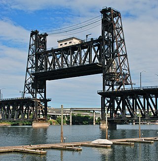
The Steel Bridge is a through truss, double-deck vertical-lift bridge across the Willamette River in Portland, Oregon, United States, opened in 1912. Its lower deck carries railroad and bicycle/pedestrian traffic, while the upper deck carries road traffic, and light rail (MAX), making the bridge one of the most multimodal in the world. It is the only double-deck bridge with independent lifts in the world and the second oldest vertical-lift bridge in North America, after the nearby Hawthorne Bridge. The bridge links the Rose Quarter and Lloyd District in the east to Old Town Chinatown neighborhood in the west.
Michigan Avenue is a north-south street in Chicago that runs at 100 east on the Chicago grid. The northern end of the street is at DuSable Lake Shore Drive on the shore of Lake Michigan in the Gold Coast Historic District. The street's southern terminus is at Sibley Boulevard in the southern suburb of Dolton, but like many other Chicago streets, it exists in several disjointed segments.
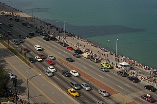
Lake Shore Drive is an expressway that runs alongside the shoreline of Lake Michigan, and adjacent to parkland and beaches, in Chicago, Illinois. Except for the portion north of Foster Avenue, the Drive is designated as part of U.S. Highway 41. A portion of the highway on the Outer Drive Bridge and its bridge approaches is multilevel.
Wacker Drive is a major multilevel street in Chicago, Illinois, running along the south side of the main branch and the east side of the south branch of the Chicago River in the Loop. The vast majority of the street is double-decked; the upper level intended for local traffic, and the lower level for through-traffic and trucks serving buildings on the road. It is sometimes cited as a precursor to the freeway, though when it was built the idea was that pleasure vehicles would use the upper level. It is the only street in the city that is prefixed with all four cardinal directions, albeit on different parts of its route. The drive is named for early 20th century Chicago businessman and city planner Charles H. Wacker.
The Magnificent Mile, sometimes referred to as The Mag Mile, is an upscale section of Chicago's Michigan Avenue, running from the Chicago River to Oak Street in the Near North Side. The district is located within downtown and one block east of Rush Street. The Magnificent Mile serves as the main thoroughfare between Chicago's Loop business district and its Gold Coast. It is generally the western boundary of the Streeterville neighborhood, to its east, and of River North to the west.
Illinois Center is a mixed-use urban development in downtown Chicago, Illinois, USA, lying east of Michigan Avenue. It is notable in that the streets running through it have three levels. Elsewhere in Chicago, some streets have two levels, with the lower level for through traffic and service vehicles and the upper level for other local traffic. In Illinois Center, the lower level has been split, with a middle level for through traffic and a lower level for service vehicles.
The Chicago Pedway is a network of tunnels, ground-level concourses and bridges in Chicago, Illinois connecting skyscrapers, retail stores, hotels, and train stations throughout the central business district.
Randolph Street is a street in Chicago. It runs east–west through the Chicago Loop, carrying westbound traffic west from Michigan Avenue across the Chicago River on the Randolph Street Bridge, interchanging with the Kennedy Expressway (I-90/I-94), and continuing west. It serves as the northern boundary of Grant Park and the Chicago Landmark Historic Michigan Boulevard District. Several large theaters, as well as city and state government buildings are on and adjacent to Randolph. Metra's Millennium Station is located under Randolph Street.
Columbus Drive is a north–south street in Chicago, Illinois, which bisects Grant Park. It is 300 East in Chicago's street numbering system. Its south end is an interchange with Lake Shore Drive at Soldier Field. After intersecting Illinois Street, it becomes Fairbanks Court and continues to the north, terminating at Chicago Avenue.
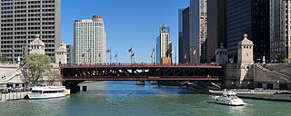
The DuSable Bridge is a bascule bridge that carries Michigan Avenue across the main stem of the Chicago River in downtown Chicago, Illinois, United States. The bridge was proposed in the early 20th century as part of a plan to link Grant Park (downtown) and Lincoln Park (uptown) with a grand boulevard. Construction of the bridge started in 1918, it opened to traffic in 1920, and decorative work was completed in 1928. The bridge provides passage for vehicles and pedestrians on two levels. An example of a fixed trunnion bascule bridge, it may be raised to allow tall ships and boats to pass underneath. The bridge is included in the Michigan–Wacker Historic District and has been designated as a Chicago Landmark.
The Historic Michigan Boulevard District is a historic district in the Loop community area of Chicago in Cook County, Illinois, United States encompassing Michigan Avenue between 11th or Roosevelt Road, depending on the source, and Randolph Streets and named after the nearby Lake Michigan. It was designated a Chicago Landmark on February 27, 2002. The district includes numerous significant buildings on Michigan Avenue facing Grant Park. This section of Michigan Avenue includes the eastern terminus of U.S. Route 66. The district is one of the world's best known one-sided streets rivalling Fifth Avenue in New York City and Edinburgh's Princes Street. It lies immediately south of the Michigan–Wacker Historic District and east of the Loop Retail Historic District.
Rush Street is a one-way street in the Near North Side community area of Chicago in Cook County, Illinois, United States. The street, which starts at the Chicago River between Wabash and North Michigan Avenues, runs directly north until it slants on a diagonal as it crosses Chicago Avenue then it continues to Cedar and State Streets, making it slightly less than a mile long. One lane also runs southbound from Ohio Street (600N) to Kinzie Street (400N) as part of a two-way street segment. It runs parallel to and one block west of the Magnificent Mile on the two-way traffic North Michigan Avenue, which runs at 100 east up to 950 north. The street, which is also one block east of the one-way southbound Wabash Avenue, formerly ran slightly further south to the Chicago River where over time various bridges connected it to the Loop, Chicago's central business district.
The Michigan–Wacker Historic District is a National Register of Historic Places District that includes parts of the Chicago Loop and Near North Side community areas in Chicago, Illinois, United States. The district is known for the Chicago River, two bridges that cross it, and eleven high rise and skyscraper buildings erected in the 1920s. Among the contributing properties are the following Chicago Landmark structures:
The Chicago Lakefront Trail (LFT) is a 18.5-mile-long (29.8 km) partial shared-use path for walking, jogging, skateboarding, and cycling, located along the western shore of Lake Michigan in Chicago, Illinois. The trail passes through and connects Chicago's four major lakefront parks along with various beaches and recreational amenities. It also serves as a route for bicycle, skateboard and personal transporter commuters. On busy summer days 70,000 people use the trail.
Ida B. Wells Drive is a major east–west street in downtown Chicago, Illinois, in the United States. It runs east from the Jane Byrne Interchange, where it meets Interstate 90 (I-90), I-94 and I-290. At Wells Street, Ida B. Wells Drive continues as a surface street past State Street and Michigan Avenue, until ending at Columbus Drive in Grant Park in front of the Buckingham Fountain. In 2018, the editorial board of The New York Times praised the Chicago City Council's renaming of the street to honor the journalist and civil rights activist Ida B. Wells.
The Chicago Riverwalk is a multi-use public open space located on the south bank of the main branch of the Chicago River in Chicago, extending from Lake Michigan and the Outer Drive Bridge westward to Lake Street. The Chicago Riverwalk contains restaurants, bars, cafes, small parks, boat and kayak rentals, a Vietnam War memorial, and other amenities.
This page is based on this Wikipedia article Text is available under the CC BY-SA 4.0 license; additional terms may apply. Images, videos and audio are available under their respective licenses.