
Des Plaines is a city in Cook County, Illinois, United States. Per the 2020 census, the population was 60,675. The city is a suburb of Chicago and is located just north of O'Hare International Airport. It is situated on and is named after the Des Plaines River, which runs through the city just east of its downtown area.

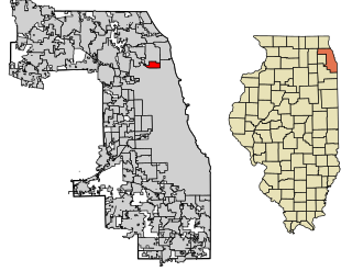
Elk Grove Village is a village in Cook and DuPage counties in the U.S. state of Illinois. Per the 2020 census, the population was 32,812. Located 20 miles (32 km) northwest of Chicago along the Golden Corridor, the Village of Elk Grove Village was incorporated on July 17, 1956. It is directly adjacent to O'Hare International Airport and is economically important to the Chicago metropolitan area due to its large industrial park, located on the eastern border of the village. The community is served by several Interstate highways including I-90, I-290/I-355/Route 53, and IL-390. Elk Grove is also expected to be served by the I-490 Western O'Hare Bypass upon completion of the project.
Lincolnwood is a village in Niles Township, Cook County, Illinois, United States. Per the 2020 census, the population was 13,463. An inner suburb of Chicago, it shares its southern, eastern, and a small section of its western boundary with Chicago, also bordering Skokie to the north and west.

Rogers Park is a neighborhood on the North Side of Chicago, Illinois and one of the city's 77 municipally recognized community areas. Located 9 miles (14 km) north of the Loop along the shore of Lake Michigan, it features green spaces, early 20th-century architecture, live theater, bars, restaurants, and beaches. Rogers Park is known for its racial and cultural diversity: according to the Chicago Sun-Times, it is the neigborhood that most closely matches the city's ethnic makeup as a whole.
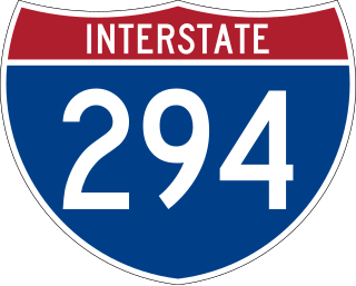
Interstate 294 (I-294) is a tolled auxiliary Interstate Highway in the northeastern part of the U.S. state of Illinois. Forming the southern portion of the Tri-State Tollway in Illinois, I-294 runs from South Holland at I-80/I-94 and Illinois Route 394 (IL 394) to Northbrook at I-94. I-294 is 53.42 miles (85.97 km) long; 5.32 miles (8.56 km) are shared with I-80. It serves as a bypass around the city of Chicago.

Illinois Route 72 is an east–west state highway in northern Illinois. It runs from the intersection with Illinois Route 73 north of Lanark east to Illinois Route 43 in Chicago. This is a distance of 110.71 miles (178.2 km).

Roads and expressways in Chicago summarizes the main thoroughfares and the numbering system used in Chicago and its surrounding suburbs.

Forest Glen is one of the 77 official city community areas of Chicago, Illinois, located on the city's Northwest Side. It comprises the neighborhoods of Forest Glen, Edgebrook and Sauganash, with sub-neighborhoods of Sauganash Park, Wildwood, North Edgebrook and Old Edgebrook.

Howard is an 'L' station in Chicago, Illinois on the North Side Main Line. It is the northern terminus of the Red Line and the southeastern terminus of the Yellow Line; it also serves the Purple Line, for which it is the southern terminus at non-rush hour times on weekdays and all day on weekends. Trains on the Chicago North Shore and Milwaukee Railroad also stopped at Howard from 1926 until that line was abandoned in 1963.
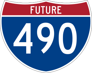
Interstate 490 (I-490), also known as the O'Hare West Bypass and Western O'Hare Beltway, is an electronic toll highway and a beltway that is currently under construction near Chicago, Illinois; it will run along the west side of O'Hare International Airport. The tollway will connect I-294 to a western access point to the airport. From there, it will continue northward to an extension of Illinois Route 390 and I-90. The O'Hare Western Bypass is part of the Elgin–O'Hare Western Access (EOWA) project. Building the highway will affect the villages of Elk Grove Village, Wood Dale, Itasca, and Bensenville. The route will run through the 1979 American Airlines Flight 191 crash site, the deadliest aviation accident in US history.
Cumberland is a station on the Chicago Transit Authority's 'L' system. Situated on the Blue Line between Rosemont and Harlem, the station is located in the median of the Kennedy Expressway at Cumberland Avenue in the O'Hare community area’s Schorsch Forest View neighborhood on Chicago's Northwest Side. It is also in close proximity to both the Norwood Park neighborhood and the city of Park Ridge as well as the village of Norridge. The area surrounding the station consists of mixed commercial and residential development.

Sheridan Road is a major north-south street that leads from Diversey Parkway in Chicago, Illinois, north to the Illinois-Wisconsin border and beyond to Racine. Throughout most of its run, it is the easternmost north-south through street, closest to Lake Michigan. From Chicago, it passes through Chicago's wealthy lakeside North Shore suburbs, and then Waukegan and Zion, until it reaches the Illinois-Wisconsin state line in Winthrop Harbor. In Wisconsin, the road leads north through Pleasant Prairie and Kenosha, until it ends on the south side of Racine, in Mount Pleasant.

U.S. Route 41 (US 41) in the U.S. state of Illinois runs north from the Indiana border beneath the Chicago Skyway on Indianapolis Boulevard to the Wisconsin border north of the northern terminus of the Tri-State Tollway with Interstate 94. It is the only north–south U.S. Route to travel through a significant portion of the city of Chicago, carrying Lake Shore Drive through the central portion of the city along the lakefront. US 41 in Illinois is 64.81 miles (104.30 km) in length.
The Golden Corridor is the area around the Jane Addams Memorial Tollway, formerly known as the Northwest Tollway, in the Chicago metropolitan area. Its name refers to the "gold" mine of economic profit for communities in the area. Several Fortune 500 company headquarters, office parks, industrial parks, exhibition and entertainment centers, medical facilities, hotels, shopping centers, and restaurants are in the Golden Corridor. With the exception of the O'Hare area of Chicago, all the communities in this region are part of a larger region known as the "Northwest Suburbs".
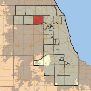
Elk Grove Township is one of 29 townships in Cook County, Illinois, USA. As of the 2020 census, its population was 95,508 and it contained 40,299 housing units. Elk Grove Township formerly housed the United Airlines headquarters.

Howard Street, alternately known as Sibley Street in Park Ridge, is a major east–west street in the Chicago metropolitan area. At Paulina Street, it houses the Howard CTA Station, the northern terminus of the Red Line, and, between Paulina Street and Kedzie Avenue, serves as the border between the city of Chicago and the city of Evanston. It runs intermittently through several north and northwestern suburbs, near O'Hare International Airport, and finally terminates at Ridge Avenue in Elk Grove Village. The street is located at 7600 N in Chicago's address system.
Phillip Rogers was a settler of Irish origin who migrated to the Chicago area from Watertown, New York in 1836. He built a cabin on Ridge Avenue and bought a tract of land in the unincorporated area now bounded by Touhy Ave., Western Ave., Ridge Ave., and Morse Ave. from the government for $1.25 an acre. He continued to accumulate land and eventually owned approximately 1,600 acres (6.5 km2), farming much of it.

The Peninsula Chicago is a hotel located at the intersection of East Superior Street and North Michigan Avenue in Chicago, Illinois. The hotel is part of The Peninsula Hotels group based in Hong Kong. The Peninsula Hotel group's parent Hongkong and Shanghai Hotels, who already owned 92.5% of the Chicago property's shares, purchased the remainder of the shares that it did not already own in late 2009, giving it full ownership of the hotel.

Wildwood is a neighborhood located in the Forest Glen Community Area on the Far Northwest side of Chicago, Illinois.
