
Bardiya District, one of the seventy-seven Districts of Nepal, is part of Lumbini Province of Nepal. The district, with Gulariya as its headquarters, covers an area of 2,025 km2 (782 sq mi) and according to the 2001 census the population was 382,649 in 2011 it has 426,576.
Dadeldhura, a part of Sudurpashchim Province, is one of the seventy-seven districts of Nepal. The district, with Dadeldhura as its district headquarters, covers an area of 1,538 km2 (594 sq mi) and had a population of 126,162 in 2001 and 142,094 in 2011.

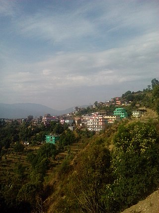
Dhankuta District is one of 14 districts of Koshi Province of eastern Nepal. The district covers an area of 891 km2 (344 sq mi) and has a population (2011) of 163,412. The hill town of Dhankuta serves as the district headquarters of Dhankuta District.
Gorkha District, a part of Gandaki Province, is one of 77 districts of Nepal, and the fourth largest district of the country in terms of area. It is historically linked with the creation of modern Nepal and the name of the legendary Gorkha soldiers. The district, with Gorkha Municipality as its district headquarters, covers an area of 3,610 km2 (1,390 sq mi) and has a population of 252,201, according to the 2021 Nepal census. Gorkha district is the site of the Manakamana Temple, as well as Gorakh Nath and Gorakh Kali temples. Several major rivers—including the Chepe, Daraudi, Marsyangdi, Budi Gandaki, and Trishuli—run through the district.
Ilam district is one of 14 districts of Koshi Province of eastern Nepal. It is a Hill district and covers 1,703 km2 (658 sq mi). The 2011 census counted 290,254 inhabitants. The municipality of Ilam is the district headquarters and is about 600 km (370 mi) from Kathmandu.

Jhapa District is a district of Koshi Province in eastern Nepal named after a Rajbanshi Surjapuri language word "Jhapa", meaning "to cover" (verb). The 2021 Nepal Census, puts the total population of the district at 994,090. The total area of the district is 1,606 square kilometres.
Kailali District, a part of Sudurpashchim Province in Terai plain, is one of the 77 districts of Nepal. The district, with Dhangadhi as its district headquarters, covers an area of 3,235 square kilometres (1,249 sq mi) and has a population 911,155 and, .

Khotang District is one of 14 districts of Koshi Province of eastern Nepal. The district, with Diktel as its district headquarters, covers an area of 1,591 km2 (614 sq mi) and has a population (2021) of 206,312. The district is bordered by Bhojpur District in the east, Udayapur District in the south, Okhaldhunga District in the west and Solukhumbu District in the North. In this district there are 2 municipalities and 8 rural/urban municipalities.

Lalitpur District (Nepali: ललितपुर जिल्ला, in Bagmati Province, is one of the seventy-seven districts of Nepal. The district, with Lalitpur as its district headquarters, covers an area of 396.92 km2 and has a population of 337,785. It is one of three districts in the Kathmandu Valley, along with Kathmandu and Bhaktapur. Its population was 466,784 in the initial 2011 census tabulation. It is surrounded by Makwanpur, Bhaktapur, Kathmandu and Kavre.
Mahottari District, a part of Madhesh Province, is one of the seventy-seven districts of Nepal. The district, with Jaleshwar as its district headquarter, covers an area of 1,002 km2 (387 sq mi) and had a population of 553,481 in 2001, 627,580 in 2011 and 705,838 in 2021 census. Its headquarters is located in Jaleshwar, a neighbouring town of the historical city of Janakpur. The name Jaleshwar means the 'God in Water'. One can find a famous temple of Lord Shiva in Water there. Jaleshwar lies at a few kilometres distance from the Nepal-India border and has a majority Maithili population.
Makwanpur District(Nepali: मकवानपुर जिल्ला;, in Bagmati Province, earlier a part of Narayani Zone, is one of the seventy-seven districts of Nepal. The city of Hetauda serves as the district headquarters and also as the provincial headquarters. The district covers an area of 2,426 km2 and had a population of 392,604 in 2001 and 420,477 in 2011. The latest census of 2021 recorded the population of Makwanpur as 466,073.

Okhaldhunga District is one of 14 districts of Koshi Province in eastern Nepal. The district, with the municipality of Okhaldhunga as its district headquarters, covers an area of 1,074.5 km2 (414.9 sq mi) and had a population of 156,702 in 2001 and 147,984 in 2011.

Sunsari District is one of 14 districts in Koshi province of eastern Nepal. The district is located in the eastern part of the Outer Terai and covers an area of 1,257 km2 (485 sq mi). According to the 2011 Nepal census, the population was 753,328. The district headquarters is located in Inaruwa.

A village development committee in Nepal was the lower administrative part of its Ministry of Federal Affairs and Local Development. Each district had several VDCs, similar to municipalities but with greater public-government interaction and administration. There were 3,157 village development committees in Nepal. Each village development committee was further divided into several wards depending on the population of the district, the average being nine wards.
Shivanagar is a town in Krishnanagar Municipality in Kapilvastu District in the Lumbini Zone of southern Nepal. The former VDC was merged to form the municipality established on 18 May 2014 Krishnanagar, Sirsihawa, Shivanagar VDCs. At the time of the 2011 Nepal census it had a population of 4,774 people living in 735 individual households.
Pathari Shanishchare (पथरी-शनिश्चरे) is a Municipality in Morang District in the Koshi Zone of south-eastern Nepal. It was formed by merging three existing village development committees i.e. Hasandaha, Pathari and Sanischare in May 2014.

Urlabari is a city and municipality in Morang District in the Koshi Zone of south-eastern Nepal. It is considered to be the second largest city in Morang District after Biratnagar. At the time of the 1991 Nepal census it had a population of 18,224. At the time of the 2011 Nepal census it had a population of 35,166 and 8,165 households.
Nepal conducted a widespread national census in 2011 by the Nepal Central Bureau of Statistics. Working with the 58 municipalities and the 3,915 Village Development Committees at a district level, they recorded data from all the municipalities and villages of each district. The data included statistics on population size, households, sex and age distribution, place of birth, residence characteristics, literacy, marital status, religion, language spoken, caste/ethnic group, economically active population, education, number of children, employment status, and occupation.
Sundar Haraicha is a municipality in Morang District of Koshi Province in Nepal. It is centered around Biratchowk town which is the gateway to Biratnagar. It borders Itahari Sub- Metropolitan city to the west, Dharan Sub- Metropolitan city to the Northwest and Belbari municipality to the east and is connected by Mahendra Highway. It is one of the fastest growing cities in eastern Nepal and the second largest city of Morang district after Biratnagar, with 121,305 inhabitants living in 26,677 households. It consists of the town centres of Biratchowk and Gothgaun which are parts of the Greater Birat Development Area which incorporates the cities of Biratnagar-Itahari-Gothgau-Biratchowk-Dharan primarily located on the Koshi Highway in Eastern Nepal, with an estimated total urban agglomerated population of 804,300 people living in 159,332 households.


