
The 2003 Atlantic hurricane season was a highly active Atlantic hurricane season with tropical activity before and after the official bounds of the season—the first such occurrence since the 1954 season. The season produced 21 tropical cyclones, of which 16 developed into named storms; seven of those attained hurricane status, of which three reached major hurricane status. With sixteen storms, the season was tied for the fifth-most active Atlantic hurricane season on record, although it has since dropped down to become the seventh most active season. The strongest hurricane of the season was Hurricane Isabel, which reached Category 5 status on the Saffir–Simpson hurricane scale northeast of the Lesser Antilles; Isabel later struck North Carolina as a Category 2 hurricane, causing $3.6 billion in damage and a total of 51 deaths across the Mid-Atlantic region of the United States.

The 2001 Atlantic hurricane season was a fairly active Atlantic hurricane season that produced 17 tropical cyclones, 15 named storms, nine hurricanes, and four major hurricanes. The season officially lasted from June 1, 2001, to November 30, 2001, dates which by convention limit the period of each year when tropical cyclones tend to form in the Atlantic Ocean basin. The season began with Tropical Storm Allison on June 4, and ended with Hurricane Olga, which dissipated on December 6. The most intense storm was Hurricane Michelle, which attained Category 4 strength on the Saffir–Simpson Hurricane Scale.

The 1975 Atlantic hurricane season featured the first tropical storm to be upgraded to a hurricane based solely on satellite imagery – Hurricane Doris. The season officially began on June 1 and lasted until November 30. These dates conventionally delimit the period of each year when most tropical cyclones form in the Atlantic basin. The season was near average, with nine tropical storms forming, of which six became hurricanes. Three of those six became major hurricanes, which are Category 3 or higher on the Saffir–Simpson scale. The first system, Tropical Depression One, developed on June 24. Tropical Storm Amy in July caused minor beach erosion and coastal flooding from North Carolina to New Jersey, and killed one person when a ship capsized offshore North Carolina. Hurricane Blanche brought strong winds to portions of Atlantic Canada, leaving about $6.2 million (1975 USD) in damage. Hurricane Caroline brought high tides and flooding to northeastern Mexico and Texas, with two drownings in the latter.

The 1979 Atlantic hurricane season was the first season to include both male and female names, as well as the common six-year rotating lists of tropical cyclone names. The season officially began on June 1, and lasted until November 30. These dates conventionally delimit the period of each year when most tropical cyclones form in the Atlantic basin. It was slightly below average, with nine systems reaching tropical storm intensity. The first system, an unnumbered tropical depression, developed north of Puerto Rico on June 9. Two days later, Tropical Depression One formed and produced severe flooding in Jamaica, with 40 deaths and about $27 million (1979 USD) in damage. Tropical Storm Ana caused minimal impact in the Lesser Antilles. Hurricane Bob spawned tornadoes and produced minor wind damage along the Gulf Coast of the United States, primarily in Louisiana, while the remnants caused flooding, especially in Indiana. Tropical Storm Claudette caused extensive flooding in Texas due to torrential rainfall, resulting in two deaths and about $750 million in damage.

Hurricane Anita was a powerful Atlantic hurricane during the otherwise quiet 1977 Atlantic hurricane season, and the latest first named storm on record since tropical cyclones were first named in 1950. The first tropical cyclone of the season, Anita developed from a tropical wave on August 29 in the north-central Gulf of Mexico. It tracked westward into an area with conditions favorable for further development, and quickly intensified into a hurricane by late on August 30. Initially, Anita was forecast to strike Texas, though a building ridge turned it to the west-southwest. The hurricane rapidly strengthened to attain peak winds of 175 mph (280 km/h), and on September 2 Anita made landfall in eastern Tamaulipas as a Category 5 hurricane. It quickly weakened as it crossed Mexico, and after briefly redeveloping into a tropical depression in the eastern Pacific Ocean, Anita dissipated on September 4 to the south of the Baja California Peninsula. Anita was the first major hurricane to form in The Gulf of Mexico since Hurricane Ethel of 1960.

The 2003 Pacific hurricane season was the first season to feature no major hurricanes – storms of Category 3 intensity or higher on the Saffir–Simpson hurricane wind scale (SSHWS) – since 1977. The dates conventionally delimiting the period when most tropical cyclones form in the Pacific Ocean are May 15 in the Eastern Pacific Ocean and June 1 in the Central Pacific, with the season ending on November 30. The 2003 season featured 16 tropical storms between May 19 and October 26; 7 of these became hurricanes, which is an average season. Damage across the basin reached US$129 million, and 23 people were killed by the storms.

The 1999 Pacific hurricane season was one of the least active Pacific hurricane seasons on record. The season officially began on May 15 in the Eastern Pacific, and on June 1 in the Central Pacific; in both basins, it ended on November 30. These dates conventionally delimit the period during which most tropical cyclones form in the northeastern Pacific Ocean. The first tropical cyclone of the season, Hurricane Adrian, developed on June 18, while the final storm of the season, Tropical Storm Irwin, dissipated on October 11. No storms developed in the Central Pacific during the season. However, two storms from the Eastern Pacific, Dora and Eugene, entered the basin, with the former entering as a hurricane.

The 1993 Pacific hurricane season was a slightly above-average Pacific hurricane season with seven named storms directly impacting land. The season officially started on May 15 in the eastern Pacific, and on June 1 in the central Pacific, and ended on November 30; these dates conventionally delimit the period during which most tropical cyclones form in the northeastern Pacific Ocean. The first tropical cyclone developed on June 11, over a month after the traditional start of the season. The final named storm of the season, Tropical Storm Norma, dissipated on October 14. The Central Pacific Ocean saw very little tropical activity, with only one cyclone, Hurricane Keoni, developing in that particular region. However, many storms out of the season crossed the threshold into the Central Pacific, many as hurricanes, and even major hurricanes.

The 1990 Pacific hurricane season was a very active season which observed 21 named storms within the basin. The season also produced the fourth highest ACE index value on record. The season was officially started on May 15 in the eastern Pacific, and on June 1 in the central Pacific, and lasted until November 30. These dates conventionally delimit the period of each year when most tropical cyclones form in the northeastern Pacific Ocean. However, the formation of tropical cyclones is possible at any time of the year, as illustrated in 1990 by the formation of the season's first named storm, Hurricane Alma, on May 12. At the time, this was the earliest formation of a tropical storm on record in the eastern Pacific
Hurricane Pauline was one of the deadliest Pacific hurricanes to make landfall in Mexico. The sixteenth tropical storm, eighth hurricane, and seventh major hurricane of the 1997 Pacific hurricane season, Pauline developed out of a tropical wave from Africa on September 16, 1997, moving across South America and into the Pacific Ocean. On October 5, the depression intensified into a tropical storm early the next day and by October 7, Pauline had reached hurricane intensity. It initially moved eastward, then turned northwestward and quickly strengthened to reach peak winds of 135 mph (215 km/h). It paralleled the Mexican coastline a short distance offshore before weakening and making landfall near Puerto Angel, on October 9, and dissipated the next day.

Hurricane Calvin was one of three Pacific hurricanes on record to make landfall along the Mexican coast during the month of July. The fourth tropical cyclone, third named storm, and second hurricane of the 1993 Pacific hurricane season, Calvin developed from an area of convection to the south of Mexico on July 4. The following day, the system intensified into a tropical storm, which was named Calvin. Continued strengthening ensued as Calvin curved from its initial westward track northward, and was upgraded to a hurricane on July 6 Calvin eventually turned northwest, and became a Category 2 hurricane on the Saffir–Simpson hurricane wind scale (SSHWS). By July 7, Hurricane Calvin made landfall near Manzanillo at peak strength. Calvin rapidly weakened after landfall, and was a tropical storm when it reemerged into the Pacific Ocean on early on July 8. Despite this, the hurricane did not reintensify, and continued to weaken as it headed rapidly northwestward. As Calvin made a second Mexican landfall near the southern tip of Baja California peninsula late on July 8, it weakened to a tropical depression. Early on July 9, the depression dissipated shortly after entering the Pacific Ocean for a third time.

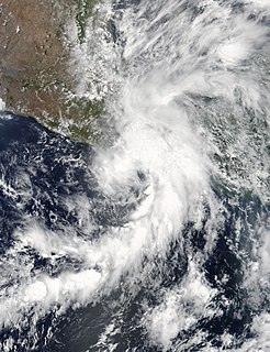
Tropical Storm Barbara was the first tropical cyclone to make landfall during the 2007 Pacific hurricane season. The second storm of the season, Barbara developed from a small low-pressure area on May 29 about 235 miles (380 km) southeast of Acapulco, Mexico. The system drifted southward before turning to a steadily eastward motion, and quickly intensified into a tropical storm. Increased wind shear weakened Barbara, though it re-organized to attain peak winds of 50 mph (80 km/h) before moving ashore just west of the border of Mexico and Guatemala. It rapidly weakened over land, and on June 2 the National Hurricane Center discontinued advisories on the storm. Despite expectations that the storm would attain hurricane status, Barbara moved ashore as a small, weak tropical storm. It produced locally heavy rainfall and gusty winds, and in most locations damage was minor. However, in southern Mexico, the rainfall destroyed large areas of cropland, with crop damage totaling 200 million pesos. In El Salvador, four people were killed by storm-induced floods.

Hurricane Rick was the second-latest hurricane ever to make landfall in Mexico. The eighteenth named storm, ninth and final hurricane of the 1997 Pacific hurricane season, Rick was a short-lived Category 2 hurricane on the Saffir-Simpson Hurricane Scale that weakened before making landfall in Mexico on November 10. It hit almost a month after the more powerful Hurricane Pauline made landfall in the same country. Most of the damage associated with Pauline was exacerbated by the weaker Rick, which struck during rebuilding efforts.

Hurricane Boris was the second of three storms to impact the Pacific coast of Mexico in June and July 1996. The fourth tropical cyclone and second hurricane of the 1996 Pacific hurricane season, Boris formed out of a tropical wave roughly 250 mi (400 km) south of the Gulf of Tehuantepec on June 27. The storm gradually intensified, becoming a tropical storm the following day and then hurricane on June 29. As the storm neared landfall, an eye developed and Boris reached its peak intensity with winds of 90 mph (150 km/h). Shortly after, the hurricane made landfall along the south coast of Mexico, between Lazaro Cardenas and Acapulco, at this intensity. Boris quickly weakened following its landfall, becoming a tropical depression roughly 18 hours later. The remnants of the system persisted until July 1, at which time it dissipated just offshore the Mexican coastline. Boris caused heavy flooding in southern Mexico that resulted in ten fatalities; however, a damage estimate is unknown.

Hurricane Bridget of June 1971 was one of the worst hurricanes to strike the Mexican city of Acapulco. It formed on June 14 as a tropical depression, which is a minimal tropical cyclone with winds less than gale force. However, it was soon upgraded to a tropical storm, and Bridget steadily intensified to become a hurricane on June 15. After peaking at Category 2 intensity, it weakened to a tropical storm on June 17, then made landfall in Mexico. Hours later, however, it turned offshore as a tropical depression. Bridget dissipated on June 20 after leaving heavy damage and 17 deaths in the Acapulco area.

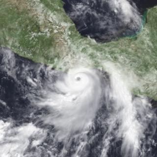
Tropical Storm Carlos was the first of five tropical cyclones to make landfall during the 2003 Pacific hurricane season. It formed on June 26 from a tropical wave to the south of Mexico. It quickly strengthened as it approached the coast, and early on June 27 Carlos moved ashore in Oaxaca with winds of 65 mph (100 km/h). The storm rapidly deteriorated to a remnant low, which persisted until dissipating on June 29. Carlos brought heavy rainfall to portions of southern Mexico, peaking at 337 mm (13.3 in) in two locations in Guerrero. Throughout its path, the storm damaged about 30,000 houses, with a monetary damage total of 86.7 million pesos. At least nine people were killed throughout the country, seven due to mudslides and two from river flooding; there was also a report of two missing fishermen.

Tropical Storm Olaf was an erratic and long-lived tropical cyclone that brought heavy rainfall to regions of Mexico, which would be devastated by Hurricane Pauline a week later. The sixteenth named storm of the 1997 season, Olaf formed on September 26 off the southern coast of Mexico. It moved northward and quickly intensified, reaching peak winds of 70 mph (120 km/h) before weakening and hitting Oaxaca as a tropical depression. In Mexico, El Salvador, and Guatemala, the system brought heavy rainfall, which killed 18 people and caused flooding and damage. It was originally thought that Olaf dissipated over Mexico, although its remnants continued westward for a week. It interacted with Hurricane Pauline, which caused Olaf to turn to the southeast and later to the north to strike Mexico again, finally dissipating on October 12.

Hurricane Carlotta was the easternmost tropical cyclone in the Eastern Pacific to make landfall at hurricane intensity since 1966. The third tropical cyclone and third named storm of the 2012 Pacific hurricane season, Carlotta developed slowly into a tropical depression from a tropical wave southwest of Central America on June 14. It moved generally west-northwestward and by the following day, strengthened into tropical storm strength. Thereafter, gradual intensification occurred and the storm reached hurricane strength on June 15. Rapid intensification ensued further, as Carlotta peaked as a 110 mph (175 km/h) Category 2 hurricane on the same day. At 0100 UTC the following day, Carlotta made landfall near Puerto Escondido, the easternmost landfalling Pacific hurricane in recorded history at the time. The next day the storm began to weaken as it moved onshore Southwestern Mexico. Carlotta continued to weaken rapidly, eventually dissipating on June 16.
Tropical Storm Beatriz was a short-lived tropical storm that made landfall in the Mexican state of Oaxaca in June 2017. The second named storm of the 2017 Pacific hurricane season, Beatriz developed from a tropical wave which had exited the coast of West Africa on May 18 and crossed Central America, and was designated as Tropical Depression Two-E on May 31. Shortly after being upgraded to a tropical storm, Beatriz made landfall near Puerto Angel, Mexico on the evening of June 1. It subsequently weakened into a tropical depression as it moved ashore, dissipating quickly afterwards.

Tropical Storm Vicente was an unusually small tropical cyclone that made landfall as a tropical depression in the Mexican state of Michoacán on October 23, 2018, causing deadly mudslides. The 21st named storm of the 2018 Pacific hurricane season, Vicente originated from a tropical wave that departed from Africa's western coast on October 6. The wave traveled westward across the Atlantic and entered the Eastern Pacific on October 17. The disturbance became better defined over the next couple of days, forming into a tropical depression early on October 19. Located in an environment favorable for further development, the system organized into Tropical Storm Vicente later that day.


