Hurricane Calvin (1993)

Last updated

Map key
  Tropical depression (≤38 mph, ≤62 km/h)
  Tropical storm (39–73 mph, 63–118 km/h)
  Category 1 (74–95 mph, 119–153 km/h)
  Category 2 (96–110 mph, 154–177 km/h)
  Category 3 (111–129 mph, 178–208 km/h)
  Category 4 (130–156 mph, 209–251 km/h)
  Category 5 (≥157 mph, ≥252 km/h)
  Unknown
Storm type
Disc Plain black.svg Tropical cyclone
Solid black.svg Subtropical cyclone
ArrowUp.svg Extratropical cyclone, remnant low, tropical disturbance, or monsoon depression

Hurricane Calvin originated from an area of disturbed weather, characterized with scattered deep convection, that developed south of the Gulf of Tehuantepec on the second day of July. Despite the lack of concentrated convection, the system was classified using the Dvorak technique, a tool used to measure a tropical cyclone's intensity. However, during the morning hours of July 4, banding features formed on the southern semicircle of the disturbance, and it is estimated that the system attained tropical depression status at 1200 UTC while centered approximately 315 mi (505 km) southeast of Acapulco. [3] Initially, the storm was expected to stay offshore and attain winds of 70 mph (115 km/h). [4] Intensifying within a favorable atmospheric environment, the depression attained tropical storm status at 0000 UTC on July 5, receiving the name Calvin. [3]

A period of rapid intensification ensued shortly thereafter, and banding-type eye formed in association with Calvin later that day. [3] By July 5, the National Hurricane Center (NHC) was predicting winds of 80 mph (130 km/h). [5] Later that day, the NHC reported winds of 65 mph (105 km/h). [6] Continuing to intensify, the system was upgraded to a hurricane at 0000 UTC on July 6 while becoming the second hurricane of the season, [6] though operationally, it was believed to have become a hurricane three hours earlier. Upon becoming a hurricane, the NHC revised their forecast and was now expecting Calvin to become a Category 3 hurricane on the SSHWS. [7] Around this time, Hurricane Calvin was embedded within the northeastern portion of a large, monsoon-like deep-layer-mean, which stretched from the Intertropical Convergence Zone to the southwest Mexican coastline. Furthermore, Calvin was a fairly large cyclone as surface winds of 35 mph (55 km/h) were reported over 200 mi (320 km) from the storm's center. [3]

During the late morning hours of July 6, Calvin briefly slowed down before quickly accelerating to the northwest, bringing Calvin's gale-force winds 90 mi (140 km) south-southwest of Acapulco. [6] [8] Later that day, the NHC upgraded Calvin into a Category 2 hurricane. [6] At 1200 UTC on July 7, Calvin reached its peak intensity of 100 mph (160 km/h) and a minimum barometric pressure of 966 mbar (28.5 inHg). [6] Shortly thereafter, Calvin made landfall, approximately 40 mi (65 km) west-northwest of Manzanillo. [1] The storm quickly weakened over land, and by the evening, it had weakened into a tropical storm. [6] After weakening greatly due to land interaction with the mountainous terrain of Mexico, Calvin reentered the Pacific at 0000 UTC on July 8. [1] Although initially expected to turn west, this did not occur. [9] Instead, Calvin continued northwest, accelerating while emerging into the Gulf of California. [6] Calvin weakened to a tropical depression late on July 8 as it made a second landfall along the extreme southern Baja California peninsula. After crossing the coast, Tropical Depression Calvin dissipated the next day atop of cold sea surface temperatures. [1]

Preparations

Prior to making landfall, a tropical storm warning and hurricane watch was issued for a portion of the Mexican coast on July 6. Six hours later, a hurricane warning was issued. By July 8, all hurricane warnings were discontinued. Six hours later, all hurricane watches were dropped. By 1800 UTC that day, all watches and warnings were dropped. [10] In addition to the watches and warnings, flash floods and mudslides to occur. [11] In Acapulco, hundreds of police and emergency workers were on stand by in advance of the storm. Meanwhile, the city's airport and ports were closed. Further south, in Oaxaca, the ports of Puerto Escondido, Puerto Ángel, Bahias de Huatulco, and Salina Cruz were closed. [12] As a precautionary measure, the port of Zihuatanejo was also closed. [13] In all, many sea ports were closed and airplane flights were canceled [14] leaving many vacationers stranded. [15] Multiple hotels were closed in the cities of Acapulco, Puerto Angel, and Huatulco. [16] While weakening, the storm also threatened ports such as Mazatlán along the Gulf of California coast. [17]

Impact

Calvin's rainfall across southern Mexico Calvin 1993 rainfall.png
Calvin's rainfall across southern Mexico

Due to the storm's large size, Hurricane Calvin was responsible for heavy flooding along much of the coast of Mexico, and after moving onshore as a hurricane, two locations (El Marques, Japala Del) reported as high as 18.27 in (464 mm) of rain. [18] The flooding led to mudslides, killing 28 people on land, with 30,000 people displaced. [19] Most of the casualties were indirect. [20] In all, 37 people perished due to Hurricane Calvin. [21] Nationwide 42,063 people were evacuated from their homes. [22] Numerous seaside restaurants were washed off their respective foundations. [23] Banana, mango, and corn plantations were also destroyed by the strong winds. [24] Coconut trees were reportedly brought down as well. [25]

In Puebla, a peasant died. [26] Inland, 16 persons were killed in the states of Mexico and San Luis Potosí, where heavy rains caused mudslides across higher elevations. [27] In the latter, 11 deaths were reported as two rivers had overflowed their banks while in the former, five people died. [28] Moreover, six people riding in a taxi died in Veracruz during Calvin. [29] Across Nayarit, Calvin brought heavy rains to the state. [30] Later in its duration, Calvin struck the Baja California peninsula, though the storm had weakened considerably by that time [6] Offshore, three ships containing 659 immigrants were intercepted by the storm, but the ship sustained no damage. [31]

In all, the damage from Hurricane Calvin amounted to over 100 million new pesos, or $32 million (1993 USD). [20] Despite the devastation, many vacationers did not alter their plans because of the hurricane. [32]

Oaxaca

Prior to affecting Guerrero, Hurricane Calvin was responsible for heavy rains and widespread flooding across Oaxaca. An estimated 7,000 were left homeless along the Oaxacan coast and on the Isthmus of Tehuantepec. In addition, travel from the isthmus was cut off due to mudslides that blocked portions of the Pan-American Highway. [12] Two rivers threatened to overflow their banks while the Benito, Juarez, and Yosocuta dams attained peak capacity and thus the gates were opened to prevent overflowing. A total of 42 communities were flooded. The cities of Tehuantepec, Salina Cruz, Juchtianm, and Tuxtepec were flooded due to extended periods of torrential rains. Across the state, the rains blocked highways and knocked out electrical, telephone, and water services. [13] About 3,000 people took refuge to shelters and one person was killed. [28]

Guerrero

In Acapulco, waves of 15 ft (4.6 m) moved through the city. In several states, between 5 in (130 mm) to 10 in (250 mm) inches of rain was recorded. However, in Las Pilas, the highest rainfall total was observed, at 16.34 in (415 mm). [1]

Prior to landfall, the storm's outer rainbands began to spread over the region, resulting in flooding. Throughout Acapulco, the storm uprooted 100 trees and caused some damage to roads. [12] Although the city escaped significant damage, [33] many huts were damaged and 1,600 people were left homeless. [28] Citywide six people were killed [26] while two other fisherman were missing. [34] A mudslide killed a man and a son [28] [35] one person was reported dead after trying to save his boat from sinking. In addition, 13 boats sunk due to high waves, which impeded all maritime activity along the coast. In the city of Zihuatanejo, heavy rains flooded streets; consequently, "waist-deep" water was reported in some parts of the city. As a result, tourists were evacuated to higher ground. [36] A total of 2,000 people were forced to abandon their homes. [37] Two people sustained minor injuries when a tree was uprooted. [38] Many neighborhoods throughout Acapulco were flooded. [39] Overall, several beach communities were destroyed, almost 1,000 dwellings were destroyed, thousands of people were left homeless, and many areas remained without electricity. [40]

Statewide, the majority of storm damage occurred over a 4 mi (6 km) stretch of road, which was situated about 25 mi (40 km) north of Acapulco. About a dozen small wood-built restaurants were swept away by high waves. At a nearby small beach resort, four cottages were damaged due to the winds and were later swept away. [27] One two-story hotel was nearly destroyed as all that remained undamaged after the storm was a swimming pool. [39] In a resort town situated 18 mi (29 km) northwest of the city, high waves pounded many small resorts. [41]

Colima

Following Calvin's closest approach to Manzanillo, the Mexican Weather Service station in the city recorded a minimum barometric pressure of 986.5 mbar (29.13 inHg), as well as 84 mph (135 km/h) surface winds as the center of Calvin passed a little to the west. The Instituto Oceanografico del Pacifico in Manzanillo reported a minimum central pressure of 994 mbar (29.4 inHg) in addition to gale-force winds. Statewide, sustained winds of 60 mph (97 km/h) were observed around 1300 UTC. Shortly thereafter, near 1545 UTC, sustained winds of 35 mph (56 km/h) with gusts up to 45 mph (72 km/h) were reported in Manzanillo. Offshore, several ships reported rough weather during Calvin's existence, with the Pacific Sandpiper reporting a maximum wave height of 44 ft (13 m). [1]

Two fatalities occurred offshore when a trimaran capsized; two fishermen were also reported missing. [20] [34] A pair children were killed by a mudslide. [37] [42] Damage to boats and shoreline structures extended from Acapulco to Manzanillo. [20] Electrical and water services were cut off to the city of Mazanillio. [30] In all, 4,000 people were evacuated from their homes throughout the state. [43] Several ports were also closed. [28] Throughout Colima, lime and mango crops sustained $4.3 million in damage. [40]

Michoacán

In the state of Michoacán, 700 homes were destroyed. Moreover, many bridges and highways were destroyed due to a 15 ft (4.6 m) storm surge. [44] A total of 4,000 persons fled their homes in Michoacan, including 3,000 alone in Lázaro Cárdenas. [28] Crop damage in both this state and Colima totaled to $7 million. [17] Numerous communities were completely evacuated. [40]

Although initially not expected to pose a threat to the chemicals on the ship Betula, [12] rough seas near Lázaro Cárdenas caused all 4,000 t (4,000,000 kg) of sulfuric acid to leak aboard the previously beached cargo tanker. [20] The tow line snapped when a tug was taking it out to sea. Two of the four tanks broke off by July 7. [26] The Mexican Navy then decided it would be best to tow the ship to shore and neutralize the battery acid that the ship contained. It was estimated that such project could take two weeks. [20] [27]

Jalisco

Shortly after making its first landfall, the storm moved over a sparsely populated portion of Mexico near Puerto Vallarta. Throughout the region from Manzanillo to Puerto Vallarta, no deaths were reported. However, phones and power services were disrupted and many roads were blocked due to extensive flooding. However, further details about impact could not be obtained due to lack of communication, though some places sustained waist-high water. [43] However, the resort city of Puerto Vallarta itself was spared, receiving just some rain and light winds. [34] About 60 mi (95 km) south of the city, numerous coastal roads were destroyed due to mudslides. [26] In all, 10 towns were flooded. [28]

Aftermath

During the aftermath of the storm, troops were called in to deliver aid to the victims of the storm. [26] A state of emergency was declared in at least ten states in Mexico following Calvin's passage. [20] Furthermore, Mexican officials implemented emergency measures with assistance of agencies such as the Mexican Army and the local health department in the most of the devastated areas. Civil protection authorities donated food to more than 40,000 people for three days. They distributed around 11,000 blankets, 5,000 mattresses, 8,000 sacks of sand to reinforce dikes, and an additional 20 t (20,000 kg) of food, medicine, and clothes. [45] Many Los Angeles residents looked for ways to donate aid to the needy. [46] Then-Mexican President Carlos Salinas de Gortari announced that the government would channel $11.4 million to three of the hardest-hit states. The government channeled $2.7 million to Guerrero alone (half of which was supplied to Acapulco) for reconstruction efforts. Michoacan was also expected to receive $4.7 million in aid while Colima was expected to acquire $4 million. [40]

Once the hurricane had moved away from the coast, airports quickly re-opened. [47] Simultaneously, fishermen in Playa Azul protested that their livelihood was endangered due to fishing bans caused by the chemical spill; consequently, in Lázaro Cárdenas, 28 people were arrested while warrants for 526 others' arrest were issued for disturbing peace and blocking highways. This sparked protests from two environmental group as a well a group of Mexican artists. Also, the fisherman demanded a $1 million compensation. [26] [48] Within a week after the storm, additional rains had moved into the area, leading to further damage and eight fatalities. [49]

See also

Related Research Articles

<span class="mw-page-title-main">Hurricane Cesar–Douglas</span> Category 4 Atlantic and Pacific hurricane in 1996

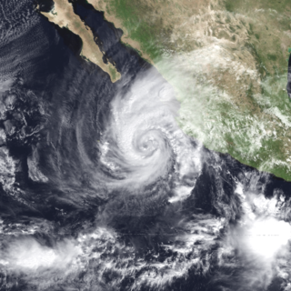
Hurricane Cesar–Douglas was one of the few tropical cyclones to survive the crossover from the Atlantic to east Pacific basin, and was the last to receive two names upon doing so. Hurricane Cesar was the third named storm and second hurricane of the 1996 Atlantic hurricane season. The system formed in the southern Caribbean Sea and affected several countries in South America before crossing Nicaragua and entering the Eastern Pacific where it was renamed Hurricane Douglas, the fourth named storm, third hurricane, and first and strongest major hurricane of the 1996 Pacific hurricane season. The storm killed 113 people in Central and South America and left 29 others missing, mainly due to flooding and mudslides.

<span class="mw-page-title-main">1992 Pacific hurricane season</span> Hurricane season in the Pacific Ocean

The 1992 Pacific hurricane season is the most active Pacific hurricane season on record, featuring 27 named storms, and the second-costliest Pacific hurricane season in history, behind the 2013 season. The season also produced the second-highest ACE value on record in the basin, only surpassed by the 2018 season. The season officially started on May 15 in the eastern Pacific, and on June 1 in the central Pacific, and lasted until November 30. These dates conventionally delimit the period of each year when most tropical cyclones form in the northeastern Pacific Ocean. However, these bounds were easily exceeded when Hurricane Ekeka formed on January 28 and again a couple months later with Tropical Storm Hali.

<span class="mw-page-title-main">1983 Pacific hurricane season</span> Hurricane season in the Pacific Ocean

The 1983 Pacific hurricane season was the longest season ever recorded at that time. It was a very active Pacific hurricane season. The season started on May 15, 1983 in the eastern Pacific, and on June 1, 1983 in the central Pacific, and lasted until November 30, 1983. These dates conventionally delimit the period of each year when most tropical cyclones form in the northeastern Pacific Ocean. During the 1983 season, there were 21 named storms, which was slightly less than the previous season. Furthermore, twelve of those storms became hurricanes. And eight of the storms reached major hurricane status, or Category 3 or higher on the Saffir–Simpson hurricane wind scale (SSHWS). The decaying 1982–83 El Niño event likely contributed to this level of activity. That same El Niño influenced a very quiet Atlantic hurricane season.

<span class="mw-page-title-main">1989 Pacific typhoon season</span> Typhoon season in the Pacific Ocean

The 1989 Pacific typhoon season was a highly above-average season. It has no official bounds; it ran year-round in 1989, but most tropical cyclones tend to form in the northwestern Pacific Ocean between May and November. These dates conventionally delimit the period of each year when most tropical cyclones form in the northwestern Pacific Ocean. Tropical Storms forming in the Western Pacific basin were assigned a name by the Joint Typhoon Warning Center. Tropical depressions that enter or form in the Philippine area of responsibility are assigned a name by the Philippine Atmospheric, Geophysical and Astronomical Services Administration or PAGASA. This can often result in the same storm having two names.

<span class="mw-page-title-main">Tropical Storm Bret (1993)</span> Atlantic tropical storm in 1993

Tropical Storm Bret was the deadliest natural disaster in Venezuela since the 1967 Caracas earthquake. The third tropical cyclone of 1993 Atlantic hurricane season, Bret formed on August 4 from a westward-moving, African tropical wave. Bret would later peak as a 60 mph (97 km/h) tropical storm as it neared Trinidad. It took an extremely southerly course through the Caribbean, passing over the coasts of Venezuela and Colombia. High terrain in the northern parts of those countries severely disrupted the circulation of the storm, and Bret had weakened to a tropical depression before emerging over the extreme southwestern Caribbean Sea. There, it restrengthened to a tropical storm and made landfall in Nicaragua on August 10, dissipating soon after. Bret's remnants reached the Pacific Ocean, where they ultimately became Hurricane Greg.

<span class="mw-page-title-main">Hurricane John (2006)</span> Category 4 Pacific hurricane

Hurricane John was a Category 4 hurricane that caused heavy flooding and extensive damage across most of the Pacific coast of Mexico in late August through early September 2006. John was the eleventh named storm, seventh hurricane, and fifth major hurricane of the 2006 Pacific hurricane season. Hurricane John developed on August 28 from a tropical wave to the south of Mexico. Favorable conditions allowed the storm to intensify quickly, and it attained peak winds of 130 mph (210 km/h) on August 30. Eyewall replacement cycles and land interaction with western Mexico weakened the hurricane, and John made landfall on southeastern Baja California Sur with winds of 110 mph (180 km/h) on September 1. It slowly weakened as it moved northwestward through the Baja California peninsula, and dissipated on September 4. Moisture from the remnants of the storm entered the southwest United States.

<span class="mw-page-title-main">Hurricane Greg (1999)</span> Category 1 Pacific hurricane in 1999

Hurricane Greg was the only eastern Pacific tropical cyclone in 1999 to make a direct landfall. Part of the annual hurricane season, Greg originated from a tropical wave that departed Africa in mid-August. The wave entered the eastern Pacific by September 1, steadily organizing over subsequent days to become a tropical depression on September 5. Amid a favorable environment, the cyclone intensified into Tropical Storm Greg a few hours after formation and further organized into a Category 1 hurricane on September 6. Greg paralleled the southwestern coastline of Mexico, where it destroyed over 250 homes, cut-off roads, killed 10 people, and left at least 4,000 more injured. The storm weakened to tropical storm intensity as it moved ashore Baja California Sur, although rain was generally beneficial there. Succumbing to cooler waters and high wind shear, Greg ultimately dissipated over the Pacific on September 9. Its remnants led to thunderstorms across northern California, with only minor impacts.

<span class="mw-page-title-main">Hurricane Boris (1996)</span>

Hurricane Boris was the second of three storms to impact the Pacific coast of Mexico in June and July 1996. The fourth tropical cyclone and second hurricane of the 1996 Pacific hurricane season, Boris formed out of a tropical wave roughly 250 mi (400 km) south of the Gulf of Tehuantepec on June 27. The storm gradually intensified, becoming a tropical storm the following day and then hurricane on June 29. As the storm neared landfall, an eye developed and Boris reached its peak intensity with winds of 90 mph (140 km/h). Shortly after, the hurricane made landfall along the south coast of Mexico, between Lazaro Cardenas and Acapulco, at this intensity. Boris quickly weakened following its landfall, becoming a tropical depression roughly 18 hours later. The remnants of the system persisted until July 1, at which time it dissipated just offshore the Mexican coastline. Boris caused heavy flooding in southern Mexico that resulted in ten fatalities; however, a damage estimate is unknown.

<span class="mw-page-title-main">Hurricane Hernan (1996)</span> Category 1 Pacific hurricane in 1996

Hurricane Hernan was fourth and final tropical cyclone to strike Mexico at hurricane intensity during the 1996 Pacific hurricane season. The thirteenth tropical cyclone, eighth named storm, and fifth hurricane of the season, Hernan developed as a tropical depression from a tropical wave to the south of Mexico on September 30. The depression quickly strengthened, and became Tropical Storm Hernan later that day. Hernan curved north-northwestward the following day, before eventually turning north-northeastward. Still offshore of the Mexican coast on October 2, Hernan intensified into a hurricane. Six hours later, Hernan attained its peak as an 85 mph (140 km/h) Category 1 hurricane on the Saffir-Simpson Hurricane Wind Scale (SSHWS). After weakening somewhat, on 1000 UTC October 3, Hurricane Hernan made landfall near Barra de Navidad, Jalisco, with winds of 75 mph (120 km/h). Only two hours after landfall, Hernan weakened to a tropical storm. By October 4, Tropical Storm Hernan had weakened into a tropical depression, and dissipated over Nayarit on the following day.

<span class="mw-page-title-main">Tropical Storm Julio (2002)</span> Tropical storm in 2002

Tropical Storm Julio was a weak and short-lived tropical storm that made landfall along the southern Mexican coast in September 2002. The twelfth named storm of the 2002 Pacific hurricane season, Julio originated from an area of convection that organized into a tropical depression on September 25. Initially forecast to stay offshore, the depression moved northward and strengthened into a tropical storm that same day. Julio turned to the northwest and peaked as a minimal tropical storm just before landfall near Lázaro Cárdenas, on September 26. The storm soon weakened into a tropical depression and rapidly dissipated over Mexico that day.

<span class="mw-page-title-main">Hurricane Virgil (1992)</span> Category 4 Pacific hurricane in 1992

Hurricane Virgil was a late season hurricane of the 1992 Pacific hurricane season that struck southwestern Mexico in October 1992. Forming from a tropical wave that left Africa on September 13, it slowly developed into a tropical depression. It soon strengthened into Tropical Storm Virgil, and rapidly intensified into a hurricane on October 2. Continuing to intensify, the hurricane attained major hurricane strength, and peaked as a Category 4 hurricane off the coast of Mexico. Shortly before landfall, it weakened to a Category 2 hurricane, and it dissipated on October 5. Damage was generally minimal, though one person was reported missing.

<span class="mw-page-title-main">Tropical Storm Carlos (2003)</span> Pacific tropical storm in 2003

Tropical Storm Carlos was the first of five tropical cyclones to make landfall during the 2003 Pacific hurricane season. It formed on June 26 from a tropical wave to the south of Mexico. It quickly strengthened as it approached the coast, and early on June 27 Carlos moved ashore in Oaxaca with winds of 65 mph (105 km/h). The storm rapidly deteriorated to a remnant low, which persisted until dissipating on June 29. Carlos brought heavy rainfall to portions of southern Mexico, peaking at 337 mm (13.3 in) in two locations in Guerrero. Throughout its path, the storm damaged about 30,000 houses, with a monetary damage total of 86.7 million pesos. At least nine people were killed throughout the country, seven due to mudslides and two from river flooding; there was also a report of two missing fishermen.

<span class="mw-page-title-main">Tropical Storm Olaf (1997)</span> Pacific tropical storm in 1997

Tropical Storm Olaf was an erratic and long-lived tropical cyclone that brought heavy rainfall to regions of Mexico, which would be devastated by Hurricane Pauline a week later. The sixteenth named storm of the 1997 season, Olaf formed on September 26 off the southern coast of Mexico. It moved northward and quickly intensified, reaching peak winds of 70 mph (110 km/h) before weakening and hitting Oaxaca as a tropical depression. In Mexico, El Salvador, and Guatemala, the system brought heavy rainfall, which killed 18 people and caused flooding and damage. It was originally thought that Olaf dissipated over Mexico, although its remnants continued westward for a week. It interacted with Hurricane Pauline, which caused Olaf to turn to the southeast and later to the north to strike Mexico again, finally dissipating on October 12.

<span class="mw-page-title-main">Hurricane Adrian (1999)</span> Category 2 Pacific hurricane in 1999

Hurricane Adrian caused generally minor damage along its path in mid-June 1999, though it left six people dead in its wake. The first tropical cyclone and first hurricane of the well below-average 1999 Pacific hurricane season, Adrian formed out of a broad area of low pressure south of the Gulf of Tehuantepec that persisted for several days. The disturbance was intertwined with a tropical wave that departed the western coast of Africa on June 5, and both features congealed into a tropical depression by early on June 18. The nascent cyclone paralleled the southwestern coastline of Mexico, intensifying into Tropical Storm Adrian shortly after formation and attaining its peak as a Category 2 hurricane with winds of 100 mph (160 km/h) late on July 20. Though remaining offshore, it resulted in minor flooding and insignificant damage to infrastructure. Four people were killed by a large wave along the coastline of Chiapas, and an additional two people were killed in Durango while trying to cross a flooded river in a pick-up truck; a five-year-old girl accompanying the men went missing. Wind shear and cooler ocean temperatures weakened Adrian as it produced minor damage on Socorro Island, and the system ultimately degenerated into a remnant low late on June 22.

<span class="mw-page-title-main">Hurricane Winifred</span> Category 3 Pacific hurricane in 1992

Hurricane Winifred was the last tropical cyclone to make landfall in the record-breaking 1992 Pacific hurricane season. Impacting western Mexico, especially Colima and Michoacán, Hurricane Winifred brought heavy rain and destruction to the area. Rains flooded farms and roads, and caused more than $5 million in damage and a total of three people were killed.

<span class="mw-page-title-main">Hurricane Eugene (1987)</span> Category 2 Pacific hurricane in 1987

Hurricane Eugene was the only tropical cyclone to make landfall in Mexico during the 1987 Pacific hurricane season. The eighth tropical cyclone, fifth named storm, and first hurricane of the season, Eugene developed on July 22 from a tropical disturbance centered well offshore of Mexico. Later that day, the system intensified into a tropical storm while moving northwestward. Eugene reached hurricane status on July 24; it briefly peaked as a Category 2 hurricane the next day. Hurricane Eugene weakened back to a Category 1 hurricane; subsequently, the hurricane made landfall near Manzanillo. Shortly after landfall, Eugene rapidly weakened inland, and was only a tropical storm when it re-emerged into open water, where it quickly dissipated. Throughout southwestern Mexico, the storm produced high winds, especially in the southwestern portion of the country. The hurricane deluged the southwest Mexican coastline, resulting in the highest rainfall totals from a tropical cyclone in five Mexican states. Over 5,000 people were left homeless, including 60 in Manzanillo. The city's airport control tower was also damaged, requiring closure. Elsewhere, 200 to 300 houses were destroyed in Colima. In all, Eugene injured 18 people, and caused three fatalities and $142.12 million (1987 USD) in damage.

<span class="mw-page-title-main">Hurricane Jova (2011)</span> Category 3 Pacific hurricane in 2011

Hurricane Jova was a strong Pacific hurricane that made landfall in Jalisco, Mexico in October 2011. The cyclone was the tenth named storm, ninth hurricane, and fifth major hurricane of the 2011 Pacific hurricane season. Jova developed from a tropical disturbance that formed on October 5. The disturbance steadily organized and acquired more thunderstorm activity over the following hours, and it became a tropical depression early on October 6. It strengthened into Tropical Storm Jova later that day. Moving generally northward, wind shear initially inhibited the system until the establishment of more favorable conditions on October 8 allowed Jova to begin to intensify. It reached hurricane strength that day as it drifted eastwards, and reached major hurricane status on October 10 after a period of steady intensification. Jova reached peak intensity the following day as a high-end Category 3 hurricane, with maximum sustained winds of 125 mph (205 km/h), and a minimum barometric pressure of 955 mbar (28.20 inHg). Jova weakened somewhat as it approached the coastline of Mexico, and made landfall near Barra de Navidad, Jalisco on October 12 as a Category 2 hurricane. The storm rapidly weakened as it moved inland and dissipated the next morning.

<span class="mw-page-title-main">Hurricane Odile (1984)</span> Category 2 Pacific hurricane in 1984

Hurricane Odile was the second of three tropical storms to make landfall in Mexico during the 1984 Pacific hurricane season. The fifteenth named storm and twelfth hurricane of the active season, it developed from a tropical disturbance about 185 miles (298 km) south of Acapulco on September 17. Curving towards the northwest, Odile became a Category 1 hurricane on September 19. The tropical cyclone reached its peak intensity with winds of 105 mph (169 km/h) two days later; however, Hurricane Odile began to weaken as moved erratically it encountered less favorable conditions and was downgraded to a tropical storm shortly before making landfall northwest of Zihuatanejo. Over land, the storm rapidly weakened, and dissipated on September 23. The storm caused significant rainfall accumulations of 24.73 inches (628 mm) in Southern Mexico, resulting in severe damage to tourism resorts. Flooding from Odile resulted in the evacuation of 7,000 people, 21 deaths, and the damage of about 900 homes.

<span class="mw-page-title-main">Tropical Storm Beatriz (2017)</span> Pacific tropical storm in 2017

Tropical Storm Beatriz was a short-lived tropical storm that made landfall in the Mexican state of Oaxaca in June 2017. The second named storm of the 2017 Pacific hurricane season, Beatriz developed from a tropical wave which had exited the coast of West Africa on May 18 and crossed Central America, and was designated as Tropical Depression Two-E on May 31. Shortly after being upgraded to a tropical storm, Beatriz made landfall near Puerto Angel, Mexico on the evening of June 1. It subsequently weakened into a tropical depression as it moved ashore, dissipating quickly afterwards.

<span class="mw-page-title-main">Tropical Storm Narda (2019)</span>

Tropical Storm Narda was a short-lived tropical storm that remained close to the Pacific coast of Mexico, causing flash flooding and mudslides in southwestern Mexico and the Baja California Peninsula in late September 2019. The fourteenth named storm of the 2019 Pacific hurricane season, Narda developed from a broad area of low pressure that formed off the Central American Pacific coast on September 26. The broad low gradually organized as it moved west-northwestward, and it became Tropical Storm Narda early on September 29 while located off the southern coast of Mexico. The cyclone strengthened slightly before it moved inland near Manzanillo. Narda weakened to a tropical depression after moving inland, but restrengthened into a tropical storm on September 30 as it emerged over the Pacific Ocean just south of the Gulf of California. Narda quickly strengthened, and reached its peak intensity with winds of 50 mph (85 km/h) that day before making a second landfall along the northwestern coast of Mexico. The tropical cyclone weakened rapidly as it moved along the coastline, and it weakened to a tropical depression before dissipating just off the coast of Sonora on October 1.

References

  1. 1 2 3 4 5 6 Edward N. Rappaport (August 2, 1993). "Hurricane Calvin Preliminary Report". National Hurricane Center. p. 2. Retrieved March 6, 2011.
  2. Blake, Eric S; Gibney, Ethan J; Brown, Daniel P; Mainelli, Michelle; Franklin, James L; Kimberlain, Todd B; Hammer, Gregory R (2009). Tropical Cyclones of the Eastern North Pacific Basin, 1949-2006 (PDF). Archived from the original on July 28, 2013. Retrieved June 14, 2013.
  3. 1 2 3 4 Edward N. Rappaport (August 2, 1993). Hurricane Calvin Preliminary Report (Report). National Hurricane Center. p. 1. Retrieved March 6, 2011.
  4. Richard Pasch (July 4, 1993). "Tropical Depression Four-E Discussion 1". National Hurricane Center. Retrieved July 1, 2013.
  5. Edward N. Rappaport (July 5, 1993). Tropical Storm Calvin Discussion 3 (Report). National Hurricane Center. Retrieved July 1, 2013.
  6. 1 2 3 4 5 6 7 8 National Hurricane Center; Hurricane Research Division; Central Pacific Hurricane Center. "The Northeast and North Central Pacific hurricane database 1949–2021". United States National Oceanic and Atmospheric Administration's National Weather Service. A guide on how to read the database is available here PD-icon.svg This article incorporates text from this source, which is in the public domain .
  7. Richard Pasch (July 5, 1993). Hurricane Calvin Discussion 5 (Report). National Hurricane Center. Retrieved July 1, 2013.
  8. Edward N. Rappaport (July 6, 1993). Hurricane Calvin Discussion 7 (Report). National Hurricane Center. Retrieved July 1, 2013.
  9. Lixion Avila (July 6, 1993). Hurricane Calvin Discussion 13 (Report). National Hurricane Center. Retrieved July 1, 2013.
  10. Edward N. Rappaport (August 2, 1993). "Hurricane Calvin Preliminary Report". National Hurricane Center. p. 6. Retrieved March 6, 2011.
  11. Connie Chung (July 6, 1993). "Hurricane Calvin Threatening Southwest Coast of Mexico". CBS News Transcripts. CBS Evening News.  via Lexis Nexis (subscription required)
  12. 1 2 3 4 "Strong Winds Lash Acapulco as Hurricane Calvin Heads Toward Coast". International news. Associated Press. July 7, 1993.
  13. 1 2 "Hurricane Calvin whips Mexican coast". International. United Press Intentional. July 6, 1993.
  14. "Hurricane Calvin kills 28 people". Beaver County Times . July 9, 1993. Retrieved October 2, 2012.
  15. John Roberts (July 7, 1993). "Hurricane Calvin Moving on up Mexico's Pacific Coast". CBS News Transcripts. CBS Morning News.  via Lexis Nexis (subscription required)
  16. "Hurricane lashes resorts, moves north". Miami Herald . July 7, 1993. p. 8.
  17. 1 2 "Hurricane Calvin causes $7 million in crop damage in two Mexican states". BC cycle. United Press International. July 8, 1993.  via Lexis Nexis (subscription required)
  18. David M. Roth (July 19, 2007). Hurricane Calvin Rainfall (Report). Hydrometeorological Prediction Center . Retrieved September 23, 2012.
  19. Dartmouth College; Flood Observatory (July 2003). 1993 Global Register of Extreme Flood Events (Report). Archived from the original on December 16, 2013. Retrieved September 23, 2012.
  20. 1 2 3 4 5 6 7 Edward N. Rappaport (August 2, 1993). "Hurricane Calvin Preliminary Report". National Hurricane Center. p. 2. Retrieved March 6, 2011.
  21. "Death toll 37 as storm heads out to sea". L.A. Times . July 9, 1993. p. A14.
  22. Antia Snow (July 8, 1993). "Hurricane Calvin Heads to Sea After Mauling Mexico's Pacific Coast". AM cycle. Associated Press.  via Lexis Nexis (subscription required)
  23. "Hurricane Calvin heads to Baja California". Rome News-Tribune . July 8, 1993. Retrieved October 2, 2012.
  24. "Hurricane Calvin heads for land". The Mount Airy News . July 9, 1993. Retrieved October 2, 2012.
  25. "Hurricane Calvin pounds Mexican coast". Bangor Daily News . July 8, 1993. Retrieved October 2, 2012.
  26. 1 2 3 4 5 6 "Hurricane Calvin pounds Mexico's west coast". Agence France Presse. July 7, 1993.  via Lexis Nexis (subscription required)
  27. 1 2 3 Bill Comier (July 6, 1993). "Strong Winds Lash Acapulco as Hurricane Calvin Heads Toward Coast". AM cycle. Associated Press.  via Lexis Nexis (subscription required)
  28. 1 2 3 4 5 6 7 "Calvin headed to open sea after wreaking havoc on Pacific coast". BC cycle (International). United Press International. July 7, 1993.
  29. "Hurricane Cavlin Kills 19". The Herald. July 8, 1993.  via Lexis Nexis (subscription required)
  30. 1 2 "Calvin headed to open sea after wreaking havoc on Pacific coast". BC cycle (International news). July 7, 1993.  via Lexis Nexis (subscription required)
  31. "3 Immigrant Ships Intercepted off Baja". San Jose Mercury News. July 8, 1993. p. 3A Front.
  32. "Calvin Not Scaring Away Tourists". Sacramento Bee . July 8, 1993. p. A12.
  33. "Strong winds lash Acapulco". The Times-News. Associated Press. July 7, 1993. p. 7. Retrieved May 11, 2013.
  34. 1 2 3 Antia Snow (July 8, 1993). "Hurricane Skips Past Puerto Vallarta, Heads Toward Baja California". The Associated Press.
  35. Bill Cromier (July 7, 1993). "Hurricane Calvin Pounds Mexico's Pacific Coast; 28 Dead" (International news). Associated Press.
  36. "Hurricane Calvin pounds Mexico". Gadsden Times. Associated Press. July 6, 1993. Retrieved May 10, 2013.
  37. 1 2 "Hurricane Claims More Lives". Press Association Limited. Press Association. July 7, 1993.
  38. "Hurricane Calvin heads for Mexico's west coast". Agence France Presse. July 7, 1993.
  39. 1 2 "Storm". Gainesville Sun. July 8, 1993. pp. 37, 1A. Retrieved May 11, 2013.
  40. 1 2 3 4 "Hurricane Calvin dissipates after devastating Mexican coast". BC Cycle (International news). United Press International. July 9, 1993.  via Lexis Nexis (subscription required)
  41. "Calvin lashes Mexico". The Post and Courier. July 7, 1993. Retrieved May 11, 2013.
  42. "Hurricane Calvin causes $7 million in crop damage in two Mexican states". BC cycle. United Press International. July 8, 1883.  via Lexis Nexis (subscription required)
  43. 1 2 "Pacific storm displaces thousands". Saraosta Herald-Tribune. Associated Press. July 7, 1993. p. 118. Retrieved May 10, 2013.
  44. Lixion A. Avila; Max Mayfield (March 1995). "Eastern North Pacific Hurricane Season of 1993". Monthly Weather Review. 123 (3): 897–906. Bibcode:1995MWRv..123..897A. doi: 10.1175/1520-0493(1995)123<0897:ENPHSO>2.0.CO;2 .
  45. "Mexico: Killer Hurricanes Leaves Trail of Death and Destruction". IPS-Inter Press Service. July 8, 1993.  via Lexis Nexis (subscription required)
  46. "Southland looks for ways to assist storm victims". L.A. Times . July 9, 1993. p. A14.
  47. "Hurricane Calvin swirls along Mexico's west coast". USA Today . July 8, 1993. p. 4A.
  48. "Fishermen arrested for protesting shipwreck losses". BC cycle. United Press International. July 8, 1993.  via Lexis Nexis (subscription required)
  49. "Heavy rain blamed for 7 deaths". Oxnard Press-Courier. July 14, 1993. p. 6.  via Lexis Nexis (subscription required)
Hurricane Calvin
Calvin 1993-07-06 1831Z.png
Calvin near peak intensity off the southern coast of Mexico on July 6