
The 1970 Atlantic hurricane season officially began on June 1 and lasted until November 30. These dates conventionally delimit the period of each year when most tropical cyclones form in the Atlantic basin. The season was fairly average, with 14 named storms forming, of which seven were hurricanes. Two of those seven became major hurricanes, which are Category 3 or higher on the Saffir–Simpson scale. Also, this was the first season in which reconnaissance aircraft flew into all four quadrants of a tropical cyclone.

The 2003 Pacific hurricane season was the first season to feature no major hurricanes – storms of Category 3 intensity or higher on the Saffir–Simpson hurricane wind scale (SSHWS) – since 1977. The dates conventionally delimiting the period when most tropical cyclones form in the Pacific Ocean are May 15 in the Eastern Pacific Ocean and June 1 in the Central Pacific, with both seasons ending on November 30. The 2003 season featured 16 tropical storms between May 19 and October 26; 7 of these became hurricanes, which was then considered an average season. Damage across the basin reached US$129 million, and 23 people were killed by the storms.

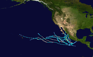
The 1992 Pacific hurricane season is the most active Pacific hurricane season on record, featuring 27 named storms, and the second-costliest Pacific hurricane season in history, behind the 2013 season. The season also produced the second-highest ACE value on record in the basin, only surpassed by the 2018 season. The season officially started on May 15 in the eastern Pacific, and on June 1 in the central Pacific, and lasted until November 30. These dates conventionally delimit the period of each year when most tropical cyclones form in the northeastern Pacific Ocean. However, these bounds were easily exceeded when Hurricane Ekeka formed on January 28 and again a couple months later with Tropical Storm Hali.
The 1981 Pacific hurricane season was a slightly below average Pacific hurricane season. The season officially started on May 15 in the eastern Pacific basin and June 1 in the central Pacific basin. Both basins' seasons ended on November 30; these dates conventionally delimit the period during which most tropical cyclones form in the northeastern Pacific Ocean. The first tropical cyclone of the season was designated on May 30, and the final storm of the season, Hurricane Otis, dissipated on October 30. The season produced fifteen named storms and a total of eight hurricanes, which was near normal. However, the total of one major hurricane was below the average of three.

The 1973 Pacific hurricane season was an event in tropical cyclone meteorology. The most important system this year was Hurricane Ava, which was the most intense Pacific hurricane known at the time. Several other much weaker tropical cyclones came close to, or made landfall on, the Pacific coast of Mexico. The most serious of these was Hurricane Irah, which downed power and communication lines in parts of the Baja California Peninsula; the other landfalling storms caused rain and some flooding. No tropical cyclone this season caused any deaths.

The 1974 Pacific hurricane season featured one of the most active periods of tropical cyclones on record with five storms existing simultaneously. The season officially started May 15 in the eastern Pacific, and June 1 in the central Pacific, and lasted until November 30. These dates conventionally delimit the period of each year when most tropical cyclones form in the northeast Pacific Ocean.

A Pacific hurricane is a tropical cyclone that develops within the northeastern and central Pacific Ocean to the east of 180°W, north of the equator. For tropical cyclone warning purposes, the northern Pacific is divided into three regions: the eastern, central, and western, while the southern Pacific is divided into 2 sections, the Australian region and the southern Pacific basin between 160°E and 120°W. Identical phenomena in the western north Pacific are called typhoons. This separation between the two basins has a practical convenience, however, as tropical cyclones rarely form in the central north Pacific due to high vertical wind shear, and few cross the dateline.

The 2008 Pacific hurricane season was a near-average Pacific hurricane season which featured seventeen named storms, though most were rather weak and short-lived. Only seven hurricanes formed and two major hurricanes. This season was also the first since 1996 to have no cyclones cross into the central Pacific. The season officially began on May 15 in the eastern Pacific and on June 1 in the central Pacific. It ended in both regions on November 30. These dates, adopted by convention, historically describe the period in each year when most tropical cyclone formation occurs in these regions of the Pacific. This season, the first system, Tropical Storm Alma, formed on May 29, and the last, Tropical Storm Polo, dissipated on November 5.

The 1967 Pacific hurricane season started on June 1 and ended on November 30, 1967. The season was of little note except for Hurricanes Katrina and Olivia. Katrina made landfall on the Baja Peninsula, killing at least one and made 2,500 homeless. Olivia made landfall on the eastern side of the Baja Peninsula as a major hurricane—only one of two storms ever to do so. Hurricane/Typhoon Sarah formed in the Central Pacific and reached category 1 strength before crossing over to the Western Pacific.

The 1966 Pacific hurricane season started on May 15, 1966, and ended November 30, 1966. The season was of little note. Hurricane Blanca traveled 4,300 miles, setting a new record. During September and October of the year, Hurricane Helga and Tropical Storms Kirsten, Lorraine, and Maggie hitting Mexico. Kirsten caused 8 deaths and US$5.6 million in damages in Mexico.

The 1963 Pacific hurricane season was a below-average season, with 8 storms and 4 hurricanes forming. The season ran through the summer and fall of 1963.

The 2009 Pacific hurricane season was the most active Pacific hurricane season since 1997. The season officially started on May 15 in the East Pacific Ocean, and on June 1 in the Central Pacific; they both ended on November 30. These dates conventionally delimit the period of each year when most tropical cyclones form in the Pacific basin. The first tropical cyclone to form was One-E on June 18, and the last, Hurricane Neki, dissipated on October 27.

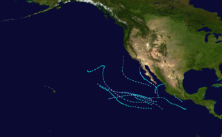
The 2013 Pacific hurricane season was the first to see twenty named storms since 2009 but also had the ninth fewest ACE units on record, as many of the storms were weak and short-lived. The season officially began on May 15 in the Eastern Pacific and started on June 1 in the Central Pacific; both ended on November 30. These dates conventionally delimit the period of each year when most tropical cyclones form east of the International Dateline in the North Pacific basin. The first cyclone, Tropical Storm Alvin, formed on May 15, and the last, Tropical Storm Sonia, dissipated on November 4.

The 2014 Pacific hurricane season was the fifth-busiest season since reliable records began in 1949, alongside the 2016 season. The season officially started on May 15 in the East Pacific Ocean, and on June 1 in the Central Pacific; they both ended on November 30. These dates conventionally delimit the period of each year when most tropical cyclones form in the Pacific basin.
The 1965 Pacific hurricane season officially started May 15, 1965, in the eastern Pacific, and June 1, 1965, in the central Pacific, and lasted until November 30, 1965. These dates conventionally delimit the period of each year when most tropical cyclones form in the northeast Pacific Ocean. A total of ten systems were observed. The most notable storm was Tropical Storm Hazel, which killed six people in Mexico.

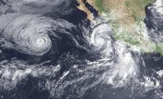
Hurricane Hilary was a Category 3 hurricane during the 1993 Pacific hurricane season that brought significant rainfall to the Sonoran Desert region of Mexico and the United States in August of that year. Additionally, its remnants in part caused significant flooding in the Midwestern United States. A westward moving tropical depression gradually developed on August 17 south of the Mexican coast, attaining hurricane status two days later. The storm further intensified into a Category 3 hurricane, attaining peak winds of 120 mph (195 km/h). By August 23, the hurricane nearly stalled while interacting with Tropical Storm Irwin. Executing a small counter-clockwise loop, Hilary degraded to tropical storm intensity and took a northerly track for the remainder of its existence. The storm made two landfalls in Mexico, one in Baja California Sur on August 25 and one in Sonora the following day. Tropical cyclone warnings and watches were issued for much of the southern Mexican coastline; however, they were later discontinued when the threat ended, but were issued again when the system posed a threat to the Baja California Peninsula. Hilary dropped in excess of 5 in (130 mm) rain along its path in some areas, and flash flooding in California and Iowa.

The 2018 Pacific hurricane season was one of the most active Pacific hurricane seasons on record, producing the highest accumulated cyclone energy value on record in the basin. The season had the fourth-highest number of named storms – 23, tied with 1982. The season also featured eight landfalls, six of which occurred in Mexico. The season officially began on May 15 in the Eastern Pacific, and on June 1 in the Central Pacific; they both ended on November 30. These dates conventionally delimit the period of each year when most tropical cyclones form in the Pacific basin. However, tropical cyclone formation is possible at any time of the year, as illustrated when the first tropical depression formed on May 10, five days prior to the official start of the season.
During 1993, tropical cyclones formed within seven different bodies of water called basins. To date, 110 tropical cyclones formed, of which 78 were given names by various weather agencies. Only one Category 5 tropical cyclone was formed in 1993.


