
Typhoon Haitang, known in the Philippines as Super Typhoon Feria, was the first super typhoon of the 2005 season in the northwestern Pacific. It had winds up to 260 km/h (160 mph) at peak intensity, and caused over 18 serious injuries and 15 confirmed deaths in Taiwan and the People's Republic of China. Damage totaled about $1.17 billion (2005 USD), most of which occurred in mainland China.

The September 2009 Vietnam tropical depression was a weak tropical depression that caused deadly flooding throughout central Vietnam in early September. Forming out of an area of low pressure on September 3, the depression hardly intensified as it meandered off the coast of Vietnam. Initially situated in a favorable environment, convective banding features began to develop and shower and thunderstorm activity formed near the center. On September 4, the Joint Typhoon Warning Center issued a Tropical Cyclone Formation Alert; however, a sudden increase in wind shear caused the system to rapidly become disorganized, leading to the cancellation of the alert the next day. The system continued to slowly track off the coast of Vietnam, nearly dissipating on September 5, before becoming better organized. However, the depression remained weak, with the JTWC reporting on September 7 that the depression had dissipated, though the Japan Meteorological Agency (JMA) continued to issue advisories until the depression dissipated during September 9.

The 2019 Pacific typhoon season was a devastating season that became the costliest on record, just ahead of the previous year and 2023, mainly due to the catastrophic damage wrought by typhoons Lekima, Faxai, and Hagibis. The season featured fairly above-average tropical cyclone activity for the second consecutive year, producing 29 named storms, 17 typhoons, and five super typhoons. The season's first named storm, Pabuk, reached tropical storm status on January 1, becoming the earliest-forming tropical storm of the western Pacific Ocean on record, breaking the previous record that was held by Typhoon Alice in 1979. The season's first typhoon, Wutip, reached typhoon status on February 20. Wutip further intensified into a super typhoon on February 23, becoming the strongest February typhoon on record, and the strongest tropical cyclone recorded in February in the Northern Hemisphere. The season's last named storm, Phanfone, dissipated on December 29 after it made landfall in the Philippines.
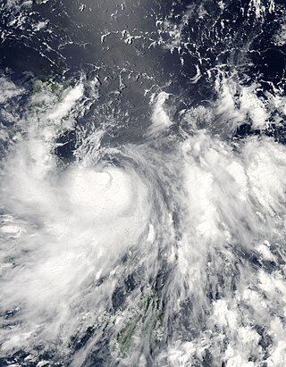
Typhoon Conson, known in the Philippines as Typhoon Basyang, was the second tropical cyclone during the 2010 Pacific typhoon season to impact the Philippines. Developing out of a tropical disturbance east of the Philippines on July 11, 2010, Conson quickly developed as it tracked nearly due west. Favorable environmental conditions, such as low wind shear and warm sea surface temperatures, allowed the system to intensify into a severe tropical storm by July 12. Around the same time, the JTWC assessed the storm to have been equivalent to a Category 1 hurricane. The following day, Conson struck Quezon Province with winds of 100 km/h (60 mph) before weakening. After crossing the archipelago, the storm entered the South China Sea where it was able to re-strengthen. By July 16, Conson attained typhoon status as it neared the southern Chinese island of Hainan. After brushing the island at peak intensity with sustained winds estimated at 130 km/h (80 mph), the storm weakened in the Gulf of Tonkin due to less favorable conditions. The storm eventually made landfall near Hanoi, Vietnam on July 17 and dissipated the following day.

The 2020 Pacific typhoon season was the first of a series of four below average Pacific typhoon seasons, and became the first with below-average tropical cyclone activity since 2014, with 23 named storms, 10 of which became typhoons and only 2 became super typhoons. This low activity was a consequence of La Niña that persisted from the summer of the year. It had the sixth-latest start in the basin on record, slightly behind 1973, and was the first to start that late since 2016. The first half of the season was unusually inactive, with only four systems, two named storms and one typhoon at the end of July. Additionally, the JTWC recorded no tropical cyclone development in the month of July, the first such occurrence since reliable records began. Despite that, this season featured Super Typhoon Goni, which made the strongest landfall worldwide in terms of 1-minute wind speed. The season's first named tropical cyclone, Vongfong, developed on May 8, while the season's last named tropical cyclone, Krovanh, dissipated on December 24. However, the season's last system was an unnamed tropical depression which dissipated on December 29.

Tropical Depression 18W was a tropical depression that impacted Vietnam, Laos and Thailand during mid September 2013. The system was first noted as a tropical depression on September 16, 2013, while it was located within the South China Sea to the south east of Hanoi in Vietnam. Over the next two days the system gradually developed further, before it was reported by the Vietnamese National Centre for Hydro Meteorological Forecasting that the system had developed into their eighth tropical storm of 2013. However, other meteorological agencies did not report that the system had developed into a tropical storm.

Tropical Storm Vamco was a weak tropical cyclone which affected Indochina in mid-September 2015. Formed from a tropical disturbance on September 13, the system developed into a tropical storm and reached its peak intensity on September 14. Vamco made landfall in Vietnam and affected Laos, Thailand and Cambodia. The storm caused flooding in these countries and damages amounted to US$14.1 million. Fifteen people died in the floods.

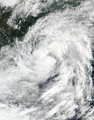
Severe Tropical Storm Mirinae was a tropical cyclone of moderate intensity that struck Hainan Island, China and Northern Vietnam in late July 2016. The third named storm of the annual typhoon season, Mirinae formed on July 25, 2016 as a tropical depression west of Luzon, Philippines. On July 26, it moved west-northwestwards, and it had intensified into a tropical storm before making landfall on Hainan Island, China. After passing over Hainan, it intensified into a severe tropical storm and made landfall over the Red River Delta in Northern Vietnam late on July 27, and dissipated the next day.

Tropical Storm Sonca was a weak tropical cyclone that impacted Southeast Asia during the end of July 2017. As the 10th named storm of the 2017 Pacific typhoon season, Tropical Storm Sonca formed south of Hong Kong, after drifting westward for multiple days, the storm intensified into a tropical storm, receiving the name Sonca. The storm later affected Hainan, reaching its peak intensity. On July 25, the storm made landfall over the Quảng Trị province, then dissipated.

Typhoon Doksuri, known in the Philippines as Tropical Storm Maring, was a strong Category 2 typhoon that mostly impacted the Philippines and Vietnam during mid-September 2017. Forming as the nineteenth named storm of the season, Doksuri developed as a weak tropical depression over to the east of Visayas on September 10.

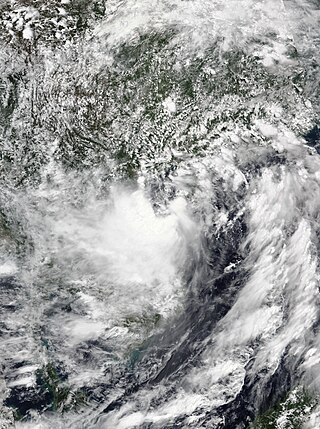
The October 2017 Vietnam tropical depression, also known officially by its designation as Tropical Depression 23W, was a weak but deadly system that brought torrential rainfall and extreme flooding over northern and central Vietnam in October 2017. The depression formed on October 7, located to the northwest of Luzon, Philippines. The system moved in a general westward direction as it steadily intensified. Despite being forecast to strengthen into a tropical storm, 23W failed to reach this intensity, due to lack of organization as it made landfall in Hà Tĩnh Province on October 10.

Typhoon Damrey, known in the Philippines as Severe Tropical Storm Ramil, was a strong tropical cyclone that affected the Philippines and Vietnam during early November 2017. Damrey first originated as a tropical depression over the Philippine archipelago of Visayas on October 31. Emerging into the South China Sea a few days later, the system strengthened into the second deadliest and twenty-third named storm of the 2017 Pacific typhoon season. Rapidly intensifying, Damrey became the season's tenth typhoon on November 3, reaching its peak intensity as a Category 2 on the same day. Damrey made landfall over Khánh Hoà, Vietnam on November 4 and began to rapidly weaken, fully dissipating on November 5.

Tropical Storm Pabuk, also referred to as Cyclonic Storm Pabuk, was a weak storm that struck the Malay Peninsula in January 2019. It was also the earliest-forming storm in both the Northwestern Pacific Ocean and North Indian Ocean basins on record. Forming on the last day of 2018, Pabuk persisted into 2019, spanning two calendar years, and crossed into the North Indian Ocean basin several days later. The first tropical cyclone and named storm of the 2019 Pacific typhoon and North Indian Ocean cyclone seasons, Pabuk originated as a tropical disturbance in the South China Sea on December 28, 2018, which organized into a tropical depression on December 31. A day later, on January 1, 2019, the system intensified into a tropical storm and was named Pabuk. Pabuk made landfall in Thailand on January 4, emerging into the Bay of Bengal in the North Indian Ocean basin shortly afterward. Pabuk weakened after it entered the North Indian Ocean, eventually degenerating into a remnant low on January 7, before dissipating on the next day.

Tropical Storm Sinlaku was a weak tropical cyclone that impacted Vietnam, Thailand and Laos in August 2020. Beginning as a tropical depression on July 31 in the South China Sea, Sinlaku was the fifth storm of the 2020 Pacific typhoon season. It gradually organized as it took a slow west-northwest course, strengthening into a tropical storm the following day despite its monsoonal structure. The storm subsequently made landfall in Vietnam as a broad but weak tropical storm. Persistent land interaction weakened Sinlaku, leading to its dissipation on August 3.

Tropical Storm Noul, also known in the Philippines as Tropical Storm Leon, was a weak, but deadly tropical cyclone that impacted central Vietnam, which had been affected by Tropical Storm Sinlaku more than one month earlier. Noul originated from a tropical system in the Philippine Sea in September 15. The system was upgraded into a tropical depression later that same day by JMA, with JTWC and PAGASA following suit in 15:00 UTC, with PAGASA assigning the local name Leon to the developing tropical cyclone. As Leon was leaving the area of responsibility, Leon intensified into a tropical storm and was assigned the international name Noul by JMA. Noul would make landfall between Quảng Trị and Thừa Thiên-Huế provinces in September 18 before degenerating into a remnant low over Thailand later that day.
Tropical Storm Nangka, also known in the Philippines as Tropical Depression Nika, was a weak tropical cyclone which would be the wettest tropical cyclone in the Western Pacific on record, producing 127.8 in of rainfall in Hướng Hóa, Vietnam. Nangka would impact Hainan and parts of Indochina, which had been affected by Tropical Storm Linfa just days earlier. Nangka in total caused 4 deaths and 5 missing in China and Vietnam.

The 2020 Central Vietnam floods were a series of floods in Central Vietnam, which also affected some areas in Cambodia and Laos in October and early November 2020. The floods focused heavily in several provinces including Thừa Thiên Huế, Hà Tĩnh, Quảng Bình, Quảng Trị, and Quảng Ngãi. The floods were mainly caused by the seasonal monsoon, though enhanced by numerous tropical cyclones.
Tropical Storm Koguma was a weak tropical cyclone that made landfall in Vietnam, causing minor damage. The fourth named storm of the 2021 Pacific typhoon season, the system was first noted as an area of persistent convection on the South China Sea on June 10, with the JTWC assessing the system in its first advisory as a monsoon depression. Tracking west-northwestward, marginally conductive environmental conditions in the area allowed slight intensification while drifting towards Hainan Island. On the next day, the JMA upgraded the system to a tropical depression as it passed to the south of the territory before the agency upgraded the system to a tropical storm on June 12, being assigned the name Koguma. The JTWC; however still treated the system as a tropical depression until 12:00 UTC that day. It continued to move northwest over the warm waters of the Gulf of Tonkin, eventually making landfall in Vietnam over Thanh Hóa by the end of the same day, rapidly weakening afterward.

Vietnam is a southeast Asian country, and is the easternmost country of mainland Southeast Asia. It borders the South China Sea, hence, seeing the increased likeliness of tropical cyclones. Tropical cyclones in this area are considered to be part of the Northwest Pacific basin, and therefore, storms here are considered as typhoons.

Typhoon Yagi, known in the Philippines as Severe Tropical Storm Enteng, was a deadly and extremely destructive tropical cyclone which impacted Southeast Asia and South China in early September 2024. Yagi, which means goat or the constellation of Capricornus in Japanese, was the eleventh named storm, the first violent typhoon, and the first super typhoon of the annual typhoon season. It was one of the most intense typhoons ever to strike Northern Vietnam, the strongest typhoon to strike Hainan during the meteorological autumn, and the strongest since Rammasun in 2014. It is one of the four Category 5 super typhoons recorded in the South China Sea, alongside Pamela in 1954, Rammasun in 2014 and Rai in 2021.

