Pontotoc County is in the south central part of Oklahoma. As of the 2010 census, the population was 37,492. Its county seat is Ada. The county was created at statehood from part of the Chickasaw Nation in Indian Territory. It was named for a historic Chickasaw tribal area in Mississippi. According to the Encyclopedia of Oklahoma History and Culture, Pontotoc is usually translated "cattail prairie" or "land of hanging grapes."

Union County is a county located in the U.S. state of Mississippi. As of the 2010 census, the population was 27,134. Its county seat is New Albany. According to most sources, the county received its name by being a union of pieces of several large counties, like other Union counties in other states. However, other sources say that the name was meant to mark the re-union of Mississippi and the other Confederate states after the Civil War.
Pontotoc County is a county located in the U.S. state of Mississippi. As of the 2010 census, the population was 29,957. Its county seat is Pontotoc. It was created on February 9, 1836 from lands ceded to the United States under the Chickasaw Cession. Pontotoc is a Chickasaw word meaning "land of hanging grapes". The original Natchez Trace and the current-day Natchez Trace Parkway both pass through the southeast corner of Pontotoc County.

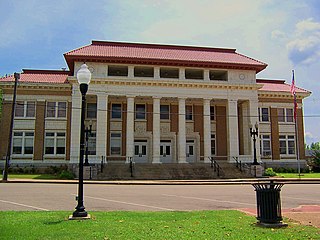
Chickasaw County is a county located in the U.S. state of Mississippi. As of the 2010 census, the population was 17,392. Its county seats are Houston and Okolona. The county is named for the Chickasaw people, who lived in this area for hundreds of years. Most were forcibly removed to Indian Territory in the 1830s, but some remained and became citizens of the state and the United States.
Houston is a city in and one of two county seats of Chickasaw County, in northern Mississippi, United States. The population was 3,623 at the 2010 census.

Okolona is a city in and one of the two county seats of Chickasaw County, Mississippi, United States. It is located near the eastern border of the county. The population was 2,692 at the 2010 census.

Tupelo is a city in, and the county seat of, Lee County, Mississippi, United States. With an estimated population of 38,312 in 2019, Tupelo is the sixth-largest city in Mississippi and is considered a commercial, industrial, and cultural hub of North Mississippi.
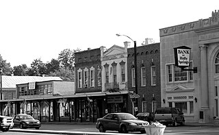
Holly Springs is a city in and the county seat of Marshall County, Mississippi, United States, at the border with southern Tennessee. Near the Mississippi Delta, the area was developed by European Americans for cotton plantations and was dependent on enslaved Africans. After the American Civil War, many freedmen continued to work in agriculture but as sharecroppers and tenant farmers.
The Meridian campaign or Meridian expedition took place from February 3 – March 6, 1864, from Vicksburg, Mississippi to Meridian, Mississippi, by the Union Army of the Tennessee, led by Maj. Gen. William Tecumseh Sherman. Sherman captured Meridian, Mississippi, inflicting heavy damage to it. The campaign is viewed by historians as a prelude to Sherman's March to the Sea in that a large swath of damage and destruction was inflicted on Central Mississippi as Sherman marched across the state and back.
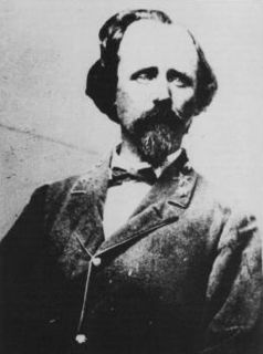
Brigadier-General Joseph Robert Davis was a senior officer of the Confederate States Army who commanded infantry in the Eastern Theater of the American Civil War.

The 3rd Illinois Cavalry Regiment was a cavalry regiment that served in the Union Army during the American Civil War. It fought at such battles as Pea Ridge, Sherman's Yazoo Campaign, The Battle of Port Gibson, and the Siege of Vicksburg.
The 3rd Tennessee Volunteer Cavalry Regiment was a cavalry regiment that served in the Union Army during the American Civil War.

Edward Mayes was the Chancellor of the University of Mississippi from 1887 to 1891.

Edmund Richardson was an American entrepreneur who acquired great wealth during the mid-19th century by producing and marketing cotton in the states of Mississippi, Louisiana, and Arkansas. At the time of his death, he was described as the richest man in the South.
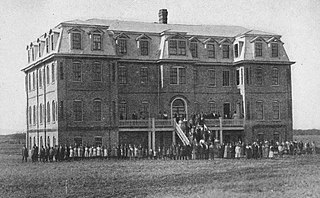
Okolona College, also known as Okolona Industrial School, and Okolona Normal & Industrial School, was a college for African Americans in Okolona, Mississippi, Chickasaw County, Mississippi. It was added to the National Register of Historic Places on August 9, 2002. The school is located on Mississippi Highway 245 1.1 miles north of the junction with Mississippi Highway 32 and Mississippi Highway 41. It is part of The Okolona College Historic District.
David Hunt was an American planter based in the Natchez District of Mississippi who controlled 25 plantations, thousands of acres and more than 1,000 slaves in the antebellum era. From New Jersey, he joined his uncle in Mississippi business. He became a major philanthropist in the South, contributing to educational institutions in Mississippi, as well as the American Colonization Society and Mississippi Colonization Society, of which he was a founding member.

Oakland College was a Presbyterian-affiliated four-year college reserved for whites; it operated from 1830 to 1861 near Lorman, Mississippi. After years of closure during the American Civil War of 1861–1865 and a failure to reorganize following the war, it was closed down.
The Skirmish at Terre Noire Creek, also known as the Skirmish at Wolf Creek or Skirmish at Antoine, an engagement during the Camden Expedition of the American Civil War, was fought on April 2, 1864. The action occurred about 1 mile (1.6 km) east of Terre Noire Creek along a defile near the towns of Hollywood, Arkansas and Antoine, Arkansas. A Confederate States Army cavalry brigade under Brigadier General Joseph O. Shelby attacked a Union supply train of more than 200 wagons accompanying Union Army Major General Frederick Steele's force which was attempting to reach Shreveport, Louisiana to join with Major General Nathaniel Banks's force in the Red River Campaign with the objective of occupying Shreveport and controlling western Louisiana.
Mississippi Highway 41 (MS 41) is a state highway in northeastern Mississippi. The route starts at U.S. Route 45 and US 278 north of Wren and travels westwards. It then intersects US 45 Alt. east of Okolona. The road enters Okolona, and intersects MS 32 and MS 245. MS 41 then turns northwest and travels toward Pontotoc. Once inside the city, the route turns north at MS 15 and travels through downtown Pontotoc. MS 41 ends at its intersection with MS 9 and MS 338. The route that became MS 41 was first used as an Indian trail. The route was designated by 1932 from Amory to Pontotoc, and it was truncated from Amory to US 45 by 1955. The entirety of MS 41 was paved by 1958.