Algoma, Mississippi

Last updated

Algoma, Mississippi
AlgomaMS.JPG
The Algoma water tower in Algoma, Mississippi. Photo by Michael Jones.
Flag of Algoma, Mississippi.png
Pontotoc County Mississippi Incorporated and Unincorporated areas Algoma Highlighted.svg
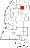
Location of Algoma, Mississippi
Usa edcp location map.svg
Red pog.svg
Algoma, Mississippi
Location in the United States
Coordinates: 34°10′32″N89°1′56″W / 34.17556°N 89.03222°W / 34.17556; -89.03222
Country United States
State Mississippi
County Pontotoc
Area
[1]
  Total6.62 sq mi (17.15 km2)
  Land6.59 sq mi (17.08 km2)
  Water0.03 sq mi (0.07 km2)
Elevation
417 ft (127 m)
Population
 (2020)
  Total705
  Density106.90/sq mi (41.27/km2)
Time zone UTC-6 (Central (CST))
  Summer (DST) UTC-5 (CDT)
ZIP code
38820
Area code 662
FIPS code 28-00820
GNIS feature ID0666194

Algoma is a town in Pontotoc County, Mississippi. The population was 705 at the 2020 census, up from 590 at the 2010 census.

Contents

Algoma is a Native American[ clarification needed ] word meaning "vale of flowers".[ citation needed ]

Geography

Algoma is located at 34°10′32″N89°01′56″W / 34.175574°N 89.032126°W / 34.175574; -89.032126 . [2]

According to the United States Census Bureau, the town has a total area of 6.6 square miles (17 km2), of which 6.6 square miles (17 km2) is land and 0.04 square miles (0.10 km2) (0.60%) is water.

Climate

The climate in this area is characterized by hot, humid summers and generally mild to cool winters. According to the Köppen Climate Classification system, Algoma has a humid subtropical climate, abbreviated "Cfa" on climate maps. [3]

Demographics

2020 census

As of 2020, there were 705 people, 333 households, and 234 families residing in the town. [4]

2000 census

As of the census [5] of 2000, there were 508 people, 203 households, and 156 families residing in the town. The population density was 77.2 inhabitants per square mile (29.8/km2). There were 222 housing units at an average density of 33.7 per square mile (13.0/km2). The racial makeup of the town was 77.17% White, 21.65% African American, and 1.18% from two or more races. Hispanic or Latino of any race were 2.36% of the population.

There were 203 households, out of which 33.5% had children under the age of 18 living with them, 61.6% were married couples living together, 13.8% had a female householder with no husband present, and 22.7% were non-families. 20.7% of all households were made up of individuals, and 9.4% had someone living alone who was 65 years of age or older. The average household size was 2.50 and the average family size was 2.90.

Historical population
CensusPop.Note
1990 420
2000 50821.0%
2010 59016.1%
2020 70519.5%
U.S. Decennial Census [6]

In the town, the population was spread out, with 25.0% under the age of 18, 9.3% from 18 to 24, 29.7% from 25 to 44, 21.5% from 45 to 64, and 14.6% who were 65 years of age or older. The median age was 36 years. For every 100 females, there were 88.8 males. For every 100 females age 18 and over, there were 85.9 males.

The median income for a household in the town was $32,333, and the median income for a family was $38,250. Males had a median income of $24,625 versus $18,750 for females. The per capita income for the town was $13,213. About 10.6% of families and 15.0% of the population were below the poverty line, including 15.4% of those under age 18 and 37.7% of those age 65 or over.

Education

The town of Algoma is served by the Pontotoc County School District. [7]

Algoma Cross Tie Festival

The first weekend in October Algoma has its annual "Algoma Cross Tie Festival". This festival is open for all people with live local music, auction, car and tractor show, and selling booths. The Cross-Tie Festival was originally begun in reference to the H. B. Owen Cross-Tie Factory. It was owned by Hardiman Brackett Owen in Algoma, Pontotoc Co., MS. The factory was one of the south's largest industries. Algoma still celebrates with "The Cross-Tie Festival" each year.

Notable people

Related Research Articles

<span class="mw-page-title-main">Pontotoc County, Mississippi</span> County in Mississippi, United States

Pontotoc County is a county located in the U.S. state of Mississippi. As of the 2020 census, the population was 31,184. Its county seat is Pontotoc. It was created on February 9, 1836, from lands ceded to the United States under the Chickasaw Cession. Pontotoc is a Chickasaw word meaning "land of hanging grapes". The original Natchez Trace and the current-day Natchez Trace Parkway both pass through the southeast corner of Pontotoc County.

<span class="mw-page-title-main">Lee County, Mississippi</span> County in Mississippi, United States

Lee County is a county in U.S. state of Mississippi. At the 2020 census, the population was 83,343. Its county seat is Tupelo. Lee County is included in the Tupelo Micropolitan Statistical Area.

<span class="mw-page-title-main">Bon Air, Alabama</span> Town in Alabama, United States

Bon Air is a town in Talladega County, Alabama, United States. It incorporated in 1932. At the 2010 census the population was 116, up from 96 in 2000.

<span class="mw-page-title-main">Chatom, Alabama</span> City in and county seat of Washington County, Alabama

Chatom is a town in Washington County, Alabama, United States. It incorporated in 1949. Chatom is the county seat of Washington County, holding the distinction since 1907. The town's population was 1,288 At the 2010 census, up from 1,193 in 2000.

<span class="mw-page-title-main">Delta, Louisiana</span> Village in Louisiana, United States

Delta is a village in Madison Parish, Louisiana, United States. The population was 232 at the 2020 census. It is part of the Tallulah Micropolitan Statistical Area.

<span class="mw-page-title-main">Allagash, Maine</span> Town in the state of Maine, United States

Allagash is a town in Aroostook County, Maine, United States. It is on the Allagash River in the North Maine Woods region.

<span class="mw-page-title-main">Mardela Springs, Maryland</span> Town in Maryland, United States

Mardela Springs is a town in Wicomico County, Maryland, United States. The population was 357 at the 2010 census. It is included in the Salisbury, Maryland-Delaware Metropolitan Statistical Area.

<span class="mw-page-title-main">Hickory Flat, Mississippi</span> Town in Mississippi, United States

Hickory Flat is a town in Benton County, Mississippi, United States. The population was 601 at the 2010 census.

<span class="mw-page-title-main">Carrollton, Mississippi</span> Town in Mississippi, United States

Carrollton is a town in and the second county seat of Carroll County, Mississippi, United States, which is within the Mississippi Delta. The population was 190 at the 2010 census, down from 408 in 2000. Centrally located in the county, the town is part of the Greenwood, Mississippi micropolitan area. The first county seat, Vaiden, was founded in the eastern part of the county during its early settlement.

<span class="mw-page-title-main">Houston, Mississippi</span> City in Mississippi, United States

Houston is a city and one of two county seats of Chickasaw County, in northeastern Mississippi, United States. The population was 3,623 at the 2010 census.

<span class="mw-page-title-main">Ecru, Mississippi</span> Town in Mississippi, United States

Ecru is a town in Pontotoc County, Mississippi. The population was 895 at the 2010 census. Ecru is home to the largest upholstered furniture plant in the world which manufactures Ashley Furniture.

<span class="mw-page-title-main">Thaxton, Mississippi</span> Town in Mississippi, United States

Thaxton is a town in Pontotoc County, Mississippi, United States. The population was 643 at the 2010 census.

<span class="mw-page-title-main">Kosciusko, Mississippi</span> City in Mississippi, United States

Kosciusko is a city in Attala County, Mississippi, United States. The population was 7,402 at the 2010 census. It is the county seat of Attala County.

<span class="mw-page-title-main">Toccopola, Mississippi</span> Town in Mississippi, United States

Toccopola is a town in Pontotoc County, Mississippi, United States. The population was 246 at the 2010 census.

<span class="mw-page-title-main">Burnsville, West Virginia</span> Town in West Virginia, United States

Burnsville is a town in Braxton County, West Virginia, United States, at the confluence of the Little Kanawha River and Saltlick Creek. The population was 401 at the 2020 census. Burnsville was incorporated in 1902 by the Circuit Court and named for Captain John Burns who operated the first sawmill in that section of the state and who established the town shortly after the close of the American Civil War. It was named "All West Virginia City" in 1976.

<span class="mw-page-title-main">Jane Lew, West Virginia</span> Town in West Virginia, United States

Jane Lew is a town in Lewis County, West Virginia, United States. The population was 409 at the time of the 2020 census.

<span class="mw-page-title-main">Hamlin, West Virginia</span> Town in West Virginia, United States

Hamlin is a town in and the county seat of Lincoln County, West Virginia, United States, along the Mud River. The population was recorded as 1,040 at the 2020 census. It is part of the Huntington–Ashland metropolitan area.

<span class="mw-page-title-main">Henderson, West Virginia</span> Unincorporated Town in West Virginia, United States

Henderson is an unincorporated community and former town in Mason County, West Virginia, United States, at the confluence of the Ohio and Kanawha Rivers. The population was 231 at the 2020 census. It is part of the Point Pleasant, WV–OH Micropolitan Statistical Area. The town was incorporated in 1893 and named for Samuel Bruce Henderson, who owned the townsite at the time. The town was unincorporated following a public hearing on August 11, 2022.

<span class="mw-page-title-main">Marlinton, West Virginia</span> Town in West Virginia, United States

Marlinton is a town in and the county seat of Pocahontas County, West Virginia, United States. The population was 998 at the 2020 census. Located along the Greenbrier River, it is known for its scenery.

<span class="mw-page-title-main">Sherman, Mississippi</span> Town in Mississippi, United States

Sherman is a town which straddles Lee, Pontotoc, and Union counties in Mississippi. The population was 600 at the 2020 census.

References

  1. "2020 U.S. Gazetteer Files". United States Census Bureau. Retrieved July 24, 2022.
  2. "US Gazetteer files: 2010, 2000, and 1990". United States Census Bureau. February 12, 2011. Retrieved April 23, 2011.
  3. "Algoma, Mississippi Koppen Climate Classification (Weatherbase)". Weatherbase.com.
  4. "Algoma town, Mississippi". United States Census Bureau. Retrieved April 15, 2023.
  5. "U.S. Census website". United States Census Bureau . Retrieved January 31, 2008.
  6. "Census of Population and Housing". Census.gov. Retrieved June 4, 2015.
  7. "2020 CENSUS - SCHOOL DISTRICT REFERENCE MAP: Pontotoc County, MS" (PDF). U.S. Census Bureau. Archived (PDF) from the original on August 1, 2022. Retrieved July 31, 2022. - Text list
  8. Edwards, David Honeyboy (2000). The World Don't Owe Me Nothing: The Life and Times of Delta Bluesman Honeyboy Edwards. Chicago Review Press. ISBN   9781556529825.