Thaxton, Mississippi

Last updated

Thaxton, Mississippi
Thaxton, Mississippi.jpg
Pontotoc County Mississippi Incorporated and Unincorporated areas Thaxton Highlighted.svg
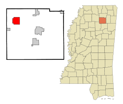
Location of Thaxton, Mississippi
Usa edcp location map.svg
Red pog.svg
Thaxton, Mississippi
Location in the United States
Coordinates: 34°18′26″N89°10′28″W / 34.30722°N 89.17444°W / 34.30722; -89.17444
Country United States
State Mississippi
County Pontotoc
Area
[1]
  Total
10.47 sq mi (27.12 km2)
  Land10.38 sq mi (26.87 km2)
  Water0.10 sq mi (0.25 km2)
Elevation
[2]
430 ft (130 m)
Population
 (2020)
  Total
692
  Density66.70/sq mi (25.75/km2)
Time zone UTC-6 (Central (CST))
  Summer (DST) UTC-5 (CDT)
ZIP code
38871
Area code 662
FIPS code 28-72760
GNIS feature ID2406728 [2]

Thaxton is a town in Pontotoc County, Mississippi, United States. The population was 643 at the 2010 census.

Contents

Geography

According to the United States Census Bureau, the town has a total area of 8.5 square miles (22 km2), of which 8.5 square miles (22 km2) is land and 0.04 square miles (0.10 km2) (0.47%) is water.[ citation needed ]

Demographics

Historical population
CensusPop.Note
1910 143
1980 404
1990 4316.7%
2000 51319.0%
2010 64325.3%
2020 6927.6%
U.S. Decennial Census [3]

As of the census [4] of 2000, there were 513 people, 173 households, and 146 families residing in the town. The population density was 60.4 inhabitants per square mile (23.3/km2). There were 192 housing units at an average density of 22.6 per square mile (8.7/km2). The racial makeup of the town was 99.22% White and 0.78% African American. Hispanic or Latino of any race were 1.17% of the population.

There were 173 households, out of which 49.7% had children under the age of 18 living with them, 72.8% were married couples living together, 8.1% had a female householder with no husband present, and 15.6% were non-families. 12.1% of all households were made up of individuals, and 7.5% had someone living alone who was 65 years of age or older. The average household size was 2.97 and the average family size was 3.22.

In the town, the population was spread out, with 29.4% under the age of 18, 12.3% from 18 to 24, 29.6% from 25 to 44, 19.7% from 45 to 64, and 9.0% who were 65 years of age or older. The median age was 34 years. For every 100 females there were 98.1 males. For every 100 females age 18 and over, there were 94.6 males.

The median income for a household in the town was $41,750, and the median income for a family was $42,250. Males had a median income of $31,528 versus $20,536 for females. The per capita income for the town was $15,941. About 8.2% of families and 9.2% of the population were below the poverty line, including 13.7% of those under age 18 and 6.7% of those age 65 or over.

Education

The town of Thaxton is served by the Pontotoc County School District. [5]

Related Research Articles

<span class="mw-page-title-main">Union County, Mississippi</span> County in Mississippi, United States

Union County is a county located in the U.S. state of Mississippi. It was formed in 1870 from Tippah and Pontotoc counties, and in 1874 a portion of Lee County was added. As of the 2020 census, the population was 27,777. Its county seat is New Albany. According to most sources, the county received its name by being a union of pieces of several large counties, like other Union counties in other states. However, other sources say that the name was meant to mark the re-union of Mississippi and the other Confederate states after the Civil War.

<span class="mw-page-title-main">Pontotoc County, Mississippi</span> County in Mississippi, United States

Pontotoc County is a county located in the U.S. state of Mississippi. As of the 2020 census, the population was 31,184. Its county seat is Pontotoc. It was created on February 9, 1836, from lands ceded to the United States under the Chickasaw Cession. Pontotoc is a Chickasaw word meaning "land of hanging grapes". The original Natchez Trace and the current-day Natchez Trace Parkway both pass through the southeast corner of Pontotoc County.

<span class="mw-page-title-main">Stockholm, Maine</span> Town in the state of Maine, United States

Stockholm is a town in Aroostook County, Maine, United States. The population was 250 at the 2020 census.

<span class="mw-page-title-main">Westfield, Maine</span> Town in the state of Maine, United States

Westfield is a town in Aroostook County, Maine, United States. The population was 455 at the 2020 census.

<span class="mw-page-title-main">Chesterville, Maine</span> Town in Maine, United States

Chesterville is a town in Franklin County, Maine, United States. The population was 1,328 at the 2020 census.

<span class="mw-page-title-main">Benton, Maine</span> Town in the state of Maine, United States

Benton is a town in Kennebec County, Maine, United States. It was formed in 1842, as a subdivision of the town of Clinton. The population was 2,715 at the 2020 census. The town was named for Missouri Senator Thomas Hart Benton.

Stoneham is a town in Oxford County, Maine, United States. The population was 261 at the 2020 census.

<span class="mw-page-title-main">Upton, Maine</span> Town in the state of Maine, United States

Upton is a town in Oxford County, Maine, United States. The population was 69 at the 2020 census. Totally.

Plymouth is a town in Penobscot County, Maine, United States. The population was 1,325 at the 2020 census.

Stacyville is a town in Penobscot County, Maine, United States, in the foothills of Mount Katahdin. The population was 380 at the 2020 census.

<span class="mw-page-title-main">Smithfield, Maine</span> Town in the state of Maine, United States

Smithfield is a town in Somerset County, Maine, United States. The population was 925 at the 2020 census. The town was incorporated on February 29, 1840, making it the only town in Maine incorporated on Leap Day. The town was named after the Rev. Henry Smith, an early settler.

Talmadge is a town in Washington County, Maine, United States. The town was named after landowner Benjamin Tallmadge. The population was 70 at the 2020 census.

<span class="mw-page-title-main">Algoma, Mississippi</span> Town in Mississippi, United States

Algoma is a town in Pontotoc County, Mississippi. The population was 705 at the 2020 census, up from 590 at the 2010 census.

<span class="mw-page-title-main">Ecru, Mississippi</span> Town in Mississippi, United States

Ecru is a town in Pontotoc County, Mississippi. The population was 895 at the 2010 census. Ecru is home to the largest upholstered furniture plant in the world which manufactures Ashley Furniture.

<span class="mw-page-title-main">Potts Camp, Mississippi</span> Town in Mississippi, United States

Potts Camp is a town in Marshall County, Mississippi, United States. The population was 416 at the 2020 census, down from 523 in 2010.

<span class="mw-page-title-main">Byng, Oklahoma</span> Town in Oklahoma, United States

Byng is a town in Pontotoc County, Oklahoma, United States. The population was 1,175 at the 2010 census.

<span class="mw-page-title-main">Fitzhugh, Oklahoma</span> Town in Pontotoc County, Oklahoma, United States

Fitzhugh is a town in Pontotoc County, Oklahoma, United States. The population was 204 at the 2000 census.

<span class="mw-page-title-main">Francis, Oklahoma</span> Town in Oklahoma, United States

Francis is a town in Pontotoc County, Oklahoma, United States. The population was 332 at the 2000 census.

<span class="mw-page-title-main">Sherman, Mississippi</span> Town in Mississippi, United States

Sherman is a town which straddles Lee, Pontotoc, and Union counties in Mississippi. The population was 600 at the 2020 census.

<span class="mw-page-title-main">East Millinocket, Maine</span> Town in the state of Maine, United States

East Millinocket is a town in Penobscot County, Maine, United States. The population was 1,572 at the 2020 census.

References

  1. "2020 U.S. Gazetteer Files". United States Census Bureau. Retrieved July 24, 2022.
  2. 1 2 U.S. Geological Survey Geographic Names Information System: Thaxton, Mississippi
  3. "Census of Population and Housing". Census.gov. Retrieved June 4, 2015.
  4. "U.S. Census website". United States Census Bureau . Retrieved January 31, 2008.
  5. "2020 CENSUS - SCHOOL DISTRICT REFERENCE MAP: Pontotoc County, MS" (PDF). U.S. Census Bureau. Archived (PDF) from the original on August 1, 2022. Retrieved July 31, 2022. - Text list