Description
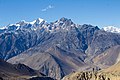
Tsar Tse is a 6,398-metre (20,991-foot) glaciated summit in the Nepalese Himalayas. It is situated 12 kilometres (7.5 mi) northwest of Jomsom in Gandaki Province and the Annapurna Conservation Area. Precipitation runoff from the mountain's slopes drains into tributaries of the Kali Gandaki. Topographic relief is significant as the summit rises 2,400 m (7,870 ft) along the south slope in 3.5 kilometres (2.2 mi), and the north slope rises 2,800 m (9,190 ft) in five kilometres (3.1 mi). The first ascent of the summit was made on September 25, 2018, via the southwest face by Koki Ikeda, Daisuke Shimozuru, Yujiro Suga, and Asahi Takeshita of Japan, with Dendi Sherpa, Ngima Sherpa, Penba Sherpa, Tenjin Sherpa, and Bir Kaji Tamang of Nepal. [4]
Climate
Based on the Köppen climate classification, Tsar Tse is located in a tundra climate zone with cold, snowy winters, and cool summers. [5] Weather systems are forced upwards by the Himalaya mountains (orographic lift), causing heavy precipitation in the form of rainfall and snowfall. Mid-June through early-August is the monsoon season. The months of April, May, September, and October offer the most favorable weather for viewing or climbing this peak. [6]
This page is based on this
Wikipedia article Text is available under the
CC BY-SA 4.0 license; additional terms may apply.
Images, videos and audio are available under their respective licenses.