Affirmative action refers to a set of policies and practices within a government or organization seeking to benefit marginalized groups. Historically and internationally, support for affirmative action has been justified by the idea that it may help with bridging inequalities in employment and pay, increasing access to education, and promoting diversity, social equity, and social inclusion and redressing alleged wrongs, harms, or hindrances, also called substantive equality.

Gaborone is the capital and largest city of Botswana with a population of 246,325 based on the 2022 census, about 10% of the total population of Botswana. Its agglomeration is home to 421,907 inhabitants at the 2011 census. Gaborone has per capita income of US$32,000 (PPP), the highest in Africa.
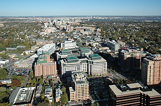
Arlington County, or simply Arlington, is a county in the U.S. state of Virginia. The county is located in Northern Virginia on the southwestern bank of the Potomac River directly across from Washington, D.C., the national capital.
Point Hope is a city in North Slope Borough, Alaska, United States. At the 2010 census the population was 674, down from 757 in 2000. In the 2020 Census, the population rose to 830.
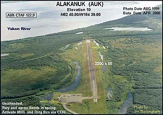
Alakanuk(ah-LUG-uh-nuck) is a second class city in the Kusilvak Census Area of the Unorganized Borough in the western part of the U.S. state of Alaska. As of the 2010 census, the population of the city was 677, up from 652 in 2000.

Eastport is a hamlet and census-designated place (CDP) in Suffolk County, New York, on the South Shore of Long Island. The population was 1,831 at the 2010 census.

Zoar is a village in Tuscarawas County, Ohio, United States. The population was 172 at the 2020 census. The community was founded in 1817 by Radical Pietists as a utopian Christian community, which survived until 1898.

The administrative divisions of New York are the various units of government that provide local services in the American state of New York. The state is divided into boroughs, counties, cities, towns, and villages. They are municipal corporations, chartered (created) by the New York State Legislature, as under the New York State Constitution the only body that can create governmental units is the state. All of them have their own governments, sometimes with no paid employees, that provide local services. Centers of population that are not incorporated and have no government or local services are designated hamlets. Whether a municipality is defined as a borough, city, town, or village is determined not by population or land area, but rather on the form of government selected by the residents and approved by the New York State Legislature. Each type of local government is granted specific home rule powers by the New York State Constitution. There are still occasional changes as a village becomes a city, or a village dissolves, each of which requires legislative action. New York also has various corporate entities that provide local services and have their own administrative structures (governments), such as school and fire districts. These are not found in all counties.
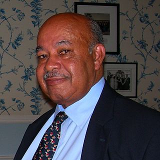
Wardell Anthony "Ward" Connerly is an American political and anti-affirmative action activist, businessman, and former University of California Regent (1993–2005). He is also the founder and the chairman of the American Civil Rights Institute, a national non-profit organization in opposition to racial and gender preferences, and is the president of Californians for Equal Rights, a non-profit organization active in the state of California with a similar mission. He is considered to be the man behind California's Proposition 209 prohibiting race- and gender-based preferences in state hiring, contracting and state university admissions, a program known as affirmative action.
Wingecarribee Shire is the local government area of the Southern Highlands in the state of New South Wales, Australia. The Wingecarribee Shire is around 110 kilometres (70 mi) southwest of Sydney and is part of regional Capital Country and to some extent can be considered part of the Southern Tablelands.

Port Stephens Council is a local government area in the Hunter Region of New South Wales, Australia. The area is just north of Newcastle and is adjacent to the Pacific Highway which runs through Raymond Terrace, the largest town and Council seat. The area is named after Port Stephens, which is the major geographical feature of the area. It extends generally from the Hunter River in the south, to near Clarence Town in the north, and from the Tasman Sea in the east, to just south of Paterson in the west. The mayor of Port Stephens Council is Ryan Palmer. Palmer was caught in a major scandal in 2022 following the purchase of an $86,000 Ford Ranger for mayoral and personal use. Port Stephens is about two and a half hours north of Sydney.
Robelela is a village in Central District of Botswana. It is located south-east of Francistown, close to the border with Zimbabwe. The population was 471 in 2001 census.
Bokaa is a village in Kgatleng District of Botswana. The village is located around 20 km south-west of Mochudi and the population was 5,765 in 2011 census. The village is just north of the Bokaa Dam.
Housing in India varies from palaces of erstwhile maharajas to modern apartment buildings in big cities to tiny huts in far-flung villages. The Human Rights Measurement Initiative finds that India is doing 60.9% of what should be possible at its level of income for the right to housing.
Tsetsebjwe is a village in the Bobirwa sub-district of the Central District of Botswana. It is in the Central Bobonong census district. As of 2001 it had a population of 4,396. The village is northwest of the privately owned Limpopo-Lipadi Game and Wilderness Reserve, near the South African border.
The Thune Dam is a dam on the Thune River in Botswana that was under construction in 2012. It has a planned capacity of 90,000,000 cubic metres (3.2×10⁹ cu ft).
The Dikgatlhong Dam is a dam near the village of Robelela on the Shashe River in Botswana, completed in December 2011. When full it will hold 400,000,000 cubic metres (1.4×10¹⁰ cu ft). The next largest dam in Botswana, the Gaborone Dam, has capacity of 141,000,000 cubic metres (5.0×10⁹ cu ft).
Patayamatebele is a village in the North East District of Botswana near to the Dikgatlhong Dam.
Matopi is a village in the North East District of Botswana near to the Dikgatlhong Dam.
Matsiloje is a village in the North East District of Botswana on the west bank of the Ramokgwebana River, which forms the border with Zimbabwe.
