
Ku-ring-gai Council is a local government area in Northern Sydney, in the state of New South Wales, Australia. The area is named after the Guringai Aboriginal people who were thought to be the traditional owners of the area. More contemporary research suggests that this was not the case.

Wyong Shire was a local government area located in the Central Coast region of New South Wales, Australia. The incorporation of the Wyong area dates back to 7 March 1906 when the entire area of the Brisbane Water Police District outside of the Town of Gosford was proclaimed as the Erina Shire. From 1 January 1947, local government in the Central Coast region was reorganised, creating Gosford Shire and Wyong Shire, which comprised Erina Shire north and east of Kulnura, Central Mangrove and Lisarow.

The City of Willoughby is a local government area on the Lower North Shore of Northern Sydney, in the state of New South Wales, Australia. It is located 6 kilometres (3.7 mi) north of the Sydney central business district. It was first proclaimed in October 1865 as the Municipality of North Willoughby.
The City of Holroyd was a local government area in the western suburbs of Sydney, in the state of New South Wales, Australia. First proclaimed in July 1872 as the "Municipal District of Prospect and Sherwood", it became the "Municipality of Prospect and Sherwood" from 1906 and in 1927 it was renamed the "Municipality of Holroyd" after Arthur Holroyd, the first mayor. From 1 January 1991, city status was granted, becoming the Holroyd City Council. The administrative centre of the City was located in the suburb of Merrylands, located approximately 25 kilometres (16 mi) west of the Sydney central business district.
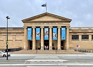
The Art Gallery of New South Wales (AGNSW), founded as the New South Wales Academy of Art in 1872 and known as the National Art Gallery of New South Wales between 1883 and 1958, is located in The Domain, Sydney, Australia. It is the most important public gallery in Sydney and one of the largest in Australia.

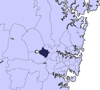
The Auburn City Council was a local government area in the Greater Western Sydney region of New South Wales, Australia. Prior to its 2016 merger, the council area was located about 15 kilometres (9.3 mi) west of the Sydney central business district and had a culturally diverse population. Notable features in the area included the Gallipoli Mosque, located in the suburb of Auburn. The suburb of Sydney Olympic Park, the site of the main venues of the 2000 Summer Olympics, was located in the council area.
The City of Bankstown was a local government area in the south-west region of Sydney, Australia, centred on the suburb of Bankstown, from 1895 to 2016. The last Mayor of the City of Bankstown Council was Clr Khal Asfour, a member of the Labor Party.

The City of Canterbury was a local government area in the south–west region of Sydney, New South Wales, Australia. The city was primarily residential and light industrial in character, and was home to over 130 nationalities. With a majority of its residents being born overseas, the council marketed itself as the "City of Cultural Diversity." First incorporated as the Municipality of Canterbury in 1879, the council became known as the City of Canterbury in 1993.

The Lane Cove Council is a local government area located on the Lower North Shore of Sydney, New South Wales, Australia. The administrative seat of Lane Cove is located 10 kilometres (6.2 mi) north-west of the Sydney central business district.

North Sydney Council is a local government area on the Lower North Shore of Sydney, New South Wales, Australia, established on 29 July 1890 through the amalgamation of three boroughs.

The City of Randwick is a local government area in the eastern suburbs of Sydney, New South Wales, Australia. Established in 1859, Randwick is the second-oldest local government area in New South Wales, after the City of Sydney. It comprises an area of 36 square kilometres (14 sq mi) and as at the 2016 census had a population of 140,660.

The City of Ryde is a local government area in the Northern Sydney region, in the state of New South Wales, Australia. It was first established as the Municipal District of Ryde in 1870, became a municipality in 1906 and was proclaimed as the City of Ryde in 1992.

Waverley Council is a Local government area in the eastern suburbs of Sydney, in the state of New South Wales, Australia. First incorporated on 16 June 1859 as the Municipality of Waverley, it is one of the oldest-surviving local government areas in New South Wales. Waverley is bounded by the Tasman Sea to the east, the Municipality of Woollahra to the north, and the City of Randwick in the south and west. The administrative centre of Waverley Council is located on Bondi Road in Bondi Junction in the Council Chambers on the corner of Waverley Park.

Wombat is a town in South West Slopes region of New South Wales, Australia. It is situated on the Olympic Highway, 15 kilometres (9.3 mi) south-west of the regional centre of Young. It is in the local government area of Hilltops Council.

Abermain is a town 8 km ENE of Cessnock and 3 km west of Weston, in New South Wales, Australia. Abermain is adjacent to Werakata National Park.

Girilambone is a small village in western New South Wales, Australia. It is located north of Nyngan and 666 km north-west of Sydney, on the traditional land of the Wangaibon people. It took its name from an Aboriginal word meaning 'place of many stars'.
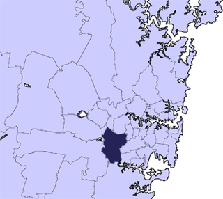
Cumberland Council, trading as Cumberland City Council, is a local government area located in the western suburbs of Sydney in the state of New South Wales, Australia. The Council was formed on 12 May 2016 from the merger of parts of the Cities of Auburn, Parramatta, and Holroyd.

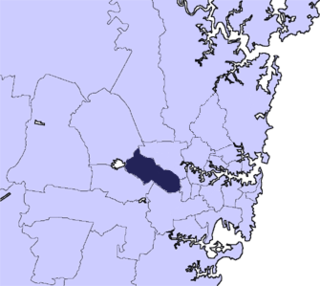
The City of Canterbury Bankstown is a local government area located in the South Western region of Sydney, New South Wales, Australia. The council was formed on 12 May 2016 from a merger of the City of Canterbury and the City of Bankstown, after a review of local government in New South Wales by the state government.

The Central Coast Council is a local government area serving the Lower Hunter area and the Central Coast region of New South Wales, Australia, established on 12 May 2016 following the amalgamation of Gosford City and Wyong Shire councils.

Bayside Council is a local government in New South Wales, Australia. It is located in Sydney, around part of Botany Bay, 7 kilometres (4.3 mi) to 12 kilometres (7.5 mi) south of the CBD. It includes suburbs of South Sydney and the St George area separated by the Cooks River. It comprises an area of 50 square kilometres (19 sq mi) and as at the 2016 census had a population of 156,058.
