
Ecuador, officially the Republic of Ecuador, is a country in northwestern South America, bordered by Colombia on the north, Peru on the east and south, and the Pacific Ocean on the west. Ecuador also includes the Galápagos Islands in the Pacific, about 1,000 kilometers (621 mi) west of the mainland. The country's capital is Quito, but its largest city is Guayaquil.
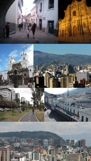
Quito, officially San Francisco de Quito, is the capital of Ecuador, with an estimated population of 2.8 million in its metropolitan area. It is also the capital of the province of Pichincha. Quito is located in a valley on the eastern slopes of Pichincha, an active stratovolcano in the Andes.

The Pan-American Highway is a network of roads stretching across the Americas, measuring about 30,000 kilometres (19,000 mi) in total length. Except for a break of approximately 100 km (60 mi) across the border between Colombia and Panama, the roads link most of the Pacific coastal countries of North America and South America in a connected highway system. According to Guinness World Records, the Pan-American Highway is the world's longest "motorable road".

The Inca road system was the most extensive and advanced transportation system in pre-Columbian South America. It was about 40,000 kilometres (25,000 mi) long. The construction of the roads required a large expenditure of time and effort.

Cuenca, officially Santa Ana de los Ríos de Cuenca, is an Ecuadorian city, head of the canton of the same name and capital of the province of Azuay, as well as its largest and most populated city. It is crossed by the Tomebamba, Tarqui, Yanuncay and Machángara rivers, in the south-central inter-Andean region of Ecuador, in the Paute river basin, at an altitude of 2,538 meters above sea level and with a temperate Andean climate averaging 16.3 °C.

Carchi is a province in Ecuador. The capital is Tulcán. The Carchi River rises on the slopes of Chiles volcano and forms the boundary between Colombia and Ecuador near Tulcan. Rumichaca Bridge is the most important land route between Colombia and Ecuador.

Sucumbíos is a province in northeast Ecuador. The capital and largest city is Nueva Loja. It is the fifth largest province in the country, with an area of 18,084 km2. In 2010, it had a population of 176,472 inhabitants.

Riobamba is the capital of Chimborazo Province in central Ecuador, and is located in the Chambo River Valley of the Andes. It is located 200 km (120 mi) south of Ecuador's capital Quito and situated at an elevation of 2,754 m.

Ipiales is a city and Catholic bishopric in Nariño Department, southern Colombia, near the border with Ecuador. It is located at around 0°49′49″N77°38′40″W, with an elevation of about 2950 m. Ipiales is located on the high plateau called "Tuquerres e Ipiales," the city lies at a distance of 82 km from Pasto, the department's capital." Ipiales is known as "la ciudad de las nubes verdes" because sometimes, especially in the afternoon, greenish clouds appear over the city. One of the area's favorite foods is the guinea pig or cavy, called kuy or kuwi. The economy of this city is based on border trade between Ecuador and Colombia.

The Ecuadorian–Colombian War was a series of armed conflicts waged between the current republics of Colombia and Ecuador between 1862 and 1863.
The following outline is provided as an overview of and topical guide to Ecuador:

Puyo, also known as El Puyo, is the capital of Pastaza, a province in Ecuador. Puyo is located at an altitude of approximately 950 metres above sea level by the Puyo River, a tributary of the Pastaza River, which eventually leads into the Amazon River. True to its name, derived from the Kichwa word for "cloudy", the local climate is a wet one and the weather is often overcast.

TAME Flight 120 was a Boeing 727-134 airliner, registration HC-BLF, named El Oro, operating as a scheduled international passenger flight between Quito, Ecuador and Cali, Colombia, with a scheduled stopover at the Ecuadorian border town of Tulcán. The aircraft crashed while on approach to Tulcán's Teniente Coronel Luis A. Mantilla International Airport on January 28, 2002. The pilot flew the approach incorrectly in reportedly foggy conditions, and the aircraft crashed into the side of the Cumbal Volcano, located near Ipiales, Colombia, at 10:23 in the morning. All 94 passengers and crew were killed in the crash.

The Carchi River is a river of Ecuador. It rises on the slopes of Chiles Volcano, elevation 4,698 metres (15,413 ft), on the border of Ecuador and Colombia. The river flows eastward across the high plateau of El Angel. The Carchi has a total course of about 45 kilometres (28 mi), forming the border between Colombia and Ecuador for about 20 kilometres (12 mi). It passes between the cities of Tulcan, Ecuador and Ipiales, Colombia and beneath the Rumichaca Bridge, the principal terrestrial link between Colombia and Ecuador. Entering Colombia, the Carchi becomes known as the Guáitara River which is a tributary of the Patía River.

Tulcán Canton is a canton of Ecuador, located in Carchi Province. Its capital is the city of Tulcán. The population of the canton in the 2001 census was 77,175 and 86,498 in the 2010 census. The area of the canton is 1,812 square kilometres (700 sq mi).

The Rumichaca Bridge is the principal highway passage between Colombia and Ecuador. The bridge is located 3 kilometres (1.9 mi) from the city of Ipiales, Colombia and 7 kilometres (4.3 mi) from the city of Tulcán, Ecuador. The bridge is located in the Andes at an elevation of 2,763 metres (9,065 ft). The Pan-American Highway crosses the bridge.

El Ángel is a town located in the northern Andes of Ecuador, capital of the Espejo canton in the Carchi province.

Ecuador is a nation in northwest South America known as the Republic of Ecuador. Hundreds of thousands of kinds of plants and animals can be found there as a result of the diversity of its four zones. There are roughly 1640 bird species there. Along with the 4,500 kinds of butterflies, there are also 345 reptiles, 358 amphibians, and 258 mammals. Ecuador is regarded as one of the 17 nations with the highest concentration of biodiversity on Earth. The majority of its animals and plants are found in 26 state-protected areas. It also provides gastronomy, a range of cultures and customs, and historical attractions like Quito.
The Inca-Caranqui archaeological site is located in the village of Caranqui on the southern outskirts of the city of Ibarra, Ecuador. The ruin is located in a fertile valley at an elevation of 2,299 metres (7,543 ft). The region around Caranqui, extending into the present day country of Colombia, was the northernmost outpost of the Inca Empire and the last to be added to the empire before the Spanish conquest of 1533. The archaeological region is also called the Pais Caranqui.

The Free Province of Guayaquil was a South American state that emerged between 1820 and 1822 with the independence of the province of Guayaquil from the Spanish monarchy. The free province had a provisional government and constitution until its annexation by Gran Colombia in 1822. Its successor was the Department of Guayaquil forming part of Gran Colombia.
The Spanish province of Guayaquil had been separated from the Viceroyalty of Peru and in those days it only depended legally on the court of the Real Audiencia de Quito. About a decade later, the Departments of Guayaquil, Azuay, and Ecuador separated from Gran Colombia forming the current Ecuador.


