Latacunga

Last updated • 3 min readFrom Wikipedia, The Free Encyclopedia
Latacunga
City
San Vicente Mártir de Latacunga
Collage Latacunga.png
From top, left to right: Central Park Vicente León, Saint Joseph Cathedral, City hall of Latacunga, the House of the Marquises, Chile Square, Vicente León High School, Our Lady of Mercy Church, Cotopaxi Technical University and Salcedo Street.
BanderaLatacunga.svg
Nickname: 
Mashca City (Ciudad Mashca)
Ecuador location map.svg
Red pog.svg
Latacunga
Latacunga's location in Ecuador
Coordinates: 0°55′54.98″S78°36′57.88″W / 0.9319389°S 78.6160778°W / -0.9319389; -78.6160778
Country Flag of Ecuador.svg  Ecuador
Province Bandera Provincia Cotopaxi.svg  Cotopaxi
Canton Latacunga
FoundedApril 12, 1557
Founded byAntonio de Clavijo
Named for Llacta Cunani
Parishes
Urban Parishes
  • La Matriz
  • Eloy ALfaro
  • Ignacio Flores
  • San Buenaventura
  • Juan Montalvo
  • Gil Ramírez Dávalos
  • Hermano Miguel
Government
  MayorFabricio Tinajero
Area
  City19.99 km2 (7.72 sq mi)
Elevation
2,860 m (9,380 ft)
Population
 (2022 census) [1]
  City77,267
  Density3,900/km2 (10,000/sq mi)
Demonym Latacungueño / a
Time zone UTC-5 (ECT)
ZIP codes
Zip codes
Area code (+593) 3
Website Official website (in Spanish)
Monument to Vicente Leon on the main square of Latacunga Latacunga Vicente Leon.jpg
Monument to Vicente León on the main square of Latacunga

Latacunga (Spanish pronunciation: [lataˈkuŋɡa] ; Quechua: Latakunga) is a plateau city of Ecuador, capital of the Cotopaxi Province, 89 km (55 mi) south of Quito, near the confluence of the Alaquez and Cutuchi rivers to form the Patate, the headstream of the Pastaza. At the time of census 2022 Latacunga had a population of 77,267 [1] largely mestizo and indigenous.

Contents

Latacunga took its independence from Spain on November 11, 1820. [2]

Latacunga is an hour and half south from Quito on the Pan-American Highway. It was previously also on the old road from Quito to Guayaquil, and has a railway station between those cities. It is 9, 383. 2  ft (2,860 m). above sea level. Its climate is cold and windy, due to the neighboring snowclad heights, and the barren, pumice-covered tableland on which it stands. The active volcano Cotopaxi is only 25 kilometres (16 mi) away, and the town has suffered repeatedly from eruptions. Founded in 1534, it was four times destroyed by earthquakes between 1698 and 1798. The neighboring ruins of an older native town are said to date from the Incas Empire.

Latacunga's most noted food is chugchucaras, empanadas, plantains, popcorn, and tostado (a type of toasted corn). Often, food is mixed with ají, a type of condiment that can be mild to very spicy depending on its preparation.

The Latacunga economy is dependent on agriculture, floriculture and commerce. It has an international airport, the Cotopaxi International Airport, that is not used for international passenger use, but as an Air Force base and some special commercial flights. The local volcanic activity has led to the accumulation of pumice deposits which are currently mined, as well as the presence of natural sparkling water, which is bottled under the brand name San Felipe.

The airplane scene in the film Maria Full of Grace was filmed out of the Latacunga airport using local extras. The landscape seen from the plane is the area surrounding Latacunga.

Traditional festivals

Parade in Latacunga city Comparsa latacunguena desfilando.jpg
Parade in Latacunga city

La Fiesta de la Mama Negra is a well-known traditional festival in Latacunga. [3] It takes place twice a year, and originates from a mixture of indigenous, Spanish and African influences. The first one was organized in September by the people from the markets "La Merced y Del Salto" in honor of the Virgin of Mercy, Virgen de la Merced. The Virgin is venerated because she allegedly stopped the Cotopaxi Volcano eruption in 1742. Inhabitants of Latacunga call her Abogada y patrona del volcan, meaning "advocate and patron of the volcano".

The second celebration is a party which Latacunga's inhabitants celebrate every year on Ecuador's Independence Day. It is a parade with the participation of well-known people, the army, clergy and others. [4]

Both of these fiestas include a lengthy parade of various cultural characters, all dressed-up in various colors. The 'mama negra' is the last person to pass through, which is the culmination of each parade. It is a person with their face painted in black, riding a horse, and spraying the crowd with milk. Homemade strong alcoholic drinks are freely passed between one another along the parade route, which can be quite chaotic, closing the road at times and making the route impassable.

Historic downtown

Latacunga's historic downtown extends about 30 squares. Prominent buildings to visit are:

Climate

Latacunga features an Oceanic climate (Cfb) under Köppen climate classification.

Climate data for Latacunga, elevation 2,785 m (9,137 ft), (1971–2000)
MonthJanFebMarAprMayJunJulAugSepOctNovDecYear
Mean daily maximum °C (°F)20.3
(68.5)
19.9
(67.8)
19.2
(66.6)
19.2
(66.6)
19.0
(66.2)
18.0
(64.4)
18.0
(64.4)
18.4
(65.1)
19.1
(66.4)
20.0
(68.0)
20.5
(68.9)
20.4
(68.7)
19.3
(66.8)
Mean daily minimum °C (°F)7.9
(46.2)
7.2
(45.0)
8.2
(46.8)
8.5
(47.3)
8.2
(46.8)
7.3
(45.1)
7.1
(44.8)
6.5
(43.7)
6.7
(44.1)
7.2
(45.0)
7.2
(45.0)
7.5
(45.5)
7.5
(45.4)
Average precipitation mm (inches)30.0
(1.18)
53.0
(2.09)
54.0
(2.13)
66.0
(2.60)
40.0
(1.57)
28.0
(1.10)
15.0
(0.59)
15.0
(0.59)
25.0
(0.98)
55.0
(2.17)
52.0
(2.05)
42.0
(1.65)
475
(18.7)
Average relative humidity (%)72737677767776747373727074
Source: FAO [6]

Universities

Sports

Club Deportivo Universidad Tecnica de Cotopaxi, is a soccer team of Latacunga City.

Sociedad Deportiva Flamengo is the city's football (soccer) club. They play their home games at Estadio La Cocha.

Transport

Cotopaxi International Airport

Notes

    Related Research Articles

    <span class="mw-page-title-main">Geography of Ecuador</span>

    Ecuador is a country in western South America, bordering the Pacific Ocean at the Equator, for which the country is named. Ecuador encompasses a wide range of natural formations and climates, from the desert-like southern coast to the snowcapped peaks of the Andes mountain range to the plains of the Amazon Basin. Cotopaxi in Ecuador is one of the world's highest active volcanos. It also has a large series of rivers that follow the southern border and spill into the northwest area of Peru.

    <span class="mw-page-title-main">Quito</span> Capital city in Pichincha, Ecuador

    Quito, officially San Francisco de Quito, is the capital of Ecuador, with an estimated population of 2.8 million in its metropolitan area. It is also the capital of the province of Pichincha. Quito is located in a valley on the eastern slopes of Pichincha, an active stratovolcano in the Andes.

    <span class="mw-page-title-main">Chimborazo</span> Volcano and highest mountain in Ecuador

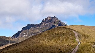
    Chimborazo is an inactive stratovolcano situated in Ecuador in the Cordillera Occidental range of the Andes. Its last known eruption is believed to have occurred around 550 A.D. Although not the tallest mountain in the Andes or on Earth relative to sea level, its summit is the farthest point on Earth's surface from the Earth's center due to its location along the planet's equatorial bulge. Chimborazo's height from sea level is 6,263 m (20,548 ft), well below that of Mount Everest.

    <span class="mw-page-title-main">Cotopaxi</span> Active stratovolcano in Ecuador

    Cotopaxi is an active stratovolcano in the Andes Mountains, located near Latacunga city of Cotopaxi Province, about 50 km (31 mi) south of Quito, and 31 km (19 mi) northeast of the city of Latacunga, Ecuador. It is the second highest summit in Ecuador, reaching a height of 5,897 m (19,347 ft). Cotopaxi is among the highest active volcanoes in the world.

    <span class="mw-page-title-main">Pichincha (volcano)</span> Volcano in north-central Ecuador

    Pichincha is a stratovolcano in Ecuador. The capital Quito wraps around its eastern slopes.

    <span class="mw-page-title-main">Cotopaxi Province</span> Province of Ecuador

    Cotopaxi is one of the provinces of Ecuador. The capital is Latacunga. The province contains the Cotopaxi Volcano, an intermittent volcano with a height of 19,347 feet (5,897 m).

    <span class="mw-page-title-main">Ibarra, Ecuador</span> City in Imbabura, Ecuador

    Ibarra is a city in northern Ecuador and the capital of the Imbabura Province. It lies at the foot of the Imbabura Volcano and on the left bank of the Tahuando river. It is located about 70 kilometres (43 mi) northeast of Ecuador's capital Quito.

    <span class="mw-page-title-main">Riobamba</span> City in Chimborazo, Ecuador

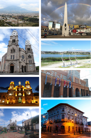
    Riobamba is the capital of Chimborazo Province in central Ecuador, and is located in the Chambo River Valley of the Andes. It is located 200 km (120 mi) south of Ecuador's capital Quito and situated at an elevation of 2,754 m.

    <span class="mw-page-title-main">Portoviejo</span> City in Manabí, Ecuador

    Portoviejo, also known as San Gregorio de Portoviejo, is a city in Ecuador, and the capital of the Province of Manabí 30 km (19 mi) from the Pacific coast. It is still known as the city of the "Royal Tamarind Trees" due to former Tamarind plantations in the area.

    <span class="mw-page-title-main">Battle of Pichincha</span> Battle of the Ecuadorian War of Independence

    The Battle of Pichincha took place on 24 May 1822, on the slopes of the Pichincha volcano, 3,500 meters above sea-level, right next to the city of Quito, in modern Ecuador.

    <span class="mw-page-title-main">Ecuadorian War of Independence</span> 1809–1822 armed conflict in Ecuador

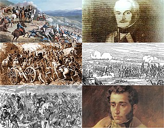
    The Ecuadorian War of Independence, part of the Spanish American wars of independence of the early 19th century, was fought from 1809 to 1822 between Spain and several South American armies over control of the Real Audiencia of Quito, a Spanish colonial jurisdiction which later became the modern Republic of Ecuador. The war ended with the defeat of the Spanish forces at the Battle of Pichincha on May 24, 1822, which brought about the independence of all the lands of the Real Audiencia of Quito.

    <span class="mw-page-title-main">Cotopaxi International Airport</span> Airport in Ecuador

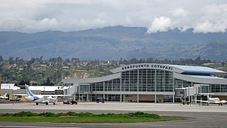
    Cotopaxi International Airport is a high-elevation airport in Latacunga, the capital of the Cotopaxi Province in Ecuador. The airport is within a broad valley of the Ecuadoran Andes, with rising terrain east and west, and mountainous terrain distant in all quadrants.

    The National Polytechnic School, also known as EPN, is a public university in Quito, Ecuador. The campus, named after José Rubén Orellana, is located in the east-central part of Quito. It occupies an area of 15.2 hectares and has a built area of around 62,000 metres2. Its student body numbers approximately 10,000, of which thirty percent are women. The main campus encompasses ten teaching and research faculties, in addition to four technical and specialized institutes. EPN was founded in 1869 with the aim of becoming the first technical and technological center in the country. Since its beginnings, EPN adopted the polytechnic university model, which stresses laboratory instruction in applied science and engineering. At the campus, there are some libraries with content primarily oriented to engineering and scientific topics.

    <span class="mw-page-title-main">Cotopaxi National Park</span> Protected area in Ecuador

    Cotopaxi National Park is a protected area in Ecuador situated in the Cotopaxi, Napo and Pichincha provinces, roughly 50 km (31 mi) south of Quito. The Cotopaxi volcano that lends its name to the park is located within its boundaries, together with two others: the dormant Rumiñawi volcano to its north-west and the historical Sincholagua volcano to the south-east. Cotopaxi is among the highest active volcanoes in the world. Its most recent eruption began on 14 August 2015, and ended on 24 January 2016.

    Píntag is an agrarian village located 27.5 kilometers southeast of Quito in Pichincha Province, Ecuador.

    The Directorate of the Aeronautics Industry (DIAF) is a company affiliated to the Ecuadorian Air Force General Command, specializing in aircraft maintenance services, electronic maintenance, research and modernization of civil and military aircraft to Ecuador and Latin America. Since its establishment on 15 June 1992, thanks to its efficient work, it is one of the biggest companies within the field in the country, thus represents a significant contribution to the development of domestic aviation market.

    <span class="mw-page-title-main">Sincholagua Volcano</span>

    Sincholagua is an inactive volcano located in Ecuador 17 km (11 mi) northeast of Cotopaxi Volcano and 45 km (28 mi) southeast of Quito. It is the 12th highest peak in the country at 4,899 m (16,073 ft) but also one of the lesser known ones. The name of the mountain comes from the indigenous language Quichua and means "strong above". Due to its close proximity to Cotopaxi, the second highest peak in Ecuador and the most popular volcano, it is far less frequently visited compared to other mountains in the country. It has a sharp peak and at one point had glacial cover year round, but all of the glaciers melted a few decades ago. However, snow can still be seen on the peak since there is sometimes heavy snowfall at the summit.

    <span class="mw-page-title-main">Tourism in Ecuador</span>

    Ecuador is a nation in northwest South America known as the Republic of Ecuador. Hundreds of thousands of kinds of plants and animals can be found there as a result of the diversity of its four zones. There are roughly 1640 bird species there. Along with the 4,500 kinds of butterflies, there are also 345 reptiles, 358 amphibians, and 258 mammals. Ecuador is regarded as one of the 17 nations with the highest concentration of biodiversity on Earth. The majority of its animals and plants are found in 26 state-protected areas. It also provides gastronomy, a range of cultures and customs, and historical attractions like Quito.

    <span class="mw-page-title-main">Mama Negra</span> Traditional festival

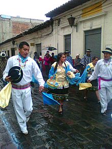
    The Mama Negra is a traditional festival held twice a year in Latacunga, Cotopaxi Province, Ecuador. Also called La Santísima Tragedia, it is a celebration in honor of the Virgen de la Merced, who is said to have stopped an eruption of Cotopaxi volcano in 1742. The festival is also a celebration of the anniversary the city of Latacunga's independence.

    From January 31 to February 1, 2022, heavy rainfall impacted Ecuador, which caused multiple landslides, floods, and mudflows. It was caused by the country's biggest rainfall in nearly 20 years, which fell on the capital.

    References

    1. 1 2 Citypopulation.de Population and area of Latacunga
    2. "La Independencia de Latacunga el 11 de noviembre de 1820". Archived from the original on 2014-05-29. Retrieved 2014-05-29.
    3. "Fiesta de la Mama Negra".
    4. "Información General de Latacunga" . Retrieved 2007-10-22.
    5. "LATACUNGA. Sus Atractivos Turísticos". Archived from the original on 2007-10-11. Retrieved 2007-10-22.
    6. "CLIMWAT climatic database". Food and Agriculture Organization of United Nations. Retrieved 20 June 2024.

    Wikisource-logo.svg This article incorporates text from a publication now in the public domain :  Chisholm, Hugh, ed. (1911). "Latacunga". Encyclopædia Britannica . Vol. 16 (11th ed.). Cambridge University Press. p. 239.