
Cotopaxi is an active stratovolcano in the Andes Mountains, located in Latacunga city of Cotopaxi Province, about 50 km (31 mi) south of Quito, and 31 km (19 mi) northeast of the city of Latacunga, Ecuador. It is the second highest summit in Ecuador, reaching a height of 5,897 m (19,347 ft). Cotopaxi is among the highest active volcanoes in the world.
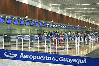
José Joaquín de Olmedo International Airport is an international airport serving Guayaquil, the capital of the Guayas Province and the second most populous city in Ecuador. It is the second busiest airport in Ecuador.

Cotopaxi is one of the provinces of Ecuador. The capital is Latacunga. The province contains the Cotopaxi Volcano, an intermittent volcano with a height of 19,347 feet (5,897 m).

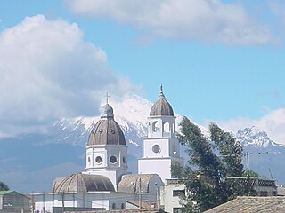
Latacunga is a plateau city of Ecuador, capital of the Cotopaxi Province, 89 km (55 mi) south of Quito, near the confluence of the Alaquez and Cutuchi rivers to form the Patate, the headstream of the Pastaza. At the time of census 2010 Latacunga had 98,355 inhabitants, largely mestizo and indigenous.

Ann Arbor Municipal Airport is a general aviation airport in Washtenaw County, Michigan, United States. It is included in the Federal Aviation Administration (FAA) National Plan of Integrated Airport Systems for 2017 to 2021, in which it is categorized as a regional general aviation facility.
Cargo B Airlines was a cargo airline with its head office in the Brucargo Building 706 in Zaventem, Belgium.
Lawrence County Airpark is a public use airport located two nautical miles (3.7 km) west of the central business district of Chesapeake, a village in Lawrence County, Ohio, United States. It is publicly owned by Lawrence County Board of Commissioners. The airport lies across the Ohio River from Huntington, West Virginia.
Poplar Grove Airport is a small general aviation airport located in Poplar Grove, Illinois, United States. The airport was founded in 1972 as Belvidere Airport and renamed in 1994. It is located 3 miles south of Poplar Grove, and 3 miles north of Belvidere. The airport is privately owned and open to the public.

Mariscal Lamar International Airport is a high elevation airport serving Cuenca, the capital of the Azuay Province in Ecuador. It is named after the Peruvian military leader and politician José de la Mar, a native of Cuenca.

A Conviasa Boeing 737-291 Advanced ferry flight from Maiquetia, Venezuela to Latacunga, Ecuador crashed into Illiniza Volcano. The aircraft had been stored at Caracas and was being ferried to a new owner. There were three crew on board with no passengers. There were no survivors.
White Cloud Airport is a public airport owned and operated by the City of White Cloud located 1m (1.6 km) north of White Cloud, a city in Newaygo County, Michigan, United States. The airport is uncontrolled, and is used for general aviation purposes. It is included in the Federal Aviation Administration (FAA) National Plan of Integrated Airport Systems for 2017–2021, in which it is categorized as a basic general aviation facility. .The airport covers an area of 72 acres (29 ha).
The Directorate of the Aeronautics Industry (DIAF) is a company affiliated to the Ecuadorian Air Force General Command, specializing in aircraft maintenance services, electronic maintenance, research and modernization of civil and military aircraft to Ecuador and Latin America. Since its establishment on 15 June 1992, thanks to its efficient work, it is one of the biggest companies within the field in the country, thus represents a significant contribution to the development of domestic aviation market.
Chachoan Airport is a high elevation airport serving Ambato, capital of the Tungurahua Province in Ecuador. The airport is 6 kilometres (3.7 mi) northeast of Ambato, in a broad basin of the central Andes mountains cut through by the Ambato River.
Paul C. Miller–Sparta Airport is a public airport located 3 mi (5 km) southeast of Sparta, Michigan. Established in 1941, the airport is currently owned and operated by the Village of Sparta and is self-supporting, requiring no public funding. It is included in the Federal Aviation Administration (FAA) National Plan of Integrated Airport Systems for 2017–2021, in which it is categorized as a regional general aviation facility.
Latacunga Canton is one of seven cantons of the Cotopaxi Province in Ecuador. Its population at the 2001 census was 143,979. Its capital is the town of Latacunga.
Jack Barstow Airport, also known as Jack Barstow Municipal Airport, is a city-owned, public-use airport located three nautical miles (6 km) northwest of the central business district of Midland, a city in Midland County, Michigan, United States. It is included in the Federal Aviation Administration (FAA) National Plan of Integrated Airport Systems for 2017–2021, in which it is categorized as a local general aviation facility.
Greenville Municipal Airport is a city-owned, public-use airport located three nautical miles (6 km) south of the central business district of Greenville, a city in Montcalm County, Michigan, United States. It is included in the Federal Aviation Administration (FAA) National Plan of Integrated Airport Systems for 2017–2021, in which it is categorized as a local general aviation facility.

Jumandy Airport is an airport serving Tena, Napo Province, Ecuador. It is 3 kilometres (1.9 mi) west of the village of Ahuano, and about 25 kilometres (16 mi) from Tena. It replaces Tena's Mayor Galo de la Torre Airport, which closed in 2001.

The Mama Negra is a traditional festival held twice a year in Latacunga, Cotopaxi Province, Ecuador. Also called La Santísima Tragedia, it is a celebration in honor of the Virgen de la Merced, who is said to have stopped an eruption of Cotopaxi volcano in 1742. The festival is also a celebration of the anniversary the city of Latacunga's independence.


