
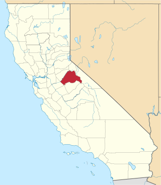
Tuolumne County, officially the County of Tuolumne, is a county located in the U.S. state of California. As of the 2020 census, the population was 55,620. The county seat and only incorporated city is Sonora.
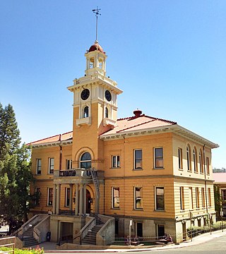
Sonora is the county seat of Tuolumne County, California, United States. Founded during the California Gold Rush by Mexican miners from Sonora, the city population was 5,121 during the 2020 Census, an increase from the 4,903 counted during the 2010 Census.

Tuolumne City is an unincorporated town in Tuolumne County, California. A census-designated place (CDP) officially known as Tuolumne also encompasses the town. The population of the CDP was 1,779 at the 2010 census, down from 1,865 at the 2000 census.

Tuolumne Meadows is a gentle, dome-studded, sub-alpine meadow area along the Tuolumne River in the eastern section of Yosemite National Park in the United States. Its approximate location is 37°52.5′N119°21′W. Its approximate elevation is 8,619 feet (2,627 m). The term Tuolumne Meadows is also often used to describe a large portion of the Yosemite high country around the meadows, especially in context of rock climbing.

Hetch Hetchy is a valley, a reservoir, and a water system in California in the United States. The glacial Hetch Hetchy Valley lies in the northwestern part of Yosemite National Park and is drained by the Tuolumne River. For thousands of years before the arrival of settlers from the United States in the 1850s, the valley was inhabited by Native Americans who practiced subsistence hunting-gathering. During the late 19th century, the valley was renowned for its natural beauty – often compared to that of Yosemite Valley – but also targeted for the development of water supply for irrigation and municipal interests. The controversy over damming Hetch Hetchy became mired in the political issues of the day. The law authorizing the dam passed Congress on December 7, 1913. In 1923, the O'Shaughnessy Dam was completed on the Tuolumne River, flooding the entire valley under the Hetch Hetchy Reservoir. The dam and reservoir are the centerpiece of the Hetch Hetchy Project, which in 1934 began to deliver water 167 miles (269 km) west to San Francisco and its client municipalities in the greater San Francisco Bay Area.

The Tuolumne River flows for 149 miles (240 km) through Central California, from the high Sierra Nevada to join the San Joaquin River in the Central Valley. Originating at over 8,000 feet (2,400 m) above sea level in Yosemite National Park, the Tuolumne drains a rugged watershed of 1,958 square miles (5,070 km2), carving a series of canyons through the western slope of the Sierra. While the upper Tuolumne is a fast-flowing mountain stream, the lower river crosses a broad, fertile and extensively cultivated alluvial plain. Like most other central California rivers, the Tuolumne is dammed multiple times for irrigation and the generation of hydroelectricity.

Mount Lyell is the highest point in Yosemite National Park, at 13,114 feet (3,997 m). It is located at the southeast end of the Cathedral Range, 1+1⁄4 miles northwest of Rodgers Peak. The peak as well as nearby Lyell Canyon is named after Charles Lyell, a well-known 19th century geologist. The peak had one of the last remaining glaciers in Yosemite, Lyell Glacier. The Lyell Glacier is currently considered to be a permanent ice field, not a living glacier. Mount Lyell divides the Tuolumne River watershed to the north, the Merced to the west, and the Rush Creek drainage in the Mono Lake Basin to the southeast.

Area codes 209 and 350 are telephone area codes in the North American Numbering Plan (NANP) for the U.S. state of California. Their service area includes Stockton, Modesto, Turlock, Merced, Winton, Atwater, Livingston, Manteca, Ripon, Tracy, Lodi, Galt, Sonora, Los Banos, San Andreas, Mariposa, and Yosemite, the northern San Joaquin Valley, and the Sierra Foothills.

The West Side Lumber Company railway was the last of the 3 ft narrow-gauge logging railroads operating in the American west.
La Grange is a small unincorporated community in rural Stanislaus County, California. Its altitude is 249 feet (76 m). As of 2020 it has a population of 166. It is located at 37°39′49″N120°27′49″W along the Tuolumne River, and is near the La Grange Dam and the New Don Pedro Dam.
This is a list of the National Register of Historic Places listings in Tuolumne County, California.
Springfield is an unincorporated community located in Tuolumne County, California. It is a former California Gold Rush boomtown in the foothills of the Sierra Nevada, and is now designated as a California Historical Landmark. Springfield is located 1.1 mi SW of Columbia another gold rush boomtown.
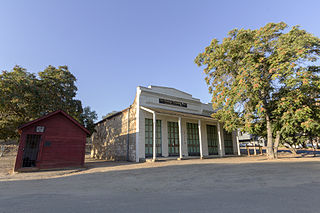
Standard is an unincorporated community in Tuolumne County, California, United States that lies 4 miles (6.4 km) east-southeast of Sonora. Its post office, opened in 1910, is assigned ZIP code 95373. Standard was established as a company town for the Standard Lumber Company. Standard was a station on the former Sierra Railway, now Sierra Northern Railway the depot has survived and is currently in use as a nursery and a grocery (19073). Sierra Pacific Industries operates a mill in Standard.
The Empire City Historic Landmark is a California Historic Landmark in honor of the pioneer John C. Marvin who from 1850, settled on the south bank of the Tuolumne River and called the town "Empire City". Empire City was the head of navigation for small steamboats that could ascend the Tuolumne River carrying passengers and supplies. It was the shipping point for the large grain crops grown in the area. At its height, the town had three stores, a three-story hotel, two boarding houses, a blacksmith shop, a church, and a school house. Empire City was voted as the county seat of Stanislaus County from October 1854 to December 1855. The town was destroyed by flood waters during the Great Flood of 1862. A new railroad town was built 40 years later 1 mile north of the old town site, taking the name Empire.
There are 21 routes assigned to the "E" zone of the California Route Marker Program, which designates county routes in California. The "E" zone includes county highways in Alpine, Amador, Butte, Calaveras, El Dorado, Placer, Plumas, Sacramento, Solano, Tuolumne, Yolo, and Yuba counties.
Strawberry is an unincorporated community and a census-designated place (CDP) in Tuolumne County, California. Strawberry is located on California State Route 108 10 miles (16 km) northeast of Long Barn. Strawberry has a post office with ZIP code 95375, which opened in 1949. Strawberry sits at an elevation of 5,325 feet (1,623 m). The 2010 United States census reported Strawberry's population was 125.
Tuolumne City is a former settlement on the Tuolumne River, originally in Tuolumne County, during the California Gold Rush.
French Flat or French Camp now a ghost town was in Tuolumne County, California. It was located near French Flat from which it took its name, one and a half miles south southwest of Tuttletown. Its location was near the flat, northwest of an 1,894-foot (577 m) mountain.
Sawmill Flat is a locale, formerly a settlement during the California Gold Rush, now a ghost town in Tuolumne County, California. It lies at an elevation of 2,136 feet south of Martinez, another former gold rush settlement.
Second Garrotte is a ghost town located near Groveland in Tuolumne County, California originally settled during the California Gold Rush. The site of Second Garrote is a California Historical Landmark, No. 460 listed on May 9, 1950. It lies at an elevation of 2,894 feet in Second Garrotte Basin.
