
Burton Latimer is a town in North Northamptonshire, England, approximately 3.1 miles (5.0 km) southeast of Kettering and 4.5 miles north of Wellingborough. At the 2021 census, its population was 10,444.
Rothwell is a market town in North Northamptonshire, England. It is close to three larger towns, situated 4 miles [6.4km] northwest of Kettering, 7 miles [11km] southeast of Market Harborough and 8 miles [12.8km] southwest of Corby. Rothwell's nearest railway station is at Kettering on the Midland Main Line.
Scaldwell is a village and civil parish in the West, Northamptonshire, England.
Lamport is a village and civil parish in West Northamptonshire, England. The village is on the A508, about 8 miles (13 km) south of Market Harborough and 8 miles (13 km) north of Northampton. Nearby is Lamport Hall. At the time of the 2001 census, the parish's population was 207 people, including Hanging Houghton and increasing to 225 at the 2011 Census.

Cogenhoe is a village and former civil parish, now in the parish of Cogenhoe and Whiston, in the West Northamptonshire district, in the ceremonial county of Northamptonshire, England. The civil parish of Cogenhoe and Whiston had a population at the 2011 census of 1,436.

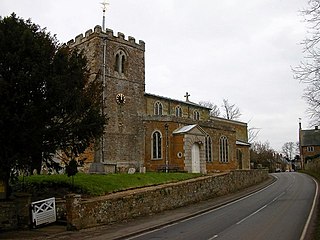
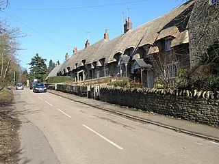
Woodford is a large village and civil parish located in North Northamptonshire, England. At the time of the 2011 census, the parish's population was 1,461 people.

Whiston is a village and former civil parish, now in the parish of Cogenhoe and Whiston, in the West Northamptonshire district, in the ceremonial county of Northamptonshire, England. It is 4 miles due east of the county town of Northampton. In 1931 the parish had a population of 49.
Stowe Nine Churches is a civil parish incorporating the settlements of Church Stowe and Upper Stowe in the West Northamptonshire district, in the ceremonial county of Northamptonshire, England. The population of the parish at the 2011 census was 259.

Finedon is a town and civil parish in North Northamptonshire, England, with a population at the 2021 census of 4,552. In 1086 when the Domesday Book was completed, Finedon was a large royal manor, previously held by Queen Edith, wife of Edward the Confessor.

Ab Kettleby is a village and civil parish in the Melton district of Leicestershire, England, located 3 miles (4.8 km) north of Melton Mowbray, on the A606 road. It had a population of 501 in 2001; at the 2011 census this had increased to 529.

Sproxton is a village and civil parish within the Borough of Melton in Leicestershire, England, close to the border with Lincolnshire. It has approximately 80 occupied dwellings (2021) and a population of 480, rising to 658 at the 2011 census.

Blisworth is a village and civil parish in the West Northamptonshire, England. The West Coast Main Line, from London Euston to Manchester and Scotland, runs alongside the village partly hidden and partly on an embankment. The Grand Union Canal passes through the village and the north portal of the Blisworth tunnel is near Stoke Road.

Islip is a village and civil parish in North Northamptonshire, England. The village is just west of Thrapston and 7 miles (11 km) east of Kettering. The parish is bounded to the east by the River Nene and to the north by Harpurs Brook, a tributary of the Nene. The 2011 Census recorded the parish's population as 829 people.
Thorpe Malsor is a village and civil parish 2 miles (3 km) west of Kettering, Northamptonshire, England. The population at the 2011 Census was 145.

Lowick is a village and civil parish forming part of the district of North Northamptonshire, England, about 2 miles (3.2 km) north-west of Thrapston. It appears in the Domesday Book of 1086 as Luhwik, and later as Lofwyk and in 1167 as Luffewich. The name derives from Old English "Luhha's or Luffa's dwelling place", wic being cognate to vicus in Latin. At the time of the 2011 census, the parish's population was 298 people.
Cranford St John is a village and former civil parish, now in the parish of Cranford, in the North Northamptonshire district, in the ceremonial county of Northamptonshire, England. It is in the southern half of the parish of Cranford, next to Cranford St Andrew – both named after the two parish churches. The two settlements are divided by the Alledge Brook, a tributary of the River Nene; the derivation of the name is "ford frequented by cranes or herons". In 1931 the parish had a population of 239. On 1 April 1935 the parish was abolished to form "Cranford".
Cranford St Andrew is a village and former civil parish, now in the parish of Cranford, in the North Northamptonshire district, in the ceremonial county of Northamptonshire, England. It neighbours Cranford St John. In 1931 the parish had a population of 142.

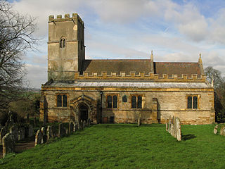
Slipton is a village and former civil parish, now in the parish of Lowick, in the North Northamptonshire district, in the ceremonial county of Northamptonshire, England. Slipton has a small but exquisite church, St John The Baptist, a short walk from Main Street by footpath on the east side of the village. The church is what makes Slipton a village rather than a hamlet as it is often mistaken for. In 1931 the parish had a population of 80.

Easton Neston is situated in south Northamptonshire, England. Though the village of Easton Neston which was inhabited until around 1500 is now gone, the parish retains the name. At the 2011 Census the population of the civil parish remained less than 100 and was included in the town of Towcester.
The Kettering, Thrapston and Huntingdon Railway was an English railway line opened throughout in 1866. It connected the Midland Railway main line at Kettering to ironstone deposits to the south-east of the town, as well as opening up the agricultural district around Thrapston and reaching the regional centre of Huntingdon. The hoped-for expansion of agricultural was limited and local traffic did not develop; at the same time the difficult alignment and gradients of the line discouraged heavy use as a through line. A basic passenger service operated through from Kettering to Cambridge, by using running powers east of Huntingdon via St Ives.

