
The 2005 Pacific typhoon season was the least active typhoon season since 2000, producing 23 named storms, of which 13 became typhoons. It was an event in the annual cycle of tropical cyclone formation, in which tropical cyclones form in the western Pacific Ocean. The season ran throughout 2005, though most tropical cyclones typically develop between May and October. The season's first named storm, Kulap, developed on January 13, while the season's last named storm, Bolaven, dissipated on November 20. The season's first typhoon, Haitang, reached typhoon status on July 13, and became the first super typhoon of the year three days later.

The 2006 Pacific typhoon season was a destructive and deadly season, although it was near-average in terms of activity with a total of 23 named storms, 15 typhoons, and six super typhoons. Compared to the previous season, more typhoons inflicted damage across several countries, particularly China and the Philippines, some of which made landfall at higher intensities. The ratio of intense typhoons to all typhoons is at 0.73, the highest since 1970.

The 2004 Pacific typhoon season was an extremely active season that featured the second-highest ACE ever recorded in a single season, second only to 1997, which featured 29 named storms, nineteen typhoons, and six super typhoons. It was an event in the annual cycle of tropical cyclone formation, in which tropical cyclones form in the western Pacific Ocean. The season ran throughout 2004, though most tropical cyclones typically develop between May and October. The season's first named storm and also the first typhoon, Sudal, developed on April 4, later was reached typhoon status two days later, and became the first super typhoon of the year three days later. The season's last named storm, Noru, dissipated on December 22.

The 2003 Pacific typhoon season was a slightly below average yearlong period of tropical cyclogenesis exhibiting the development of 45 tropical depressions, of which 21 became named storms; of those, 14 became typhoons. Though every month with the exception of February and March featured tropical activity, most storms developed from May through October. During the season, tropical cyclones affected the Philippines, Japan, China, the Korean Peninsula, Indochina, and various islands in the western Pacific.

The 2000 Pacific typhoon season marked the first year using names contributed by the World Meteorological Organization. It was a rather below-average season, producing a total of 23 tropical storms, 13 typhoons and 4 intense typhoons. The season ran throughout 2000, though typically most tropical cyclones develop between May and October. The season's first named storm, Damrey, developed on May 7, while the season's last named storm, Soulik, dissipated on January 4 of the next year. The Accumulated Cyclone Energy (ACE) index for the 2000 Pacific typhoon season as calculated by Colorado State University using data from the Joint Typhoon Warning Center was 252.9 units.

The 1998 Pacific typhoon season was the least active Pacific typhoon season on record, until it was surpassed 12 years later. It would produce 16 tropical storms, 8 strengthening into typhoons. The scope of this article is limited to the Pacific Ocean, north of the equator and west of the International Date Line. Storms that form east of the date line and north of the equator are called hurricanes; see 1998 Pacific hurricane season. Tropical Storms formed in the entire west Pacific basin were assigned a name by the Joint Typhoon Warning Center. Tropical depressions in this basin have the "W" suffix added to their number. Tropical depressions that enter or form in the Philippine area of responsibility are assigned a name by the Philippine Atmospheric, Geophysical and Astronomical Services Administration or PAGASA. This can often result in the same storm having two names.

The 1996 Pacific typhoon season was an above average season, producing 30 tropical storms, 16 typhoons and six super typhoons. It has no official bounds; it ran year-round in 1996, but most tropical cyclones tend to form in the northwestern Pacific Ocean between May and November. These dates conventionally delimit the period of each year when most tropical cyclones form in the northwestern Pacific Ocean. However the first named storm, Ann, did not develop until April 3. The final named storm, Greg, dissipated on December 27.

The 1995 Pacific typhoon season was a slightly below average season in terms of named storms, ending a 6-year stretch of above average activity. It occurred all year round, though most tropical cyclones formed between May and November.

The 1994 Pacific typhoon season was the seventh and final consecutive to have above average tropical cyclone activity, but also it was the extremely active season in the annual cycle of tropical cyclone formation in the Western North Pacific, being the second most active season in the basin, only behind 1964. With a total of 36 tropical storms, where 20 of them reached typhoon strength and 6 further strengthening into super typhoons, during the course of the season, much like the Pacific hurricane season. The season had no official bounds and it ran year-round in 1994, but most tropical cyclones tend to form in the northwestern Pacific Ocean between May and November. Tropical storms that formed west of the date line were assigned a name by the Joint Typhoon Warning Center. The World Meteorological Organization-designated Regional Specialized Meteorological Centre for tropical cyclones for the region is the Japan Meteorological Agency. Tropical depressions that entered or formed in the Philippine area of responsibility were assigned a name by the Philippine Atmospheric, Geophysical and Astronomical Services Administration or PAGASA. This can result in some storms having two names.

The 1992 Pacific typhoon season was the fourth consecutive above-average season, producing 31 tropical storms, 16 typhoons and five super typhoons. It had no official bounds; it ran year-round in 1992. Despite this, most tropical cyclones tend to form in the northwestern Pacific Ocean between May and November. These dates conventionally delimit the period of each year when most tropical cyclones form in the northwestern Pacific Ocean.

The 1991 Pacific typhoon season was a slightly above-average season with 29 tropical storms, 17 typhoons and five super typhoons forming. It was quite a catastrophic season – Typhoon Yunya impacted the Philippines in mid June while in the same time experiencing a volcanic eruption, Typhoon Mireille severely impacting Japan, which became known for being the costliest typhoon on record until it was surpassed by Typhoon Doksuri in 2023, and Tropical Storm Thelma on November which became one of the deadliest storms to strike the Philippines, killing at least over 5,000 people.

The 1990 Pacific typhoon season was another active season. It has no official bounds; it ran year-round in 1990, but most tropical cyclones tend to form in the northwestern Pacific Ocean between May and November. These dates conventionally delimit the period of each year when most tropical cyclones form in the northwestern Pacific Ocean.

The 1989 Pacific typhoon season was the second consecutive to have above average tropical cyclone activity. It was an extremely active season reaching 32 tropical storms, 20 typhoons and five super typhoons. It has no official bounds; it ran year-round in 1989, but most tropical cyclones tend to form in the northwestern Pacific Ocean between May and November. These dates conventionally delimit the period of each year when most tropical cyclones form in the northwestern Pacific Ocean. The first storm, Winona, formed on January 15, while the final storm, Jack, dissipated on December 27. This season was also quite a deadly season that were caused by a few notable storms such as Tropical Storm Cecil, which was the worst storm to impact Vietnam in over 50 years, and Typhoon Gay, which directly impacted the Malay Peninsula as the worst typhoon in 35 years. Both of these storms make up around half of the total fatalities of the entire season alone.
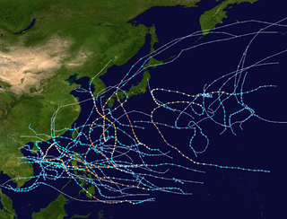
The 1970 Pacific typhoon season has no official bounds; it ran year-round in 1970, but most tropical cyclones tend to form in the northwestern Pacific Ocean between June and December. These dates conventionally delimit the period of each year when most tropical cyclones form in the northwestern Pacific Ocean.

The 1972 Pacific typhoon season was an above average season, producing 31 tropical storms, 24 typhoons and 2 intense typhoons. It has no official bounds; it ran year-round in 1972, but most tropical cyclones tend to form in the northwestern Pacific Ocean between June and December. These dates conventionally delimit the period of each year when most tropical cyclones form in the northwestern Pacific Ocean.

The 1960 Pacific typhoon season had no official bounds; it ran year-round in 1960, but most tropical cyclones tend to form in the northwestern Pacific Ocean between June and December. These dates conventionally delimit the period of each year when most tropical cyclones form in the northwestern Pacific Ocean.

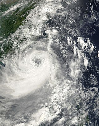
Severe Tropical Storm Bilis, known in the Philippines as Tropical Storm Florita, was a severe tropical storm in July 2006 that caused catastrophic damage to areas of the Philippines, Taiwan, and southeastern China. The word Bilis, submitted by the Philippines, means 'speed' or 'swiftness' in Tagalog.
Severe Tropical Storm Utor, known in the Philippines as Typhoon Feria, was a large and deadly system that caused heavy rains and landslides throughout the Philippines, Taiwan, and China. The eighth tropical depression and fourth named storm of the 2001 Pacific typhoon season, Utor formed on July 1 and intensified into a tropical storm shortly after. Utor was upgraded to a typhoon by the JTWC on July 3, and a day later, Utor was estimated to have peaked with 10-min winds of 110 km/h (70 mph), with the JTWC estimating 1-min winds of 150 km/h (95 mph). After passing just north of Luzon, Utor began to weaken, before making landfall on the district of Dapeng as a minimal typhoon. Utor caused 203 deaths, of which 168 were in the Philippines, 23 were in the province of Guangdong, 10 were in the province of Guangxi, and 2 were in Taiwan. Total damages from the storm amounted to $2.78 billion.


