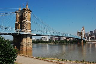
The John A. Roebling Suspension Bridge is a suspension bridge that spans the Ohio River between Cincinnati, Ohio, and Covington, Kentucky. When opened on December 1, 1866, it was the longest suspension bridge in the world at 1,057 feet (322 m) main span, which was later overtaken by John A. Roebling's most famous design of the 1883 Brooklyn Bridge at 1,595.5 feet (486.3 m). Pedestrians use the bridge to get between the hotels, bars, restaurants, and parking lots in Northern Kentucky. The bar and restaurant district at the foot of the bridge on the Kentucky side is known as Roebling Point.
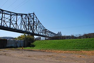
The Carl D. Perkins Bridge is a cantilever bridge that spans the Ohio River between Washington Township, Scioto County, Ohio and South Portsmouth, Greenup County, Kentucky. The bridge carries the two lanes of State Route 852 and Truck Route U.S. Highway 23. The bridge connects to Kentucky Route 8.

The Oregon City Bridge, also known as the Arch Bridge, is a steel through arch bridge spanning the Willamette River between Oregon City and West Linn, Oregon, United States. Completed in 1922, it is listed on the National Register of Historic Places. It was built and is owned by the Oregon Department of Transportation (ODOT) as part of Oregon Route 43 and is the third-southernmost Willamette bridge in the Portland metropolitan area, after the Boone Bridge in Wilsonville and the Oregon 219 bridge near Newberg.

The Waco Suspension Bridge crosses the Brazos River in Waco, Texas. It is a single-span suspension bridge, with a main span of 475 ft. Opened on November 20, 1869, it contains nearly 3 million bricks. It is located north of downtown Waco, connecting Indian Spring Park with Doris D. Miller Park. Every year on Independence Day, the bridge serves as a place where thousands of locals gather to watch fireworks. Indian Spring Park marks the location of the origin of the town of Waco, where the Huaco Indians had settled on the bank of the river, at the location of a cold spring.

The Wheeling Suspension Bridge is a suspension bridge spanning the main channel of the Ohio River at Wheeling, West Virginia. It was the largest suspension bridge in the world from 1849 until 1851. Charles Ellet Jr. designed it and supervised construction of what became the first bridge to span a major river west of the Appalachian mountains. It linked the eastern and western section of the National Road, and became especially strategically important during the American Civil War. Litigation in the United States Supreme Court concerning its obstruction of the new high steamboat smokestacks eventually cleared the way for other bridges, especially needed by expanding railroads. Because this bridge was designed during the horse-and-buggy era, 2-ton weight limits and vehicle separation requirements applied in later years until it was closed to automobile traffic in September 2019.

The Mount Hope Bridge is a two-lane suspension bridge spanning the Mount Hope Bay in eastern Rhode Island at one of the narrowest gaps in Narragansett Bay. The bridge connects the Rhode Island towns of Portsmouth and Bristol and is part of Route 114. Its towers are 285 feet (87 m) tall, the length of the main span is 1,200 feet (370 m), and it offers 135 feet (41 m) of clearance over high water. The total length of the bridge is 6,130 feet (1,870 m).

The Ryde Bridge, also called the Uhrs Point Bridge, are two road bridges that carry Concord Road, part of the A3, across Parramatta River from Ryde in the northern suburbs of Sydney to Rhodes in Sydney's inner west, in New South Wales, Australia.

The Brent Spence Bridge is a double decker, cantilevered truss bridge that carries Interstates 71 and 75 across the Ohio River between Covington, Kentucky and Cincinnati, Ohio. The top deck carries Kentucky-bound traffic while the bottom deck carries Ohio-bound traffic.

Interstate 470 (I-470) is a 10.63-mile-long (17.11 km) auxiliary Interstate Highway of I-70 that bypasses the city of Wheeling, West Virginia, United States. I-470 is one of 13 auxiliary Interstate Highways in Ohio and the only auxiliary Interstate Highway in West Virginia. The western terminus of I-470 is an interchange with I-70 in Richland Township, Ohio. Traveling southeast through rural Belmont County, I-470 approaches the Vietnam Veterans Memorial Bridge, which spans the Ohio River. After crossing the river into Ohio County, West Virginia, the highway continues east toward the Wheeling communities of Bethlehem and Elm Grove and its eastern terminus at I-70 near Elm Grove. The portion of the highway in West Virginia is named the USS West Virginia Memorial Highway by proclamation of then-Governor Cecil H. Underwood on the 59th anniversary of the attack on Pearl Harbor.

The Waldo–Hancock Bridge was the first long-span suspension bridge erected in Maine, as well as the first permanent bridge across the Penobscot River downstream from Bangor. The name comes from connecting Waldo and Hancock counties. The bridge was built in 1931 and retired in 2006, when the new Penobscot Narrows Bridge was opened just a few yards away, and it was demolished in 2013.

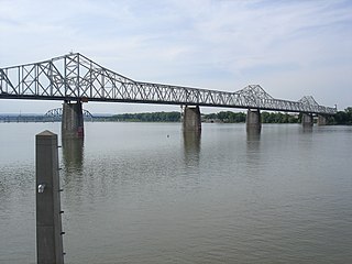
The Sherman Minton Bridge is a double-deck through arch bridge spanning the Ohio River, carrying I-64 and US 150 over the river between Kentucky and Indiana. The bridge connects the west side of Louisville, Kentucky to downtown New Albany, Indiana.

The Simon Kenton Memorial Bridge is a suspension bridge built in 1931 that carries U.S. Route 62 across the Ohio River to connect Maysville, Kentucky with Aberdeen, Ohio. Its main span is 1,060 feet long, and the total length of the bridge is 1,991 feet. The bridge was designed by Modjeski and Masters and was open to traffic on November 25, 1931. Tolls were collected from the opening of the bridge until 1945.

The Milton–Madison Bridge is a continuous truss bridge that connects Milton, Kentucky and Madison, Indiana. It carries approximately 10,000 cars a day. The old structure was replaced with a completely new continuous truss which was constructed on temporary piers adjacent to the operational span between 2011 and 2012 and slid into place after demolition of the old span using a construction method called "truss sliding." The new crossing opened to vehicle traffic in April 2014, and a pedestrian sidewalk opened that October.

The Bellaire Bridge or Interstate Bridge is a privately owned, closed cantilever truss toll bridge that spans the Ohio River between Benwood, West Virginia and Bellaire, Ohio. It provided a link for commuters between southern Ohio border towns and West Virginia steel mills from 1926 to 1991.

The Fort Henry Bridge is a crossing of the Ohio River main channel in Wheeling, West Virginia. The tied-arch bridge carries two lanes in each direction of Interstate 70 (I-70), U.S. Route 40 (US 40), and US 250. The bridge opened after four years of construction work on September 8, 1955, costing $6.8 million, $1.8 million over budget. The bridge, along with the aging Wheeling Suspension Bridge, are the only two road links from Wheeling Island to downtown Wheeling, although this is the only one that allows vehicular traffic. In 2009, the structure carried an average of over 60,000 vehicles per day.

The Ironton–Russell Bridge can refer to either one of two bridges that carry/carried traffic along the Ohio River between Ironton, Ohio and Russell, Kentucky in the United States. The original blue cantilever Ironton–Russell Bridge, opened in 1922 and closed in 2016, carried two lanes of traffic and a narrow sidewalk. The new white cable-stayed bridge, officially named the Oakley C. Collins Memorial Bridge, has two lanes of traffic without a dedicated sidewalk and opened on November 23, 2016.

The George Rogers Clark Memorial Bridge, known locally as the Second Street Bridge, is a four-lane cantilevered truss bridge crossing the Ohio River between Louisville, Kentucky, and Jeffersonville, Indiana, that carries US 31.

The World War I Memorial Bridge is a vertical-lift bridge that carries U.S. Route 1 across the Piscataqua River between Portsmouth, New Hampshire, and Badger's Island in Kittery, Maine, United States. The current bridge was opened in 2013, replacing a bridge of similar design that existed from 1923 to 2012. A large overhead plaque carried over from the original reads "Memorial to the Sailors and Soldiers of New Hampshire who gave their lives in the World War 1917–1919."

The Benjamin Franklin Bridge, originally named the Delaware River Bridge and known locally as the Ben Franklin Bridge, is a suspension bridge across the Delaware River connecting Philadelphia, Pennsylvania, and Camden, New Jersey. Owned and operated by the Delaware River Port Authority, it is one of four primary vehicular bridges between Philadelphia and southern New Jersey, along with the Betsy Ross, Walt Whitman, and Tacony-Palmyra bridges. It carries Interstate 676/U.S. Route 30, pedestrians/cyclists, and the PATCO Speedline.

The Market Street Bridge is a suspension bridge connecting Market Street in Steubenville, Ohio and West Virginia Route 2 in Follansbee, West Virginia over the Ohio River. As a project of the Steubenville Bridge Company, it was constructed in 1905 by the Ohio Steel Erection Company, the framework was created by the Penn Bridge Company, and the original steel was done by Jones and Laughlin Steel Company and Bethlehem Steel. The bridge spans a length of 1,794 feet (547 m) with a width of 20.7 feet (6.3 m). As of 2002, the average daily traffic was estimated around 15,000 vehicles. It was listed on the National Register of Historic Places in 2019.


