
The McAlpine Locks and Dam are a set of locks and a hydroelectric dam at the Falls of the Ohio River at Louisville, Kentucky. They are located at mile point 606.8, and control a 72.9 miles (117.3 km) long navigation pool. The locks and their associated canal were the first major engineering project on the Ohio River, completed in 1830 as the Louisville and Portland Canal, designed to allow shipping traffic to navigate through the Falls of the Ohio.
Transportation in West Virginia includes the following.

Lock and Dam No. 15 is a lock and dam located on the Upper Mississippi River. It spans the river between Rock Island, Illinois and Davenport, Iowa. Lock and Dam 15 is the largest roller dam in the world, its dam is 1,203 feet (366.7 m) long and consists of nine 109 feet (33.2 m) non-submersible, non-overflow roller gates and two 109 feet (33.2 m) non-submersible overflow roller gates. It is unusual among the upper Mississippi River dams in that it has only roller gates, has different sizes and types of roller gates, it is not perpendicular to the flow of the river and is one of the few facilities that has a completed auxiliary lock. The main lock is 110 feet (33.5 m) wide by 600 feet (180 m) long and its auxiliary lock is 110 feet (34 m) wide by 360 feet (110 m) long. In 2004, the facility was listed in the National Register of Historic Places as Lock and Dam No. 15 Historic District, #04000175 covering 3,590 acres (1,450 ha), 2 buildings, 9 structures, and 1 object.
The John T. Myers Locks and Dam is the 17th Lock and dam on the Ohio River located 846 miles downstream of Pittsburgh about 3 miles (4.8 km) downstream from Uniontown, Kentucky. There are two locks, one for commercial barge traffic that is 1,200 feet long by 110 feet wide, and the auxiliary lock is 600 feet long by 110 feet wide. This United States Army Corps of Engineers facility is in Posey County, Indiana, and Union County, Kentucky. The project was authorized as replacement for existing Locks and Dam 48 and 49 on September 17, 1958, by Secretary of the Army under authority of Section 6 of the Rivers and Harbors Act approved March 3, 1909, as amended.

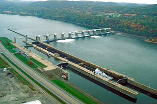
The Cannelton Locks and Dam is a tainter-gated dam with two locks on the Ohio River, on the border between the U.S. states of Indiana and Kentucky. The dam is 2 miles (3.2 km) southeast of Cannelton, Indiana. Construction of the locks began in July 1963. The locks began operation in December 1966 and were completed April 1967. Construction on the dam started in August 1965 and the dam was completed in 1974. The structure was designed, built, and is operated by the United States Army Corps of Engineers Louisville District.
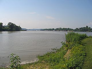
The Port of Huntington Tri-State, centered on the Ohio River in Huntington, West Virginia, is the largest inland port in the United States. It is the largest river port in the state of West Virginia and the 15th-largest in the United States as of 2012. Included in the port's area is 100 miles of the Ohio River from the mouth of the Scioto River in Portsmouth, Ohio to the northern border of Gallia County, Ohio, 9 miles of the Big Sandy River, and 90 miles of the Kanawha River. The United States Army Corps of Engineers' 1953 Ohio River Navigation Modernization Program sited the Greenup Locks and Dam project as an early priority so that its pool could serve the Port of Huntington Tri-State. It exceeded Pittsburgh in 1953 as the busiest port on the waterway.

Emsworth Locks and Dam is a combination of locks and dam on the Ohio River located just down stream of Pittsburgh. The dam has two gated sections, one on each side of Neville Island. There are two locks, one for commercial barge traffic that is 600 feet long by 110 feet wide, and the recreational auxiliary lock that is 360 feet long by 56 feet wide. Emsworth averages about 470 commercial lock throughs every month and 350-400 lock throughs a month on the recreational auxiliary lock.

Dashields Lock and Dam is a fixed-crest dam on the Ohio River. It is located less than 15 miles down stream of Pittsburgh. There are two locks, one for commercial barge traffic that's 600 feet long by 110 feet wide, and the recreational auxiliary lock is 360 feet long by 56 feet wide. Dashields locks averages about 450 commercial lock throughs every month and 200-300 lock throughs a month on the recreational auxiliary lock.

Montgomery Locks and Dam is a lock and dam on the Ohio River, located 32 miles downstream of Pittsburgh. There are two locks, one for commercial barge traffic that's 600 feet long by 110 feet wide, and the recreational auxiliary lock is 360 feet long by 56 feet wide. Montgomery locks averages about 300 commercial lock throughs every month and 150 lock throughs a month on the recreational auxiliary lock. The average cost to keep the lock and dam operationally ready averaged $5.8 million per year from the years 2010-2014.
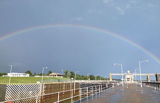
New Cumberland Lock and Dam is the fourth lock and dam on the Ohio River, located 54 miles downstream of Pittsburgh. There are two locks, one for commercial barge traffic that's 1,200 feet long by 110 feet wide, and the recreational auxiliary lock is 600 feet long by 110 feet wide. New Cumberland locks averages about 320 commercial lock throughs every month and 120 lock throughs a month on the recreational auxiliary lock.

Pike Island Lock and Dam is the fifth lock and dam on the Ohio River, located 84 miles downstream of Pittsburgh. There are two locks, one for commercial barge traffic that's 1,200 feet long by 110 feet wide, and the auxiliary lock is 600 feet long by 110 feet wide.

Willow Island Lock and Dam is the 7th Lock and dam on the Ohio River, located 162 miles downstream of Pittsburgh. There are two locks, one for commercial barge traffic that's 1,200 feet long by 110 feet wide, and the auxiliary lock is 600 feet long by 110 feet wide.
Belleville Lock and Dam is the 8th Lock and dam on the Ohio River, located 204 miles downstream of Pittsburgh. There are two locks, one for commercial barge traffic that's 1,200 feet long by 110 feet wide, and the auxiliary lock is 600 feet long by 110 feet wide.
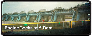
Racine Lock and Dam is the ninth lock and dam on the Ohio River. It is located 238 miles downstream from Pittsburgh. There are two locks, one for commercial barge traffic 1,200 feet long by 110 feet wide, and the auxiliary lock, which is 600 feet long by 110 feet wide.

The Robert C. Byrd Lock and Dam, formerly the Gallipolis Lock and Dam, is the 10th lock and dam on the Ohio River, located 280 miles downstream from Pittsburgh. There are 4 locks: one for commercial barge traffic, 1,200 feet long by 110 feet wide; the auxiliary lock is 600 feet long by 110 feet wide; and there are 2 smaller parallel locks.
Newburgh Lock and Dam is the 16th lock and dam on the Ohio River, located 776 miles (1,249 km) down stream of Pittsburgh.There are two locks. The main lock for commercial barge traffic that is 1,200 feet (370 m) long by 110 feet (34 m) wide, and the auxiliary lock is 600 feet (180 m) by 110 feet (34 m) wide.
Smithland Lock and Dam is the 18th lock and dam on the Ohio River, 919 miles down stream of Pittsburgh and 63 miles upstream from the confluence of the Mississippi with the Ohio. There are 2 locks for commercial barge traffic that are 1,200 feet long by 110 feet wide.

Lock and Dam 52 was the 19th lock and dam on the Ohio River. It is 939 miles downstream of Pittsburgh and 23 miles upstream from the confluence of the Mississippi with the Ohio.

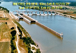
Lock and Dam 53 was the 20th lock and dam upstream from the confluence of the Ohio River and the Mississippi River. It was located 962 miles downstream from Pittsburgh. Lock and Dam 53 had two locks for commercial barge traffic, one that was 1,200 feet long by 110 feet wide, the other 600 feet long by 110 feet wide. The lock will be demolished and Olmsted Lock and Dam will replace it.

