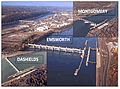
| Montgomery Locks and Dam | |
|---|---|
 | |
| Official name | Montgomery Locks and Dam |
| Coordinates | 40°39′01″N80°23′10″W / 40.6503°N 80.3860°W |
| Construction began | 1932 |
| Opening date | June 1936 |
| Operator(s) | |
| Dam and spillways | |
| Type of dam | Gated |
| Impounds | Ohio River |
| Length | 1,379 feet |
| Reservoir | |
| Normal elevation | 682 feet above sealevel |
The Montgomery Locks and Dam are part of a lock and dam system that is located on the Ohio River in the United States.