
The Ohio River is a 981-mile (1,579 km) long river in the United States. It is located at the boundary of the Midwestern and Southern United States, flowing southwesterly from far-western Pennsylvania south of Lake Erie to its mouth on the Mississippi River at the southern tip of Illinois. It is the third largest river by discharge volume in the United States and the largest tributary by volume of the north-south flowing Mississippi River that divides the eastern from western United States. The river flows through or along the border of six states, and its drainage basin includes parts of 14 states. Through its largest tributary, the Tennessee River, the basin includes several states of the southeastern U.S. It is the source of drinking water for three million people.

The McAlpine Locks and Dam are a set of locks and a hydroelectric dam at the Falls of the Ohio River at Louisville, Kentucky. They are located at mile point 606.8, and control a 72.9 miles (117.3 km) long navigation pool. The locks and their associated canal were the first major engineering project on the Ohio River, completed in 1830 as the Louisville and Portland Canal, designed to allow shipping traffic to navigate through the Falls of the Ohio.

The Markland Locks and Dam is a concrete dam bridge and locks that span the Ohio River. It is 1395 feet long, and connects Gallatin County, Kentucky, and Switzerland County, Indiana.
The John T. Myers Locks and Dam is the 17th Lock and dam on the Ohio River located 846 miles downstream of Pittsburgh about 3 miles (4.8 km) downstream from Uniontown, Kentucky. There are two locks, one for commercial barge traffic that is 1,200 feet long by 110 feet wide, and the auxiliary lock is 600 feet long by 110 feet wide. This United States Army Corps of Engineers facility is in Posey County, Indiana, and Union County, Kentucky. The project was authorized as replacement for existing Locks and Dam 48 and 49 on September 17, 1958, by Secretary of the Army under authority of Section 6 of the Rivers and Harbors Act approved March 3, 1909, as amended.

The Cannelton Locks and Dam is a tainter-gated dam with two locks on the Ohio River, on the border between the U.S. states of Indiana and Kentucky. The dam is 2 miles (3.2 km) southeast of Cannelton, Indiana. Construction of the locks began in July 1963. The locks began operation in December 1966 and were completed April 1967. Construction on the dam started in August 1965 and the dam was completed in 1974. The structure was designed, built, and is operated by the United States Army Corps of Engineers Louisville District.
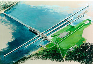
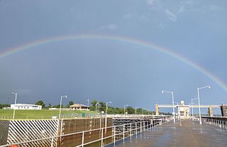
The Olmsted Locks and Dam is a locks and wicket dam on the Ohio River at river mile 964.4. The project is intended to reduce tow and barge delays by replacing the existing older, and frequently congested, locks and dams Number 52 and Number 53. The locks are located about 17 miles upstream from the confluence of the Ohio and Mississippi rivers at Olmsted, Illinois.

Emsworth Locks and Dam is a combination of locks and dam on the Ohio River located just down stream of Pittsburgh. The dam has two gated sections, one on each side of Neville Island. There are two locks, one for commercial barge traffic that is 600 feet long by 110 feet wide, and the recreational auxiliary lock that is 360 feet long by 56 feet wide. Emsworth averages about 470 commercial lock throughs every month and 350-400 lock throughs a month on the recreational auxiliary lock.

Dashields Lock and Dam is a fixed-crest dam on the Ohio River. It is located less than 15 miles down stream of Pittsburgh. There are two locks, one for commercial barge traffic that's 600 feet long by 110 feet wide, and the recreational auxiliary lock is 360 feet long by 56 feet wide. Dashields locks averages about 450 commercial lock throughs every month and 200-300 lock throughs a month on the recreational auxiliary lock.

Montgomery Locks and Dam is a lock and dam on the Ohio River, located 32 miles downstream of Pittsburgh. There are two locks, one for commercial barge traffic that's 600 feet long by 110 feet wide, and the recreational auxiliary lock is 360 feet long by 56 feet wide. Montgomery locks averages about 300 commercial lock throughs every month and 150 lock throughs a month on the recreational auxiliary lock. The average cost to keep the lock and dam operationally ready averaged $5.8 million per year from the years 2010-2014.
New Cumberland Lock and Dam is the fourth lock and dam on the Ohio River, located 54 miles downstream of Pittsburgh. There are two locks, one for commercial barge traffic that's 1,200 feet long by 110 feet wide, and the recreational auxiliary lock is 600 feet long by 110 feet wide. New Cumberland locks averages about 320 commercial lock throughs every month and 120 lock throughs a month on the recreational auxiliary lock.

Pike Island Lock and Dam is the fifth lock and dam on the Ohio River, located 84 miles downstream of Pittsburgh. There are two locks, one for commercial barge traffic that's 1,200 feet long by 110 feet wide, and the auxiliary lock is 600 feet long by 110 feet wide.

Willow Island Lock and Dam is the 7th Lock and dam on the Ohio River, located 162 miles downstream of Pittsburgh. There are two locks, one for commercial barge traffic that's 1,200 feet long by 110 feet wide, and the auxiliary lock is 600 feet long by 110 feet wide.
Belleville Lock and Dam is the 8th Lock and dam on the Ohio River, located 204 miles downstream of Pittsburgh. There are two locks, one for commercial barge traffic that's 1,200 feet long by 110 feet wide, and the auxiliary lock is 600 feet long by 110 feet wide.
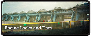
Racine Lock and Dam is the ninth lock and dam on the Ohio River. It is located 238 miles downstream from Pittsburgh. There are two locks, one for commercial barge traffic 1,200 feet long by 110 feet wide, and the auxiliary lock, which is 600 feet long by 110 feet wide.

The Robert C. Byrd Lock and Dam, formerly the Gallipolis Lock and Dam, is the 10th lock and dam on the Ohio River, located 280 miles downstream from Pittsburgh. There are 4 locks: one for commercial barge traffic, 1,200 feet long by 110 feet wide; the auxiliary lock is 600 feet long by 110 feet wide; and there are 2 smaller parallel locks.
Greenup Lock and Dam is the 11th Lock and dam on the Ohio River, located 341 miles downstream of Pittsburgh. There are 2 locks, one for commercial barge traffic that's 1,200 feet long by 110 feet wide, and the auxiliary lock is 600 feet long by 110 feet wide.
Newburgh Lock and Dam is the 16th lock and dam on the Ohio River, located 776 miles (1,249 km) down stream of Pittsburgh.There are two locks. The main lock for commercial barge traffic that is 1,200 feet (370 m) long by 110 feet (34 m) wide, and the auxiliary lock is 600 feet (180 m) by 110 feet (34 m) wide.

Lock and Dam 52 was the 19th lock and dam on the Ohio River. It is 939 miles downstream of Pittsburgh and 23 miles upstream from the confluence of the Mississippi with the Ohio.

Lock and Dam 53 was the 20th lock and dam upstream from the confluence of the Ohio River and the Mississippi River. It was located 962 miles downstream from Pittsburgh. Lock and Dam 53 had two locks for commercial barge traffic, one that was 1,200 feet long by 110 feet wide, the other 600 feet long by 110 feet wide. The lock will be demolished and Olmsted Lock and Dam will replace it.

