| Dashields Locks and Dam (formerly Deadman Island Locks and Dam) | |
|---|---|
 | |
| Official name | Dashields Locks and Dam |
| Coordinates | 40°33′02″N80°12′15″W / 40.5506°N 80.2041°W |
| Construction began | 1927 |
| Opening date | 1929 |
| Operator(s) | |
| Dam and spillways | |
| Type of dam | fixed crest dam |
| Impounds | Ohio River |
| Length | 1,585 feet |
| Reservoir | |
| Normal elevation | 692 feet above sealevel |
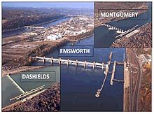
Dashields Lock and Dam is a fixed-crest dam on the Ohio River. [1] [2] It is located less than 15 miles down stream of Pittsburgh. There are two locks, one for commercial barge traffic that is 600 feet long by 110 feet wide, and a recreational auxiliary lock that is 360 feet long by 56 feet wide. [3] Dashields locks averages about 450 commercial lock throughs every month and 200-300 lock throughs a month on the recreational auxiliary lock.
Contents