Ubundu

Last updated
Ubundu
New vessel for Fort Tango, on the Congo River.jpg
Ubundu is a port on the Congo River, about a 100 km up a muddy road from Kisangani.
Democratic Republic of the Congo adm location map.svg
Red pog.svg
Ubundu
Coordinates: 0°21′32″S25°26′00″E / 0.358813°S 25.433221°E / -0.358813; 25.433221
CountryFlag of the Democratic Republic of the Congo.svg  DR Congo
Province Tshopo
Territory Ubundu
Time zone UTC+2 (CAT)
Climate Tropical raninforest (Af)
National language Swahili

Ubundu, formerly known as Ponthierville or Ponthierstad, is a town located in the Tshopo Province of the Democratic Republic of the Congo and is the administrative center of the territory of the same name. It is on the Lualaba River, or Upper Congo, just above the Boyoma Falls.

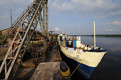
As the river is not navigable from here downstream to Kisangani, a portage railway was built to link the settlement to Kisangani. It was built and operated during the colonial era by the Compagnie du chemin de fer du Congo supérieur aux Grands Lacs africains of CFL (1902-1960) whose rail and river steamer service connected Kisangani with Katanga. Upstream from Ubundu the river is navigable as far as Kasongo.

In 1951, Katharine Hepburn, Humphrey Bogart and the crew of the film The African Queen arrived in Ubundu by train for filming in the jungle. In those days, the town was described as a "pretty colonial outpost". [1]

The area saw some of the worst fighting during the Second Congo War. Around 2003, the town had no electricity, and very few facilities, and was considered a very dangerous place. [2]

See also

Related Research Articles

<span class="mw-page-title-main">Transport in the Democratic Republic of the Congo</span> Transport systems in the Democratic Republic of the Congo

Ground transport in the Democratic Republic of the Congo (DRC) has always been difficult. The terrain and climate of the Congo Basin present serious barriers to road and rail construction, and the distances are enormous across this vast country. Furthermore, chronic economic mismanagement and internal conflict has led to serious under-investment over many years.

<span class="mw-page-title-main">Matadi</span> Provincial capital and city in Kongo Central, Democratic Republic of the Congo

Matadi is the chief sea port of the Democratic Republic of the Congo and the capital of the Kongo Central province, adjacent to the border with Angola. It had a population of 245,862 (2004). Matadi is situated on the left bank of the Congo River, 148 km (92 mi) from the mouth and 8 km (5.0 mi) below the last navigable point before the rapids that make the river impassable for a long stretch upriver. It was founded by Sir Henry Morton Stanley in 1879.

<span class="mw-page-title-main">Lualaba River</span> River in Democratic Republic of the Congo

The Lualaba River flows entirely within the eastern part of Democratic Republic of the Congo. It provides the greatest streamflow to the Congo River, while the source of the Congo is recognized as the Chambeshi. The Lualaba is 1,800 kilometres (1,100 mi) long. Its headwaters are in the country's far southeastern corner near Musofi and Lubumbashi in Katanga Province, next to the Zambian Copperbelt.

<span class="mw-page-title-main">Pool Malebo</span> Widening of the Congo River; part of the border between the R Congo and the DR Congo

The Pool Malebo, formerly Stanley Pool, also known as Mpumbu, Lake Nkunda or Lake Nkuna by local indigenous people in pre-colonial times, is a lake-like widening in the lower reaches of the Congo River. The river serves as the border between the Republic of the Congo on the north and the Democratic Republic of the Congo to the south.

<span class="mw-page-title-main">Kisangani</span> City in the northeastern DR Congo

Kisangani is the capital of Tshopo province in the Democratic Republic of the Congo. It is the fifth most populous urban area in the country, with an estimated population of 1,312,000 in 2021, and the largest of the cities that lie in the tropical woodlands of the Congo.

Ilebo, formerly known as Port-Francqui, is a town in Kasai province in the Democratic Republic of Congo, lying at the highest navigable point of the Kasaï River. It is an important transport hub for ferries to Kinshasa and trains to Lubumbashi.

<span class="mw-page-title-main">University of Lubumbashi</span> University in Democratic Republic of the Congo

The University of Lubumbashi, also known by the acronym UNILU, is one of the largest universities in the Democratic Republic of the Congo. It is located in Lubumbashi in Haut-Katanga Province, previously Katanga Province. The campus is located in the northern part of the city, west of the airport.

<span class="mw-page-title-main">Rail transport in the Democratic Republic of the Congo</span> Overview of rail transport in the Democratic Republic of the Congo

Rail transport is provided in the Democratic Republic of the Congo by the Société Nationale des Chemins de Fer du Congo (SNCC), the Société commerciale des transports et des ports (SCTP) (previously Office National des Transports until 2011), and the Office des Chemins de fer des Ueles (CFU).

<span class="mw-page-title-main">Aketi (town)</span> Place in Bas-Uele, Democratic Republic of the Congo

Aketi is a town in the Bas-Uele Province of the Democratic Republic of the Congo. It is the seat of Aketi Territory. As of 2009 it had an estimated population of 38,588.

Ligne Aérienne du Roi Albert was a short-lived civilian airline in the Belgian Congo colony.

Isangi is a town in the Tshopo Province of the Democratic Republic of the Congo, headquarters of Isangi Territory.

<span class="mw-page-title-main">Yakusu</span> Place in Tshopo, DR Congo

Yakusu was a mission in the Democratic Republic of the Congo, on the Congo River just west and downstream of Kisangani.

<span class="mw-page-title-main">Tshopo</span> Province of the Democratic Republic of the Congo

Tshopo is one of the 21 new provinces of the Democratic Republic of the Congo created in the 2015 repartitioning. It is situated in the north central part of the country on the Tshopo River, for which it is named.

<i>Blood River: A Journey to Africas Broken Heart</i> 2007 book by Tim Butcher

Blood River: A Journey to Africa's Broken Heart is a 2007 book by British journalist and writer Tim Butcher.

The following is a timeline of the history of the city of Kisangani, Democratic Republic of the Congo.

Lubunga is a commune in the south of the city of Kisangani, the capital of Tshopo province, in the Democratic Republic of Congo. It was known as the Belgian commune II at the time of the Belgian Congo. It is the only commune in the city sited on the left bank of the Congo River.

Stanley Falls District was a district of the Congo Free State. It covered most of the eastern part of the colony along the Congo River south from Stanleyville.

<span class="mw-page-title-main">Compagnie du chemin de fer du Congo supérieur aux Grands Lacs africains</span>

The Compagnie du chemin de fer du Congo supérieur aux Grands Lacs africains was a Belgian railway company established in 1902 in the Congo Free State, later the Belgian Congo, now the Democratic Republic of the Congo. It provided service in the eastern part of the colony south of Stanleyville (Kisangani) to serve the settlers and mining operations in Katanga. It operated a combination of river steamer service along the Lualaba River and railway links where the river was not navigable, including a link to Lake Tanganyika. In 1960 it became the Société congolaise des chemins de fer des Grands Lacs.

Odon Jadot was a Belgian railway engineer and administrator. He was responsible for building more than 1,650 kilometres (1,030 mi) of railroad in the Belgian Congo. The lines helped carry copper mined in the Katanga Province to the sea via the ports of Matadi in the Congo, Dilolo in Angola and Beira in Mozambique. They also supported troop movements during World War I (1914–1918) and World War II (1939–1045).

References

  1. "Blood River" by Tim Butcher page 226
  2. "Blood River" by Tim Butcher pages 227–230