You can help expand this article with text translated from the corresponding article in Aragonese. (April 2009)Click [show] for important translation instructions.
|
Uncastillo | |
|---|---|
 | |
 Flag  Coat of arms | |
 Uncastillo | |
| Coordinates: 42°22′N1°08′W / 42.367°N 1.133°W | |
| Country | Spain |
| Autonomous community | Aragon |
| Province | Zaragoza |
| Comarca | Cinco Villas |
| Government | |
| • Mayor | Gemma de Uña |
| Area | |
• Total | 231 km2 (89 sq mi) |
| Population (2024) [1] | |
• Total | 615 |
| • Density | 2.66/km2 (6.90/sq mi) |
| Demonym | Uncastilleros |
| Time zone | UTC+1 (CET) |
| • Summer (DST) | UTC+2 (CEST) |
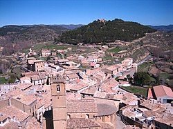
Uncastillo (Aragonese: Uncastiello) is a municipality in the province of Zaragoza, Aragon, eastern Spain. At the 2010 census, [2] it had a population of 781.
Contents
Along with Sos d'o Rei Catolico, Exeya d'os Caballers, Sádaba and Tauste, Uncastillo is one of the five towns comprising the comarca of Cinco Villas.
In 1966, Uncastillo was declared a Conjunto Histórico-Artístico. It has several Romanesque buildings, including the parish churches of St. Martin and Santa Maria and the churches of San Felices, San Andrés and San Juan. Its other landmarks include the castle and palace of Peter IV (14th century).