
Skamania County is a county located in the U.S. state of Washington. As of the 2020 census, the population was 12,036. The county seat and largest incorporated city is Stevenson, although the Carson River Valley CDP is more populous. Skamania County is included in the Portland-Vancouver-Hillsboro, OR-WA Metropolitan Statistical Area.

Cascade Locks is a city in Hood River County, Oregon, United States. The city got its name from a set of locks built to improve navigation past the Cascades Rapids of the Columbia River. The U.S. federal government approved the plan for the locks in 1875, construction began in 1878, and the locks were completed on November 5, 1896. The locks were subsequently submerged in 1938, replaced by Bonneville Lock and Dam, although the city did not lose land from the expansion of Lake Bonneville behind the dam some 4 miles (6 km) downstream of the city. The city population was 1,144 at the 2010 census.

Chinookan peoples include several groups of Indigenous people of the Pacific Northwest in the United States who speak the Chinookan languages. Since at least 4000 BCE Chinookan peoples have resided along the Lower and Middle Columbia River (Wimahl) from the river's gorge downstream (west) to the river's mouth, and along adjacent portions of the coasts, from Tillamook Head of present-day Oregon in the south, north to Willapa Bay in southwest Washington. In 1805 the Lewis and Clark Expedition encountered the Chinook Tribe on the lower Columbia.

The Sandy River is a 56-mile (90 km) tributary of the Columbia River in northwestern Oregon in the United States. The Sandy joins the Columbia about 14 miles (23 km) upstream of Portland.

The Lewis River is a tributary of the Columbia River, about 95 miles (153 km) long, in southwestern Washington in the United States. It drains part of the Cascade Range north of the Columbia River. The drainage basin of the Lewis River covers about 1,046 square miles (2,709 km2). The river's mean annual discharge is about 6,125 cubic feet per second (173.4 m3/s). Unlike nearby Lewis County and Fort Lewis the Lewis River was not named for Meriwether Lewis, but rather for A. Lee Lewis, an early colonizer who homesteaded near the mouth of the river.

Carson is a small census-designated place in the Columbia River Gorge National Scenic Area, north of the Columbia River in Skamania County, in the southwestern part of Washington, United States.

State Route 14 (SR 14) is a 180.66-mile-long (290.74 km) state highway in the U.S. state of Washington. The highway travels east-west on the north side of the Columbia River, opposite Interstate 84 (I-84) to the south in Oregon. SR 14 forms a section of the Lewis and Clark Trail Scenic Byway and begins at an interchange with I-5 in Vancouver. The highway travels east as a four-lane freeway through Camas and Washougal and intersects I-205. SR 14 continues east as a two-lane highway through Clark, Skamania, Klickitat, and Benton counties before it ends at an interchange with I-82 and U.S. Route 395 (US 395) near Plymouth.

The Klickitat are a Native American tribe of the Pacific Northwest. Today most Klickitat are enrolled in the federally recognized Confederated Tribes and Bands of the Yakama Nation, some are also part of the Confederated Tribes of the Grand Ronde Community of Oregon.

The White Salmon River is a 44-mile (71 km) tributary of the Columbia River in the U.S. state of Washington. Originating on the slopes of Mount Adams, it flows into the Columbia Gorge near the community of Underwood. Parts of the river have been designated Wild and Scenic. The principal tributaries of the White Salmon River include Trout Lake and Buck, Mill, Dry, Gilmer, and Rattlesnake Creeks.

The Columbia Gorge AVA is an American Viticultural Area which includes land surrounding the Columbia River Gorge, straddling the border between Oregon and Washington. Due to the significant gradations of climate and geography found in the gorge, this AVA exhibits a wide range of terroir in a relatively small region; it is marketed as a "world of wine in 40 miles".
Husum is an unincorporated community in the White Salmon River Valley in the state of Washington.

Skamania is a small unincorporated community in Skamania County in the southwestern part of the U.S. state of Washington.

State Route 141 (SR 141) is a state highway in Klickitat County, Washington, United States. It runs north–south for 29 miles (47 km), connecting SR 14 in Bingen to White Salmon and Trout Lake. The highway follows the White Salmon River towards the base of Mount Adams, terminating at the Skamania County border at the entrance to the Gifford Pinchot National Forest, where it becomes Forest Road 24. SR 141 is a state scenic highway that provides access to recreation areas on the south side of Mount Adams.

The Little White Salmon River is a tributary, about 19 miles (31 km) long, of the Columbia River in the U.S. state of Washington. Its headwaters are in the Monte Cristo Range in Gifford Pinchot National Forest. The river flows from this part of the Cascade Range into Drano Lake, an arm of the Bonneville Pool of the Columbia. The river drains a basin of 136 square miles (350 km2) The basin's population was an estimated 513 in 2000.
Dodson is an unincorporated community in Multnomah County, Oregon, United States. It is located about 4½ miles (7.2 km) east of Multnomah Falls and one mile west of Warrendale, in the Columbia River Gorge on Interstate 84/U.S. Route 30. It is across the Columbia River from Skamania, Washington. Dodson is within the Cascade Locks ZIP code.
Home Valley is an unincorporated community in the Columbia River Gorge National Scenic Area along the Columbia River in Skamania County, Washington, United States. The community is located on Washington State Route 14 and lies southeast of nearby Carson.
Prindle is an unincorporated community located within the Columbia River Gorge National Scenic Area along the Columbia River in Skamania County, Washington, United States. The community is located on Washington State Route 14 and lies between Washougal to the west and Skamania to the east.
Willard is a small unincorporated community in Skamania County, in southwestern Washington.
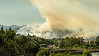
The Tunnel Five Fire or Tunnel 5 Fire was a wildfire in Skamania County, Washington in the Columbia River Gorge, near the border with Oregon. Ignited in the morning of July 2, 2023, the cause of the fire is still under investigation. By July 10, the fire was 80% contained, and by the following day it reached 100% containment.


