Willard, Washington | |
|---|---|
 Willard, Washington | |
| Coordinates: 45°46′51″N121°37′51″W / 45.78083°N 121.63083°W | |
| Country | United States |
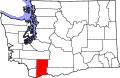
| State | Washington |
| County | Skamania |
| Elevation | 1,253 ft (382 m) |
| Time zone | UTC-8 (Pacific (PST)) |
| • Summer (DST) | UTC-7 (PDT) |
| ZIP code | 98605 |
| Area code | 509 |
| GNIS feature ID | 1528164 [1] |
Willard is a small unincorporated community in Skamania County, in southwestern Washington. [1]
Willard is situated along the Little White Salmon River, 5.0-mile (8.0 km) north of the Columbia River and Washington State Route 14, at the southern boundary of the Gifford Pinchot National Forest. The community of Mill A and the Willard National Fish Hatchery is also situated on the river, just outside of the town. [2]