Related Research Articles

Lake of the Woods County is a county in the northwestern part of the U.S. state of Minnesota. As of the 2020 United States Census, the population was 3,763, making it the second-least populous county in Minnesota. Its county seat is Baudette.
East Koochiching is an unorganized territory in Koochiching County, Minnesota, United States. The population was 383 at the 2000 census.

Northern Manitoba is a geographic and cultural region of the Canadian province of Manitoba. Originally encompassing a small square around the Red River Colony, the province was extended north to the 60th parallel in 1912. The region's specific boundaries vary, as "northern" communities are considered to share certain social and geographic characteristics, regardless of latitude.

Parkland is an informal geographic region of the Canadian province of Manitoba, located between Lakes Manitoba and Winnipegosis on the east and the Manitoba–Saskatchewan border on the west.

Eastern Manitoba, or the Eastman Region, is an informal geographic region of the Canadian province of Manitoba. It is bounded on the north by the Winnipeg River and Lake Winnipeg, on the east by the Manitoba-Ontario border, on the south by the Canada–US border, and on the west by the Red River.

St. Theresa Point First Nation is a First Nations community in northern Manitoba. It has 3 reserves in total, the largest and most populated of which is St. Theresa Point, which is bordered by the unorganized portion of Division No. 22, Manitoba, and by the Wasagamack First Nation.

The Rural Municipality of Piney is a rural municipality in southeastern Manitoba, Canada, along the border with Minnesota in the United States.

Division No. 19, also informally known as North East Manitoba, is a census division within the Province of Manitoba, Canada. Unlike in some other provinces, census divisions do not reflect the organization of local government in Manitoba. These areas exist solely for the purposes of statistical analysis and presentation; they have no government of their own.
Division No. 21, also informally known as Flin Flon-Northwest, is a census division within the Province of Manitoba, Canada. Unlike in some other provinces, census divisions do not reflect the organization of local government in Manitoba. These areas exist solely for the purposes of statistical analysis and presentation; they have no government of their own.
Division No. 22, also informally known as Thompson-North Central, is a census division within the Province of Manitoba, Canada. Unlike in some other provinces, census divisions do not reflect the organization of local government in Manitoba. These areas exist solely for the purposes of statistical analysis and presentation; they have no government of their own.
Buffalo Point First Nation is an Ojibwa or Saulteaux First Nations located in the southeastern corner of Manitoba, along the shores of Lake of the Woods. It is bordered largely by the unorganized portion of Division No. 1, Manitoba, and also has smaller borders with the Rural Municipality of Piney, as well as the northeast corner of Roseau County, Minnesota.

Division No. 1 is a census division located within the Eastman Region of the Canadian province of Manitoba. Unlike in some other provinces, census divisions do not reflect the organization of local government in Manitoba. These areas exist solely for the purposes of statistical analysis and presentation; they have no government of their own.
Census Division No. 8 is a census division located within the Central Plains Region of the Province of Manitoba, Canada. Unlike in some other provinces, census divisions do not reflect the organization of local government in Manitoba. These areas exist solely for the purposes of statistical analysis and presentation; they have no government of their own.
Census Division No. 23 is a census division located within the Northern Region of the Province of Manitoba, Canada. Unlike in some other provinces, census divisions do not reflect the organization of local government in Manitoba. These areas exist solely for the purposes of statistical analysis and presentation; they have no government of their own.
Census Division No. 20 is a census division located within the Parkland Region of the province of Manitoba. Unlike in some other provinces, census divisions do not reflect the organization of local government in Manitoba. These areas exist solely for the purposes of statistical analysis and presentation; they have no government of their own.
Census Division No. 17 (Dauphin) is a census division located within the Parklands Region of the province of Manitoba, Canada. Unlike in some other provinces, census divisions do not reflect the organization of local government in Manitoba. These areas exist solely for the purposes of statistical analysis and presentation; they have no government of their own.
Division No. 1, Unorganized, or Whiteshell Unorganized, is a Statistics Canada census subdivision of its Division No. 1, Manitoba that consists of a part of the division that is not organized into either incorporated municipalities or Indian reserves. Unlike in some other provinces, census divisions do not reflect the organization of local government in Manitoba.
Manitoba's Swan-Pelican Provincial Forest lies just west of Lake Winnipegosis, and is named for the two smaller lakes in the area, Swan Lake and Pelican Lake. The forest has an area of 3,705 km2, and is the second-largest provincial forest in Manitoba. Most of the forest is located within the unorganized portion of Census Division No. 19, but its southernmost reaches extend into the Rural Municipality of Mountain (South). A fairly newly established forest, it was not officially recognized as a provincial forest until 1987.
Division No. 19, Unorganized, or Lake Winnipeg Unorganized, is an unorganized area spanning central Manitoba from east to west, and contains all of Division No. 19 except for First Nations reserves. Unlike in some other provinces, census divisions do not reflect the organization of local government in Manitoba. These areas exist solely for the purposes of statistical analysis and presentation; they have no government of their own.
Division No. 21, Unorganized, or Flin Flon–Snow Lake–Kelsey Unorganized, is an unorganized area in northwestern Manitoba. It consists of all of Division No. 21 excluding municipalities and reserves. Unlike in some other provinces, census divisions do not reflect the organization of local government in Manitoba. These areas exist solely for the purposes of statistical analysis and presentation; they have no government of their own.
References
- ↑ mob-rule. "County lines over OpenStreetMap data" . Retrieved 21 December 2021.
- ↑ "Census Profile, Division No. 22, Unorganized". Statistics Canada . Retrieved 17 October 2017.
Places adjacent to Unorganized Division No. 22, Manitoba | |
|---|---|
| Cities | 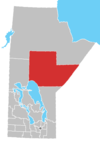 | |
|---|---|---|
| Local government districts | ||
| First Nations | ||
| Indian reserves | ||
| Indian settlements | ||
| Unorganized areas | ||
| Unincorporated communities | ||
| | This Manitoba-related article is a stub. You can help Wikipedia by expanding it. |