Vizianagaram district is one of the six districts in the Uttarandhra region of the Indian state of Andhra Pradesh with its headquarters located at Vizianagaram. The district was once the part of ancient Kalinga.Saripilli Dibbilingeswara temple, Jayathi Mallikarjuna Temple are the finest examples of ancient Eastern Ganga Dynasty built monuments in the district. The district is bounded on the east by the district of Srikakulam, north by Parvathipuram Manyam south by Visakhapatnam, Anakapalli, southeast by the Bay of Bengal, and west by Alluri Sitharama Raju district. It was formed on 1 June 1979, with some parts carved from the neighbouring districts of Srikakulam and Visakhapatnam. The district is named after the princely state of Vizianagaram. In 2011, it was the least populous district in Andhra Pradesh.

Srikakulam district is one of the twenty-six districts of the Indian state of Andhra Pradesh, located in the Uttarandhra region of the state, with its headquarters located at Srikakulam. It is one of the six districts, located in the extreme northeastern direction of the state. It was formerly known as Chicacole, and was under Ganjam district till 1936 April 1, then merged under Vizagapatam district. Srikakulam district forms the core area of Kalinga where most of its historical capitals like Kalinganagari, pithunda, Dantapuram are located.

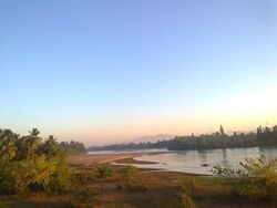
The River Nagavali also known as Langulya is one of the main rivers of Southern Odisha and Andhra States in India, between Rushikulya and Godavari basins.

Sangam is a village and a pilgrimage site in Vangara mandal in Srikakulam district in the state of Andhra Pradesh, India. Sangam is a village and a pilgrimage site in Vangara mandal in Srikakulam district in the state of Andhra Pradesh, India.
Pusapatirega is a village and mandal in Vizianagaram district of the Indian state of Andhra Pradesh, India.
Dattirajeru is a village in Dattirajeru mandal in Vizianagaram district of the Indian state of Andhra Pradesh, India.

Pathapatnam is a town in Srikakulam district of the Indian state of Andhra Pradesh. It is located in Pathapatnam mandal of Palakonda revenue division. Pathapatnam is located on the border of Srikakulam district of Andhra Pradesh and Gajapati district of Odisha. Parlakhemundi, the headquarters of Gajapati District, can be considered as twin town of Pathapatnam because of its close proximity. It is located around 65 km from srikakulam. It was the old capital of Paralakhemundi Gajapati Maharajah of his erstwhile kingdom.
Vajrapu-kotturu is a village in Srikakulam district of the Indian state of Andhra Pradesh. Vajrapukotturu mandal is bordered by Mandasa, Palasa, Nandigam and Santha Bommali mandals of Srikakulam district and has a long coastline off Bay of Bengal. Bendi Gedda river joins the sea after forming a lagoon in this mandal area.
Atchutapuram is a mandal in Anakapalli district, in the Indian state of Andhra Pradesh.
Golugonda is a village and a Mandal in Anakapalli district in the state of Andhra Pradesh in India. This village is famous for availability of semi-precious stones. Special police squads have been formed to prevent illegal quarrying of semi-precious stones both here and in other mandals in the district.

Rambilli is a village and a Mandal in Anakapalli district in the state of Andhra Pradesh in India. There is a famous Lord Shiva Temple "Sri Dharalingeswara Swamy Temple" in Rambilli mandal at Panchadaarla in Dharapalem village It is also the site of INS Varsha, an upcoming Indian Navy base.
Ravikamatham is a village and mandal headquarters of Ravikamatham mandal in Anakapalli district in the state of Andhra Pradesh in India.

Sabbavaram is a village and mandal Headquarters of Sabbavaram Mandal in Anakapalli district in the state of Andhra Pradesh in India.
Ambajipet mandal is one of the 22 mandals in Dr. B.R. Ambedkar Konaseema district of the Indian state of Andhra Pradesh.

Duggirala mandal is one of the 18 mandals in Guntur district of the Indian state of Andhra Pradesh. It is under the administration of Tenali revenue division and the headquarters are located at Duggirala. The mandal is bounded by Mangalagiri, Pedakakani, Tenali and Kollipara mandals. Krishna River lies to the northeast of the Duggirala mandal.
Kollur mandal is one of the 25 mandals in Bapatla district of the Indian state of Andhra Pradesh. It is under the administration of Tenali revenue division and the headquarters are located at Kollur.

Thullur mandal is one of the 18 mandals in Guntur district of the Indian state of Andhra Pradesh. It is under the administration of Guntur Revenue Division and the headquarters are located at Thullur. The mandal is situated on the banks of Krishna River, bounded by Amaravathi, Tadikonda, Tadepalle and Mangalagiri mandals. The mandal is also a part of the new capital city of Andhra Pradesh to be developed. 18 villages from the mandal fall under the jurisdiction of Andhra Pradesh Capital City.
Bhattiprolu mandal is one of the 25 mandals in Bapatla district of the Indian state of Andhra Pradesh. It is under the administration of Tenali revenue division and the headquarters are located at Bhattiprolu. The mandal is situated on the banks of Krishna River, bounded by Kollur, Vemuru, Cherukupalle, Nagaram and Repalle mandals. The mandal headquarters ten villages are included in Andhra Pradesh Capital Region.

Guntur West mandal is one of the 18 mandals in Guntur district of the Indian state of Andhra Pradesh. It is under the administration of Guntur revenue division and was formed by bifurcating Guntur urban mandal into Guntur East and Guntur West, with its headquarters at Guntur.
The I. Polavaram mandal is one of the 22 mandals in Dr. B.R. Ambedkar Konaseema district of Andhra Pradesh. As per census 2011, there are 11 villages in this mandal.