
Srikakulam district is one of the twenty-six districts of the Indian state of Andhra Pradesh, located in the Uttarandhra region of the state, with its headquarters located at Srikakulam. It is one of the six districts, located in the extreme northeastern direction of the state. It was formerly known as Chicacole, and was under Ganjam district till 1 April 1936, then merged under Vizagapatam district. Srikakulam district forms the core area of Kalinga where most of its historical capitals like Kalinganagari, pithunda, Dantapuram are located.

Parvathipuram is a municipality located at Parvathipuram Manyam district of Indian state of Andhra Pradesh. It is the administrative headquarters of Parvathipuram Manyam district and headquarters of Parvathipuram revenue division and Parvathipuram mandal. This revenue division shares a border with various districts in Odisha.
Kankipadu is a village in Krishna District of the Indian state of Andhra Pradesh. It is also the mandal headquarters of Kankipadu mandal in Vuyyuru revenue division.

Avanigadda is a town in Krishna district of the Indian state of Andhra Pradesh. It is the mandal headquarters of Avanigadda mandal in Machilipatnam revenue division.
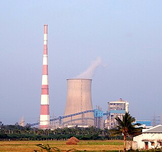
Ibrahimpatnam is a part of Vijayawada in NTR district of the Indian state of Andhra Pradesh. It is also the mandal headquarters of Ibrahimpatnam mandal. The Dr Narla Tata Rao Thermal Power Station, one of the major thermal power stations of the state, is located near the town. The Railway Wagon Workshop at Rayanapadu is also located very near to Ibrahimpatnam at a distance of 4 km.

Gara is a village in Srikakulam district of the Indian state of Andhra Pradesh. It is also the mandal head quarters of Gara Mandal, Srikakulam District, AP.
Jalamuru is a village in Srikakulam district of the Indian state of Andhra Pradesh. Jalumuru mandal is bordered by Narasannapeta, Sarubujjili, Saravakota and Kotabommali mandals of Srikakulam district.
Kanchili is a village in Srikakulam district of the Indian state of Andhra Pradesh.
Kotabommali is a mandal in the Srikakulam district of the Indian state of Andhra Pradesh.

Narasannapeta is a census town in Srikakulam district of the Indian state of Andhra Pradesh. It is the mandal headquarters of Narasannapeta mandal in Srikakulam revenue division. 43 villages are there under the administrative division of Narasannapeta.
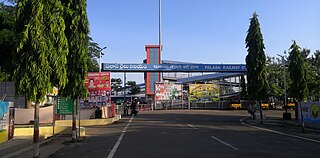
Palasa is one of the twin towns located in the Srikakulam district of Andhra Pradesh, India. The town is situated between Srikakulam and Berhampur. It is categorized as the second grade municipality. Also the town serves as the headquarters of Palasa Mandal.

Pathapatnam is a town in Srikakulam district of the Indian state of Andhra Pradesh. It is located in Pathapatnam mandal of Tekkali revenue division. Telugu is the major spoken language in the town and in entire mandal. Pathapatnam is located on the border of Srikakulam district of Andhra Pradesh and Gajapati district of Odisha. Parlakhemundi, the headquarters of Gajapati District, can be considered as twin town of Pathapatnam because of its close proximity. It is located around 65 km from srikakulam. It was the old capital of Paralakhemundi Gajapati Maharajah of his erstwhile kingdom.
Sarubujjili is a village in Srikakulam district of the Indian state of Andhra Pradesh. Sarubujjili mandal is bordered by Burja, Seethampeta, Hiramandalam, Jalumuru and Narasannapeta mandals of Srikakulam district.

Tekkali is a census town in Srikakulam district of the Indian state of Andhra Pradesh. It is the mandal headquarters of Tekkali mandal and Tekkali revenue division and is located at a distance of 51 km from the district headquarters.
Tilaru is a village located in Kotabommali mandal in Srikakulam district, Andhra Pradesh, India.
Harichandapuram is an Indian village and panchayat, located in Kotabommali mandal in Srikakulam district, Andhra Pradesh, India.

Kollipara is a village in Guntur district of the Indian state of Andhra Pradesh. It is the headquarters of Kollipara mandal in Tenali revenue division. And it was one of the capital for Pericchedi.
Komarthi is a Panchayat village in Narasannapeta mandal of Srikakulam district in the Indian state of Andhra Pradesh. Postal Index Number of this village is 532421.
Kondapaturu is a village in Kakumanu Mandal in the Guntur District of Andhra Pradesh, India. It is located 35 km (22 mi) south of the main district of Guntur, 3 km (1.9 mi) from Kakumanu, and 296 km (184 mi) from Hyderabad, the state capital. Between March and April, Thirunalla is celebrated by 200,000 to 300,000 visiting worshippers every year. According to tradition of Bhavanarayana temple situated in Bapatla The Consort of the lord Bhavanarayana Belongs to Kondapaturu village.to signify this fact from over 1490 years traditional Puttinti sare sent to Lord Bhavanarayana during his annual Kalyanostavam.
Jarjangi is a Panchayath village in Kotabommali mandal, Srikakulam district, in the Indian state of Andhra Pradesh. The Postal Index Code of this village is 532195.


