Related Research Articles

Vizianagaram is a city and the headquarters of Vizianagaram district in the Indian state of Andhra Pradesh. It is central Eastern Ghats, about 24 km (15 mi) west of the Bay of Bengal and 40 km (25 mi) north-northeast of Visakhapatnam. The city has a population of 2,28,025 and was the headquarters of the rajas of Vizianagaram, who played a notable role in the history of Andhra Pradesh in the 18th century and were patrons of education and the fine arts.

Srikakulam district is one of the nine districts in the Coastal Andhra region of the Indian state of Andhra Pradesh, with its headquarters located at Srikakulam. It is one of the nine coastal districts, located in the extreme northeastern direction of the state. It was formerly known as Chicacole.
Amadalavalasa is a town in Srikakulam district of the Indian state of Andhra Pradesh. It is a municipality and also the mandal headquarters of Amadalavalasa mandal. The town is spread over an area of 19.65 km2 (7.59 sq mi), which is under the jurisdiction of Visakhapatnam Metropolitan Region Development Authority. Srikakulam Road railway station is situated at Amadalavalasa.

Rajam is a town in Srikakulam district of the Indian state of Andhra Pradesh. It is a nagar panchayat and the headquarters of Rajam mandal. It is situated at a distance of 40 Kms from the district headquarters. The place has nostalgic association with Thandra Paparaya, the valiant Sardar of Bobbili and who is credited with slaying of Vijayaramaraju, the Maharaja of Vijayanagaram at the end of the battle of Bobbili in 1757.

The River Nagavali also known as Langulya is one of the main rivers of Southern Odisha and Northern Andhra Pradesh States in India, between Rushikulya and Godavari basins.
Burja or Boorja is a village in Srikakulam district of the Indian state of Andhra Pradesh. Burja is located near River Nagavali.

Gara is a village in Srikakulam district of the Indian state of Andhra Pradesh. It is also the mandal head quarters of Gara Mandal, Srikakulam District, AP.

Hiramandalam is a census town in Srikakulam district of the Indian state of Andhra Pradesh. It is also the mandal headquarters of Hiramandalam mandal in Palakonda revenue division. BRR Project Located at Hiramandalam town. It is located 49 km towards North from District headquarters Srikakulam.
Jalamuru is a village in Srikakulam district of the Indian state of Andhra Pradesh. Jalumuru mandal is bordered by Narasannapeta, Sarubujjili, Saravakota and Kotabommali mandals of Srikakulam district.
Kotturu is a village in Srikakulam district of the Indian state of Andhra Pradesh. It is located in Kothuru mandal of Palakonda revenue division.
Nandigam is a village near major town Palasa in Srikakulam district of the Indian state of Andhra Pradesh. It is located in Nandigam mandal.

Narasannapeta is a census town in Srikakulam district of the Indian state of Andhra Pradesh. It is the mandal headquarters of Narasannapeta mandal in Srikakulam revenue division. 43 villages are there under the administrative division of Narasannapeta.

Palakonda is a town in Srikakulam district of the Indian state of Andhra Pradesh. It is a nagar panchayat and the mandal headquarters of Palakonda mandal in Palakonda revenue division
Pathapatnam is a town in Srikakulam district of the Indian state of Andhra Pradesh. It is located in Pathapatnam mandal of Palakonda revenue division. Pathapatnam is located on the border of Srikakulam district of Andhra Pradesh and Gajapati district of Odisha. Parlakhemundi, the headquarters of Gajapati District, can be considered as twin town of Pathapatnam because of its close proximity. It is located around 65 km from srikakulam.
Santhabommali is a village in Srikakulam district of the Indian state of Andhra Pradesh.
Saravakota is a village in Srikakulam district of the Indian state of Andhra Pradesh. It is located in Saravakota mandal of Palakonda revenue division.
Sarubujjili is a village in Srikakulam district of the Indian state of Andhra Pradesh. Sarubujjili mandal is bordered by Burja, Seethampeta, Hiramandalam, Jalumuru and Narasannapeta mandals of Srikakulam district.
Tekkali is a census town in Srikakulam district of the Indian state of Andhra Pradesh. It is the mandal headquarters of Tekkali mandal in Tekkali revenue division and is located at a distance of 51 KMs from the district headquarters. The prominent actor Nandhamuri Taraka RamaRao represented this assembly constituency in AndhraPradesh General Legislative assembly Elections 1994.
Vajrapu-kotturu is a village in Srikakulam district of the Indian state of Andhra Pradesh. Vajrapukotturu mandal is bordered by Mandasa, Palasa, Nandigam and Santha Bommali mandals of Srikakulam district and has a long coastline off Bay of Bengal. Bendi Gedda river joins the sea after forming a lagoon in this mandal area.
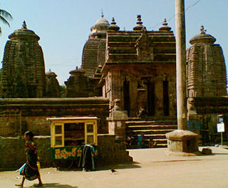
Mukhalingam is a village panchayat in Srikakulam district of Andhra Pradesh, India. It was the erstwhile capital of the Eastern Ganga dynasty. It is home to a group of three Śiva temples - Madhukeswara, Someswara, Bhimeswara - which have been variously dated by historians from late eighth century to early eleventh century CE. The village is located on the left bank of Vamsadhara river at a distance of 48 kms from Srikakulam town.
References
- ↑ "New 'AP 39' code to register vehicles in Andhra Pradesh launched". The New Indian Express. Vijayawada. 31 January 2019. Retrieved 9 June 2019.
- ↑ "Mandal wise list of villages in Srikakulam district" (PDF). Chief Commissioner of Land Administration. National Informatics Centre. Archived from the original (PDF) on 8 December 2014. Retrieved 6 March 2016.
Coordinates: 18°36′59″N83°57′44″E / 18.61639°N 83.96222°E
| This article about a location in Srikakulam district, Andhra Pradesh is a stub. You can help Wikipedia by expanding it. |