Vann Crossroads, North Carolina

Last updated

Vann Crossroads, North Carolina
CDP
USA North Carolina location map.svg
Red pog.svg
Vann Crossroads, North Carolina
Location within the state of North Carolina
Coordinates: 35°10′11″N78°24′10″W / 35.16972°N 78.40278°W / 35.16972; -78.40278
Country United States
State North Carolina
County Sampson
Area
[1]
  Total4.57 sq mi (11.83 km2)
  Land4.56 sq mi (11.81 km2)
  Water0.01 sq mi (0.02 km2)
Elevation
[2]
184 ft (56 m)
Population
 (2020)
  Total306
  Density67.11/sq mi (25.91/km2)
Time zone UTC-5 (Eastern (EST))
  Summer (DST) UTC-4 (EDT)
FIPS code 37-69755 [3]
GNIS feature ID2402963 [2]

Vann Crossroads is a census-designated place (CDP) in Sampson County, North Carolina, United States. The population was 306 at the 2020 census.

Contents

Geography

According to the United States Census Bureau, the CDP has a total area of 4.6 square miles (12 km2), of which 4.6 square miles (11.9 km2) is land and 0.22% is water.

Demographics

Historical population
CensusPop.Note
2020 306
U.S. Decennial Census [4]

As of the census [3] of 2000, there were 324 people, 127 households, and 100 families residing in the CDP. The population density was 70.7 inhabitants per square mile (27.3/km2). There were 141 housing units at an average density of 30.8 per square mile (11.9/km2). The racial makeup of the CDP was 87.96% White, 11.11% African American and 0.93% Native American. Hispanic or Latino of any race were 0.62% of the population.

There were 127 households, out of which 31.5% had children under the age of 18 living with them, 66.1% were married couples living together, 10.2% had a female householder with no husband present, and 20.5% were non-families. 16.5% of all households were made up of individuals, and 9.4% had someone living alone who was 65 years of age or older. The average household size was 2.55 and the average family size was 2.86.

In the CDP, the population was spread out, with 23.8% under the age of 18, 5.6% from 18 to 24, 25.6% from 25 to 44, 27.5% from 45 to 64, and 17.6% who were 65 years of age or older. The median age was 41 years. For every 100 females, there were 94.0 males. For every 100 females age 18 and over, there were 93.0 males.

The median income for a household in the CDP was $32,443, and the median income for a family was $38,036. Males had a median income of $27,000 versus $22,426 for females. The per capita income for the CDP was $16,881. About 6.1% of families and 8.4% of the population were below the poverty line, including 13.2% of those under age 18 and 7.9% of those age 65 or over.

Related Research Articles

<span class="mw-page-title-main">Moores Mill, Alabama</span> Census-designated place in Alabama, United States

Moores Mill is an unincorporated community and census-designated place (CDP) in Madison County, Alabama, United States, and is included in the Huntsville-Decatur Combined Statistical Area. The population was 6,729 at the 2020 census, up from 5,682 at the 2010 census.

<span class="mw-page-title-main">Bayview-Montalvin, California</span> Former CDP in California, United States

Bayview-Montalvin is a former census-designated place (CDP) in Contra Costa County, California, United States. The population was 5,004 at the 2000 census.

<span class="mw-page-title-main">Day Valley, California</span> Census-designated place in California, United States

Day Valley is a census-designated place (CDP) in Santa Cruz County, California, United States. The population was 3,409 at the 2010 census.

<span class="mw-page-title-main">Long Hill, Groton, Connecticut</span> Census-designated place in Connecticut, United States

Long Hill is a census-designated place (CDP) in the town of Groton in New London County, Connecticut, United States. The population was 4,205 at the 2010 census.

<span class="mw-page-title-main">Fallston, Maryland</span> Census-designated place in Maryland, United States

Fallston is a census-designated place (CDP) in Harford County, Maryland, United States. The population was 8,958 at the 2010 census, up from 8,427 in 2000. Fallston is a semi-rural community consisting mostly of farms and suburban-like developments.

<span class="mw-page-title-main">Wilson-Conococheague, Maryland</span> CDP in Maryland, United States

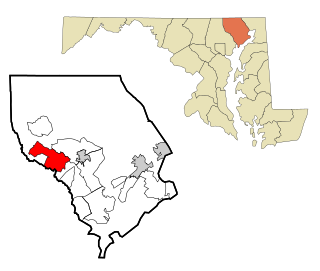
Wilson-Conococheague is a census-designated place (CDP) in Washington County, Maryland, United States. The population was 2,262 at the 2020 census.

<span class="mw-page-title-main">Cherry Grove, Ohio</span> Census-designated place in Ohio, United States

Cherry Grove is a census-designated place (CDP) in Anderson Township, Hamilton County, Ohio, United States. The population was 4,419 at the 2020 census.

<span class="mw-page-title-main">Dry Run, Ohio</span> Census-designated place in Ohio, United States

Dry Run is a census-designated place (CDP) in Hamilton County, Ohio, United States. The population was 7,672 at the 2020 census.

<span class="mw-page-title-main">Grandview, Hamilton County, Ohio</span> Census-designated place in Ohio, United States

Grandview is a census-designated place (CDP) in Hamilton County, Ohio, United States. The population was 1,312 at the 2020 census.

<span class="mw-page-title-main">Northbrook, Ohio</span> Census-designated place in Ohio, United States

Northbrook is a census-designated place (CDP) in Hamilton County, Ohio, United States. The population was 10,912 at the 2020 census.

<span class="mw-page-title-main">Northgate, Ohio</span> Census-designated place in Ohio, United States

Northgate is a census-designated place (CDP) in Colerain Township, Hamilton County, Ohio, United States. The population was 7,277 at the 2020 census.

<span class="mw-page-title-main">Turpin Hills, Ohio</span> Census-designated place in Ohio, United States

Turpin Hills is a census-designated place (CDP) in Anderson Township, Hamilton County, Ohio, United States. The population was 5,162 at the 2020 census.

<span class="mw-page-title-main">White Oak, Ohio</span> Census-designated place in Ohio, United States

White Oak is a census-designated place (CDP) in Hamilton County, Ohio, United States. It is seven miles northwest of Cincinnati. The population was 19,541 at the 2020 census. White Oak is situated in both Green Township and Colerain Township.

<span class="mw-page-title-main">Five Points, Warren County, Ohio</span> CDP in Ohio, United States

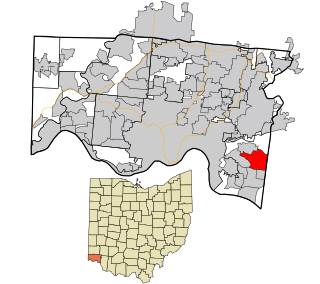
Five Points is a census-designated place (CDP) in Clearcreek Township, Warren County, Ohio, United States. The population was 2,247 at the 2020 census.

<span class="mw-page-title-main">Glide, Oregon</span> Census-designated place in Oregon, United States

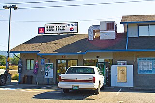
Glide is a census-designated place (CDP) in Douglas County, Oregon, United States. The population was 1,795 at the 2010 census.

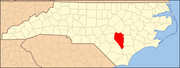
Harrison is a census-designated place (CDP) in Hamilton County, Tennessee, United States. The population was 7,902 at the 2020 census. It is part of the Chattanooga metropolitan area. Harrison Bay State Park, the Hamilton County Landfill, Bear Trace Golf Course, a course designed by Jack Nicklaus, and Skull Island, a recreational area owned by TVA, are all located in Harrison.

<span class="mw-page-title-main">Woods Creek, Washington</span> CDP in Washington, United States

Woods Creek is a census-designated place (CDP) in Snohomish County, Washington, United States. The population was 5,589 at the 2010 census.

<span class="mw-page-title-main">Piney View, West Virginia</span> Census-designated place in West Virginia, United States

Piney View is a census-designated place (CDP) in Raleigh County, West Virginia, United States. The population was 989 at the 2010 census.

Howland is a census-designated place (CDP) in Penobscot County, Maine, United States. The population was 1,096 at the 2010 census.

Lincoln is a census-designated place (CDP) consisting of the primary settlement in the town of Lincoln in Penobscot County, Maine, United States. The population was 2,884 at the 2010 census.

References

  1. "ArcGIS REST Services Directory". United States Census Bureau. Retrieved September 20, 2022.
  2. 1 2 U.S. Geological Survey Geographic Names Information System: Vann Crossroads, North Carolina
  3. 1 2 "U.S. Census website". United States Census Bureau . Retrieved January 31, 2008.
  4. "Census of Population and Housing". Census.gov. Retrieved June 4, 2016.