
The Australian plate is a major tectonic plate in the eastern and, largely, southern hemispheres. Originally a part of the ancient continent of Gondwana, Australia remained connected to India and Antarctica until approximately 100 million years ago when India broke away and began moving north. Australia and Antarctica had begun rifting by 96 million years ago and completely separated a while after this, some believing as recently as 45 million years ago, but most accepting presently that this had occurred by 60 million years ago.

Hunter Island and Matthew Island are two small and uninhabited volcanic islands in the South Pacific, located 300 kilometres (190 mi) east of New Caledonia and south-east of Vanuatu archipelago. Hunter Island and Matthew Island, 70 km (43 mi) apart, are claimed by Vanuatu as part of Tafea Province, and considered by the people of Aneityum part of their custom ownership, and as of 2007 were claimed by France as part of New Caledonia.

The 1,600 kilometres (990 mi) long Macquarie Fault Zone is a major right lateral-moving transform fault along the seafloor of the south Pacific Ocean which runs from New Zealand southwestward towards the Macquarie triple junction. It is also the tectonic plate boundary between the Australian plate to the northwest and the Pacific plate to the southeast. As such it is a region of high seismic activity and recorded the largest strike-slip event on record up to 23 May 1989, of at least 8.0

The New Hebrides plate, sometimes called the Neo-Hebridean plate, is a minor tectonic plate located in the Pacific Ocean. While most of it is submerged as the sea bottom of the North Fiji Basin, the island country of Vanuatu, with multiple arc volcanoes, is on the western edge of the plate. It is bounded on the south-west by the Australian plate, which is subducting below it at the New Hebrides Trench. The Vanuatu subduction zone is seismically active, producing many earthquakes of magnitude 7 or higher. To its north is the Pacific plate, north-east the Balmoral Reef plate and to its east the Conway Reef plate.

The Balmoral Reef plate is a small tectonic plate (microplate) located in the south Pacific north of Fiji. Clockwise from the north, it borders the Pacific plate, the Australian plate, Conway Reef plate, and the New Hebrides plate. The northern and western borders are a divergent boundary while the rest of the borders are transform and convergent boundaries. The Balmoral Reef plate's ocean crust is less than 12 million years old and is spreading between the New Hebrides and Tonga subduction. The plate forms the west central part of the seafloor of the North Fiji Basin.

Located in the western Pacific Ocean near Indonesia, the Molucca Sea plate has been classified by scientists as a fully subducted microplate that is part of the Molucca Sea Collision Complex. The Molucca Sea plate represents the only known example of divergent double subduction (DDS), which describes the subduction on both sides of a single oceanic plate.

The Pacific Ocean evolved in the Mesozoic from the Panthalassic Ocean, which had formed when Rodinia rifted apart around 750 Ma. The first ocean floor which is part of the current Pacific plate began 160 Ma to the west of the central Pacific and subsequently developed into the largest oceanic plate on Earth.
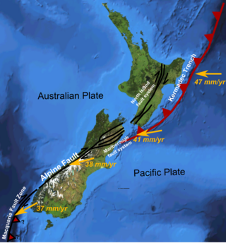
The Hikurangi Margin is New Zealand's largest subduction zone and fault.
The 1999 Ambrym earthquake occurred on November 27 at with a moment magnitude of 7.4 and a maximum Mercalli intensity of VII. The back arc thrust event occurred within the Vanuatu archipelago, just to the south of the volcanic island of Ambrym. Vanuatu, which was previously known as New Hebrides, is subject to volcanic and earthquake activity because it lies on an active and destructive plate boundary called the New Hebrides Subduction Zone. While the National Geophysical Data Center classified the total damage as moderate, a destructive local tsunami did result in some deaths, with at least five killed and up to 100 injured.

The North Fiji Basin (NFB) is an oceanic basin west of Fiji in the south-west Pacific Ocean. It is an actively spreading back-arc basin delimited by the Fiji islands to the east, the inactive Vitiaz Trench to the north, the Vanuatu/New Hebrides island arc to the west, and the Hunter fracture zone to the south. Roughly triangular in shape with its apex located at the northern end of the New Hebrides Arc, the basin is actively spreading southward and is characterised by three spreading centres and an oceanic crust younger than 12 Ma. The opening of the NFB began when a slab roll-back was initiated beneath the New Hebrides and the island arc started its clockwise rotation. The opening of the basin was the result of the collision between the Ontong Java Plateau and the Australian plate along the now inactive Solomon–Vitiaz subduction system north of the NFB. The NFB is the largest and most developed back-arc basin of the south-west Pacific. It is opening in a complex geological setting between two oppositely verging subduction systems, the New Hebrides/Vanuatu and Tonga trenches and hence its ocean floor has the World's largest amount of spreading centres per area.
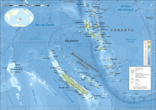
The d'EntrecasteauxRidge (DER) is a double oceanic ridge in the south-west Pacific Ocean, north of New Caledonia and west of Vanuatu Islands. It forms the northern extension of the New Caledonia–Loyalty Islands arc, and is now actively subducting in the Vanuatu subduction zone under the Vanuatu/New Hebrides arc. The subduction of the DER is responsible for the anomalous morphology of the central part of New Hebrides arc whose movement more closely matches the north-east direction of the subducting Australian Plate.
The 2021 Loyalty Islands earthquake was a 7.7 magnitude earthquake that struck offshore between Vanuatu and New Caledonia on February 11, 2021, at 00:19 local time. It is the 4th largest earthquake of 2021.

The 2002 Port Vila earthquake occurred in the early dawn of January 3, 2002, 4:22 a.m. local time (UTC+11) northwest of Port Vila, the capital of Vanuatu. It had a magnitude of 7.2 and a maximum intensity of X (Extreme) west of the island on the Modified Mercalli intensity scale. There are no exact estimates on the number of injured individuals, but the majority of accounts say there were "several" amounts of injured civilians. the event also caused a minor tsunami of about 0.4−0.8 m just 11 minutes after the quake.
The New Hebrides Trench is an oceanic trench which is over 7.1 km (4.4 mi) deep in the Southern Pacific Ocean. It lies to the northeast of New Caledonia and the Loyalty Islands, to the southwest of Vanuatu, east of Australia, and south of Papua New Guinea and the Solomon Islands. The trench was formed as a result of a subduction zone. The Australian plate is being subducted under the New Hebrides plate causing volcanism which produced the Vanuatu archipelago.

The Hunter fracture zone is a sinistral (left-lateral) transform faulting fracture zone, that to its south is part of a triple junction with the New Hebrides Trench, and the North Fiji Basin Central Spreading Ridge. The Hunter fracture zone, with the Hunter Ridge, an area with recent volcanic activity to its north, is the southern boundary of the North Fiji Basin. This boundary area in the south-western part of the Hunter fracture zone is associated with hot subduction, and a unique range of volcanic geochemistry.
The South Fiji Basin is a large 4 to 4.7 km deep oceanic basin in the south-west Pacific Ocean, south of Fiji. It was formed from the then Indo-Australian plate and is delimited to the north west by the New Hebrides Trench, and the Hunter fracture zone, to the west by the Three Kings Ridge, to the east by the Lau-Colville Ridge, and to the south by the continental shelf of Zealandia.
The New Britain subduction zone is one of the most recently formed and most active subduction zones on earth, producing great earthquakes, with potential for tsunami hazard, and being associated with active volcanism, as part of the Pacific Ring of Fire. It has a close relationship to an area of subduction tectonic activity that extends south eastward from New Britain to the Vanuatu subduction zone, involving the north eastern portion of the Australian Plate and its complicated collision dynamics with the south-western portion of the Pacific Plate.
The Hunter Ridge, is an active volcanic arc oceanic ridge located on the oceanic New Hebrides plate in the south-west Pacific Ocean extending at least 550 km (340 mi). It defines the south-western limit of the North Fiji Basin (NFB) and is an area of unique range in volcanic geochemistry, which transpires to have been due partially to a new, previously unrecognised, subduction zone.


