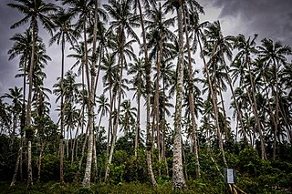
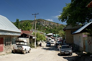
Vanuu (from Sowavan uu "under the noise"), also known as Waterfall Village, is a large settlement on the southwestern coast of Pentecost Island in Vanuatu. The village consists of several scattered groups of houses within an ageing coconut plantation.
Vanuu is located on Pentecost's main north-south road, about 9 kilometres (5.6mi) north of Lonorore Airport and about 8 kilometres (5.0mi) south of Melsisi.
Vanuu has a Churches of Christ church, a nakamal, small stores, and a guesthouse. Children from Vanuu attend the Anglophone primary school at Ranmawot, 2kilometres away. Ranwadi High School is also nearby.
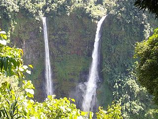
The large waterfall and associated natural swimming pool behind the village, and the presence of good anchorage for yachts, make Vanuu a popular destination for visitors to Pentecost Island. The waterfall behind Vanuu is one of seven major falls along the river; the others are located high in the bush. There is also a limestone cave nearby. Although Vanuu is not located within the area in which land diving is practised, it is sometimes used as a base by tourists who visit Pentecost to witness the ceremony.
History and geography
The flat coastal strip on which Vanuu is built was historically uninhabited and covered with dense cottonwood (burao) trees. The area suffered drastic depopulation in the late 19th and early 20th century following the introduction of European diseases. The present village was founded in the early-mid 20th century by men from other areas of Pentecost, who established a coconut plantation for the production of copra (though this is no longer productive today). Many of their grandchildren (Vanuu's present inhabitants) retain ties to their ancestral villages.
Most villagers maintain gardens in the mountains above Vanuu, growing vegetables such as taro for local consumption and earning income from cash crops such as kava. Fees paid by visitors to the waterfall, and earnings from other tourist-related activities, are also a source of income.
Language and culture
The language and culture of the Vanuu area were historically intermediate between those of Central Pentecost and of South Pentecost, although the influence of the former predominates today.
The area's original language was Sowa, but depopulation in the 20th century led to the extinction of this language. Today Apma (the original language of Central Pentecost to the north) is the village's main language, though village chief Isaiah Tabi Vahka is at the forefront of efforts to document and revive Sowa. The national language Bislama is also spoken, and the village is home to a number of Ske speakers due to intermarriage with the Baravet community to the south. English is also spoken by educated villagers.
Uttara Kannada is a fifth largest district in the Indian state of Karnataka, It is bordered by the state of Goa and Belagavi districts to the north, Dharwad District and Haveri District to the east, Shivamogga District, and Udupi District to the south, and the Laccadive Sea to the west. Karwar is the district headquarters, Kumta and Sirsi are the major commercial centers in the district. The district's agroclimatic divisions include the coastal plain consisting of Karwar, Ankola, Kumta, Honnavar Bhatkal taluks and Malenadu consisting of Sirsi, Siddapur, Yellapur, Haliyal, Dandeli, Joida, Mundgod taluks.
Pentecost is one of the 83 islands that make up the South Pacific nation of Vanuatu.
Baluan Island is the southernmost island of the Admiralty Islands group which makes up the majority of Manus Province in Papua New Guinea. It belongs to the Pam Islands, an island subgroup to the south of Lou Island. It is formed from an extinct volcano, also named Baluan.
Arslanbob is a village, sub district, valley, mountain range, and a large forest of wild walnut in the Jalal-Abad Region of Kyrgyzstan. Kyrgyzstan's first known export to Europe was the Arslanbob walnut. Two waterfalls are located in the area which attract tourists, pilgrims and other visitors during the spring and summer months.
Al Baha is a city in south western Saudi Arabia located in the Sarawat Mountains. It is the capital of Al-Bahah Province, and is one of the Kingdom's prime tourist attractions. It enjoys a pleasant climate and is surrounded by more than forty forests, including Raghdan, Al-Zaraeb and Baidan. Al Baha is the headquarters of the Governor, local councils and branches of governmental departments. Receiving the state's special attention, the city of Al Baha abounds in educational, tourist and health institutions. It is considered the capital of the Ghamdi and Zahrani tribes in Saudi Arabia, and most of its inhabitants are from the native tribes.
Fossbergom is the administrative centre of Lom Municipality in Innlandet county, Norway. The village is located on the south shore of the river Otta, at the north end of the Bøverdal valley. The 1.46-square-kilometre (360-acre) village has a population (2021) of 830 and a population density of 567 inhabitants per square kilometre (1,470/sq mi). Fossbergom is the main population centre for the municipality and a large portion of the residents work in the tourism, commerce, and the service sectors.
Epi is an island in Shefa Province, Vanuatu, at the north end of the Shepherd Islands.
Belladrum is a small community in the Mahaica-Berbice Region of Guyana, on the Atlantic coast, about 15 kilometres (9 mi) east of Mahaicony.
Jampui Hills is a part of the Mizo hills range located in the North Tripura district in the north eastern part of the Indian state of Tripura. The average altitude of the hill range is approximately 1000 metres above sea level.
Konni, also spelt Konny, is a town and taluk headquarters in Pathanamthitta district of Kerala, India. Konni is known for its elephant cages, forests, and rubber plantations. It is also known as "Aanakoodinte Nadu". Nearest town is Pathanamthitta. Konni is located 32 km (20 mi) from Chengannur railway station and NH 183 in Chengannur. It is well-connected via the Muvattupuzha - Punalur state highway.
Ranwadi School is a co-educational boarding school on Pentecost, Vanuatu. The school has over 300 students who come from all over Pentecost Island and from other parts of Vanuatu. Lisepsep inhabit the forests around the school.
Sowa was the original language of south-central Pentecost island in Vanuatu. In the 20th century it was totally displaced by Apma, a neighbouring language. Sowa was closely related to Ske, another south Pentecost language.
The Bolaven Plateau is an elevated region in southern Laos. Most of the plateau is located within Champasak Province of Laos, though the edges of the plateau are also located in Salavan, Sekong and Attapeu Provinces. It is located between the Annamite Range, along which runs Laos' eastern border with Vietnam, and the Mekong River to the west, at about 15°N106°E. The plateau's elevation ranges approximately from 1,000 to 1,350 metres above sea level. The plateau is crossed by several rivers and has many scenic waterfalls. The name Bolaven makes reference to the Laven ethnic group which has historically dominated the region. However, domestic migrations by the Lao ethnic group has resulted in widespread interethnic marriage, thus modifying the ethnic composition of the region.
Talakona is situated in Tirupati district of Andhra Pradesh, India. It is a resort with waterfalls, dense forests and wildlife. Talakona waterfall is in Sri Venkateswara National Park, Tirupati district of Andhra Pradesh. With a 270 feet (82 m)-fall, Talakona is the highest waterfall in Andhra Pradesh state. Talakona is also known for the Lord Siddheswara Swamy Temple, which is located close to the waterfall.
Kismaros is a village in Pest county, Hungary.
Colva is a coastal village situated in the Salcete taluka, in South Goa district, of Goa state on the west coast of the Indian subcontinent. Colva Beach spans about 2.5 km (1.6 mi) along a sandy coastline of approximately 25 km (16 mi) extending from Bogmalo in the north to Cabo de Rama in the south.
North Halmahera Regency is a regency of North Maluku Province, Indonesia. It was declared a separate Regency on 25 February 2003, formed from part of the former North Maluku Regency. The capital town of the regency lies at the port of Tobelo. The Regency, which was considerably reduced by the separation of Morotai Island to form a separate regency on 26 November 2008, now covers an area of 3,404.27 square kilometres (1,314.40 sq mi) and had a population of 161,847 people at the 2010 Census, 179,783 at the 2015 Intermediate Census. and 197,640 at the 2020 Census. The official estimate as at mid 2023 was 203,213. The principal settlements are Tobelo, Kao and Galela. The area is noted for its white beaches and coral reefs.
Melsisi is a large settlement and Catholic mission on the west coast of Pentecost Island, Vanuatu.
Pulomilo is an island in the Nicobar district of Andaman and Nicobar Islands, India, and is home to a village of the same name. It is located just north of Little Nicobar Island.
Mannoor is a village in Ittiva Grama Panchayath located towards the west of Kollam district of Kerala, India. It is located on the west of the Main Central Road. The closest towns are Anchal and Punalur. The village is also close to Kadakkal, an agricultural village known for its spice production and the Kadakkal Devi Temple. Thiruvananthapuram, formerly Trivandrum, is 65 kilometres (40 mi) from Mannoor and is the closest airport. Kollam, formerly Quilon, the district headquarters, is 46 kilometres (29 mi) away.
This page is based on this Wikipedia article Text is available under the CC BY-SA 4.0 license; additional terms may apply. Images, videos and audio are available under their respective licenses.